The Euphrates is the longest and one of the most historically important rivers of Western Asia. Together with the Tigris, it is one of the two defining rivers of Mesopotamia. Originating in Turkey, the Euphrates flows through Syria and Iraq to join the Tigris in the Shatt al-Arab in Iraq, which empties into the Persian Gulf.

The geography of Iraq is diverse and falls into five main regions: the desert, Upper Mesopotamia, the northern highlands of Iraq, Lower Mesopotamia, and the alluvial plain extending from around Tikrit to the Persian Gulf.
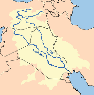
The Tigris is the eastern of the two great rivers that define Mesopotamia, the other being the Euphrates. The river flows south from the mountains of the Armenian Highlands through the Syrian and Arabian Deserts, before merging with the Euphrates and reaching to the Persian Gulf.
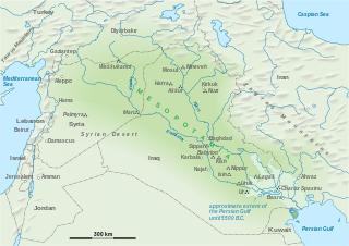
The geography of Mesopotamia, encompassing its ethnology and history, centered on the two great rivers, the Tigris and Euphrates. While the southern is flat and marshy, the near approach of the two rivers to one another, at a spot where the undulating plateau of the north sinks suddenly into the Babylonian alluvium, tends to separate them still more completely. In the earliest recorded times, the northern portion was included in Mesopotamia; it was marked off as Assyria after the rise of the Assyrian monarchy. Apart from Assur, the original capital of Assyria, the chief cities of the country, Nineveh, Kalaḫ and Arbela, were all on the east bank of the Tigris. The reason was its abundant supply of water, whereas the great plain on the western side had to depend on streams flowing into the Euphrates.
The Tigris–Euphrates river system is a large river system in Western Asia that flows into the Persian Gulf. Its primary rivers are the Tigris and Euphrates, along with smaller tributaries.

Hillah, also spelled Hilla, is a city in central Iraq. On the Hilla branch of the Euphrates River, it is 100 km (62 mi) south of Baghdad. The population was estimated to be about 455,700 in 2018. It is the capital of Babylon Province and is situated in a predominantly agricultural region which is extensively irrigated with water provided by the Hilla canal, producing a wide range of crops, fruit and textiles. Its name may be derived from the word "beauty" in Arabic. The river runs in the middle of the town, and it is surrounded by date palm trees and other forms of arid vegetation, reducing the harmful effects of dust and desert wind.
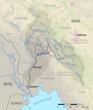
The Karun is the Iranian river with the highest water flow, and the country's only navigable river. It is 950 km (590 mi) long. The Karun rises in the Zard Kuh mountains of the Bakhtiari district in the Zagros Range, receiving many tributaries, such as the Dez and the Kuhrang. It passes through the city of Ahvaz, the capital of the Khuzestan Province of Iran, before emptying to its mouth into Arvand Rud.

The Tabqa Dam, or al-Thawra Dam as it is also named, most commonly known as Euphrates Dam, is an earthen dam on the Euphrates, located 40 kilometres (25 mi) upstream from the city of Raqqa in Raqqa Governorate, Syria. The city of Al-Thawrah is located immediately south of the dam. The dam is 60 metres (200 ft) high and 4.5 kilometres (2.8 mi) long and is the largest dam in Syria. Its construction led to the creation of Lake Assad, Syria's largest water reservoir. The dam was constructed between 1968 and 1973 with help from the Soviet Union. At the same time, an international effort was made to excavate and document as many archaeological remains as possible in the area of the future lake before they would be flooded by the rising water. When the flow of the Euphrates was reduced in 1974 to fill the lake behind the dam, a dispute broke out between Syria and Iraq that was settled by intervention from Saudi Arabia and the Soviet Union. The dam was originally built to generate hydroelectric power, as well as irrigate lands on both sides of the Euphrates. The dam has not reached its full potential in either of these objectives.

The Keban Dam is a hydroelectric dam on the Euphrates, located in the Elazığ Province of Turkey. The dam is the first and uppermost of several large-scale dams to be built on the Euphrates by Turkey. Although the Keban Dam was not originally constructed as a part of the Southeastern Anatolia Project (GAP), it is now a fully integrated component of the project, which aims to stimulate economic development in Southeastern Turkey. Construction of the dam commenced in 1966 and was completed in 1974. Keban Dam Lake, the reservoir created by Keban Dam, has a surface area of 675 square kilometres (261 sq mi) and is reputedly the fourth-largest lake in Turkey after Lake Van, Lake Tuz, and the reservoir created by the Atatürk Dam.

The Great Zab or Upper Zab is an approximately 400-kilometre (250 mi) long river flowing through Turkey and Iraq. It rises in Turkey near Lake Van and joins the Tigris in Iraq south of Mosul. During its course, the river collects water from many tributaries and the drainage basin of the Great Zab covers approximately 40,300 square kilometres (15,600 sq mi). The river and its tributaries are primarily fed by rainfall and snowmelt – as a result of which discharge fluctuates highly throughout the year. At least six dams have been planned on the Great Zab and its tributaries, but construction of only one, the Bekhme Dam, has commenced but was halted after the Gulf War.

The Haditha Dam or Qadisiya Dam is an earth-fill dam on the Euphrates, north of Haditha (Iraq), creating Lake Qadisiyah. The dam is just over 9 kilometres (5.6 mi) long and 57 metres (187 ft) high. The purpose of the dam is to generate hydroelectricity, regulate the flow of the Euphrates and provide water for irrigation. It is the second-largest hydroelectric contributor to the power system in Iraq behind the Mosul Dam.

Lake Assad is a reservoir on the Euphrates in Raqqa Governorate, Syria. It was created in 1974 when construction of the Tabqa Dam was completed. Lake Assad is Syria's largest lake, with a maximum capacity of 11.7 cubic kilometres (2.8 cu mi) and a maximum surface area of 525 square kilometres (203 sq mi). A vast network of canals uses water from Lake Assad to irrigate lands on both sides of the Euphrates. In addition, the lake provides drinking water for the city of Aleppo and supports a fishing industry. The shores of Lake Assad have developed into important ecological zones.

The Assiut Barrage is a dam on the Nile River in the city of Assiut in Upper Egypt. It was completed in 1903.
The Tishrin Dam is a dam on the Euphrates, located 90 kilometres (56 mi) east of Aleppo in Aleppo Governorate, Syria. The dam is 40 metres (130 ft) high and has 6 water turbines capable of producing 630 MW. Construction lasted between 1991 and 1999. Rescue excavations in the area that would be flooded by the dam's reservoir have provided important information on ancient settlement in the area from the Pre-Pottery Neolithic A (PPNA) period upward.
The Fallujah Barrage is a barrage on the Euphrates near Fallujah in Al Anbar Governorate, Iraq. Construction of the barrage was completed in 1985. Unlike many other dams in the Euphrates, the Fallujah Barrage does not include a hydroelectric power station and its main function is to raise the water level of the river for irrigation. The barrage consists of two separate parts. The main stretch of the barrage has ten gates measuring 16 by 8.5 metres, allowing a maximum discharge of 3,600 cubic metres (130,000 cu ft) per second. The second part on the left bank of the river has eight gates that are 6 metres (20 ft) wide. These gates divert water toward two separate irrigation channels. Their maximum discharge is 104 cubic metres (3,700 cu ft) per second.

The Kut Barrage is a barrage on the Tigris river, located in the modern town of Kut in Wasit Governorate, Iraq.

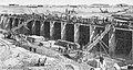
Al-Hindiya District is a district of the Karbala Governorate, Iraq. Its largest town is Al-Hindiya, to the east of Karbala. The Hindiya Barrage in the north of the district controls floods and diverts water from the Euphrates into irrigation canals on both sides of the river. The district has been the scene of clashes with Turkish and British colonial forces, and more recently with American troops in 2003. The population is about 230,000, mostly Shia, including significant numbers of refugees. Infrastructure is poor, but efforts are being made to improve it.

The Old Bridge, also known as the Old Tigris Bridge, is a ruined four-arch bridge spanning the Tigris River in the town of Hasankeyf in Batman Province in southeastern Turkey. It was built by the Artuqid Turkmens in the mid-12th century, between about 1147 and 1167, and at the time its central arch was one of the largest in the world, if not the largest. The bridge was repaired by Ayyubid Kurdish and Aq Qoyunlu Turkmen rulers during the 14th and 15th centuries and appears to have eventually collapsed in the early or mid-17th century. The bridge's ruined piers still stand, as does one arch. Since 2020 the ruins of the bridge, along with most of the town of Hasankeyf, have been submerged underwater by the filling of the Ilısu Dam reservoir.