The history of Madagascar is distinguished clearly by the early isolation of the landmass from the ancient supercontinent containing Africa and India, and by the island's late colonization by human settlers arriving in outrigger canoes from the Sunda islands between 200 BC and 500 AD. These two factors facilitated the evolution and survival of thousands of endemic plant and animal species, some of which have gone extinct or are currently threatened with extinction due to the pressures of a growing human population. Over the past two thousand years the island has received waves of settlers of diverse origins including Austronesian, Bantu, Arab, South Asian, Chinese and European populations. The majority of the population of Madagascar today is a mixture of Austronesian, Bantu, North Indian, Arab and Somali settlers. Centuries of intermarriages created the Malagasy people, who primarily speak Malagasy, an Austronesian language with Bantu, Malay, Arabic, French and English influences. Most of the genetic makeup of the average Malagasy, however, reflects an almost equal blend of Austronesian and Bantu influences, especially in coastal regions. Other populations often intermixed with the existent population to a more limited degree or have sought to preserve a separate community from the majority Malagasy.

The Madagascar People’s Armed Forces is the national military of Madagascar. The IISS detailed the armed forces in 2012 as including an Army of 12,500+, a Navy of 500, and a 500-strong Air Force. An alternate report describes the People's Armed Forces as consisting of the Intervention Force, Development Force, and Aeronaval Force, which is the navy and air force.

Antananarivo, also known by its colonial shorthand form Tana, is the capital and largest city of Madagascar. The larger urban area surrounding the city, known as Antananarivo-Renivohitra, is the capital of Analamanga region. The city is located 1,280 m (4,199 ft) above the sea level in the center of the island and has been the country's largest population center since at least the 18th century.

The highly diverse and distinctive music of Madagascar has been shaped by the musical traditions of Southeast Asia, Africa, Arabia, England, France and the United States as successive waves of settlers have made the island their home. Traditional instruments reflect these widespread origins: the mandoliny and kabosy owe their existence to the introduction of the guitar by early Arab or European seafarers, the ubiquitous djembe originated in mainland Africa and the valiha—the bamboo tube zither considered the national instrument of Madagascar—directly evolved from an earlier form of zither carried with the first Austronesian settlers on their outrigger canoes.
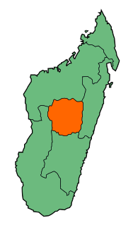
Antananarivo Province is a former province of Madagascar with an area of 58,283 square kilometres (22,503 sq mi). It had a population of 5,370,900 in 2004. Its capital was Antananarivo, which is also the capital of the country. Established in 1965, it was the most important province of Madagascar in terms of industrial production. It was one of the most literate provinces and was dominated by the Merina people. Along with the other five provinces, it was abolished in 2007 after a referendum in favour of creation of smaller regions to help in development was approved. It was badly affected by plagues in the 20th century. In 2002 a state of emergency was proclaimed by the then president Didier Ratsiraka. The events that followed led to the other five provinces announcing the creation of a new republic that would have excluded Antananarivo Province. Peace was restored only when Marc Ravalomanana was installed as the country's president.

Jean-Joseph Rabearivelo, born Joseph-Casimir Rabearivelo, is widely considered to be Africa's first modern poet and the greatest literary artist of Madagascar. Part of the first generation raised under French colonization, Rabearivelo grew up impoverished and failed to complete secondary education. His passion for French literature and traditional Malagasy poetry prompted him to read extensively and educate himself on a variety of subjects, including the French language and its poetic and prose traditions. He published his first poems as an adolescent in local literary reviews, soon obtaining employment at a publishing house where he worked as a proofreader and editor of its literary journals. He published numerous poetry anthologies in French and Malagasy, as well as literary critiques, an opera, and two novels.

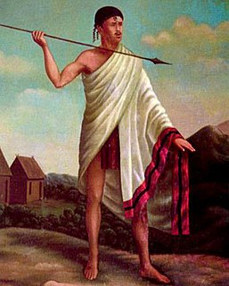
The Merina people are the largest ethnic group in Madagascar. They are the "highlander" Malagasy ethnic group of the African island and one of the country's eighteen official ethnic groups. Their origins are mixed, predominantly with Malayo-Indonesians arriving before the 5th century AD, then many centuries later by Arabs, Africans and other ethnic groups. They speak the Merina dialect of the official Malagasy language of Madagascar.

Ambohimanga is a hill and traditional fortified royal settlement (rova) in Madagascar, located approximately 24 kilometers (15 mi) northeast of the capital city of Antananarivo. The hill and the rova that stands on top are considered the most significant symbol of the cultural identity of the Merina people and the most important and best-preserved monument of the precolonial Merina Kingdom. The walled historic village includes residences and burial sites of several key monarchs. The site, one of the twelve sacred hills of Imerina, is associated with strong feelings of national identity and has maintained its spiritual and sacred character both in ritual practice and the popular imagination for at least four hundred years. It remains a place of worship to which pilgrims come from Madagascar and elsewhere.
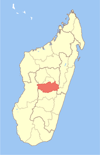
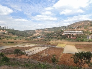
Vakinankaratra is a region in central Madagascar. The capital of the region is Antsirabe. Vakinankaratra covers an area of 16,599 kilometres, and had an estimated population of 1,803,307 in 2013.

Menabe is a region in western Madagascar, with its capital at Morondava. It covers an area of 46,121 square kilometres, and its population was estimated to be 592,113 in 2013. The population mostly belongs to the Sakalava ethnic group. The region is named after the 18th-century Sakalava Kingdom of Menabe. The name "Menabe", in turn, means "big red", after the color of laterite rock that dominates the landscape.

The Rova of Antananarivo is a royal palace complex (rova) in Madagascar that served as the home of the sovereigns of the Kingdom of Imerina in the 17th and 18th centuries, as well as of the rulers of the Kingdom of Madagascar in the 19th century. Its counterpart is the nearby fortified village of Ambohimanga, which served as the spiritual seat of the kingdom in contrast to the political significance of the Rova in the capital. Located in the central highland city of Antananarivo, the Rova occupies the highest point on Analamanga, formerly the highest of Antananarivo's many hills. Merina king Andrianjaka, who ruled Imerina from around 1610 until 1630, is believed to have captured Analamanga from a Vazimba king around 1610 or 1625 and erected the site's first fortified royal structure. Successive Merina kings continued to rule from the site until the fall of the monarchy in 1896, frequently restoring, modifying or adding royal structures within the compound to suit their needs.

Madagascar – United States relations are bilateral relations between Madagascar and the United States.

The Merina Kingdom, or the Kingdom of Imerina (c.1540–1897), was a pre-colonial state off the coast of Southeast Africa that, by the 19th century, dominated most of what is now Madagascar. It spread outward from Imerina, the Central Highlands region primarily inhabited by the Merina ethnic group with a spiritual capital at Ambohimanga and a political capital 24 kilometres (15 mi) west at Antananarivo, currently the seat of government for the modern state of Madagascar. The Merina kings and queens who ruled over greater Madagascar in the 19th century were the descendants of a long line of hereditary Merina royalty originating with Andriamanelo, who is traditionally credited with founding Imerina in 1540.
There is a small but recognizable community of French people in Madagascar, of whom the vast majority are born in Madagascar and are descended from former settlers and colonists from France who settled in Madagascar during the 19th and 20th centuries. They constitute a minority ethnic group of Madagascar.

The twelve sacred hills of Imerina are hills of historical significance to the Merina people of Madagascar. Located throughout Imerina, the central area of the highlands of Madagascar, the sites were often ancient capitals, the birthplaces of key public figures, or the tomb sites of esteemed political or spiritual leaders. The first set of sacred sites was designated by early 17th-century king Andrianjaka. The notion was re-sanctified under late 18th-century king Andrianampoinimerina, who replaced several of the earlier sites with new ones. More than 12 sites were thus designated as sacred over time, although the notion of twelve sacred hills was perpetuated because of the significance of the number 12 in Malagasy cosmology. Today, little concrete evidence of the former importance of many of these sites remains, but the significant archeological and cultural heritage of several of the sites has been preserved. The historic significance of the sites is best represented by the Rova of Antananarivo at Analamanga, the ancient fortified city at Alasora, the houses and tombs of the andriana at Antsahadinta and the ancient fortifications and palaces at Ambohimanga, protected as a UNESCO World Heritage Site since 2001.

Canada–Madagascar relations are foreign relations between Canada and Madagascar. Both countries are full members of the Francophonie, United Nations and the World Trade Organization.
The following is a timeline of the history of the city of Antananarivo, Madagascar.

The Institut national de l’information géographique et forestière , previously Institut géographique national or IGN is a French public state administrative establishment founded in 1940 to produce and maintain geographical information for France and its overseas departments and territories.

France, officially the French Republic, is a country whose territory consists of metropolitan France in Western Europe and several overseas regions and territories. The metropolitan area of France extends from the Mediterranean Sea to the English Channel and the North Sea, and from the Rhine to the Atlantic Ocean. It is bordered by Belgium, Luxembourg and Germany to the northeast, Switzerland and Italy to the east, and Andorra and Spain to the south. The overseas territories include French Guiana in South America and several islands in the Atlantic, Pacific and Indian oceans. The country's 18 integral regions span a combined area of 643,801 square kilometres (248,573 sq mi) and a total population of 67.3 million. France, a sovereign state, is a unitary semi-presidential republic with its capital in Paris, the country's largest city and main cultural and commercial centre. Other major urban areas include Lyon, Marseille, Toulouse, Bordeaux, Lille and Nice.