Nandihizana

Last updated
Nandihizana
Carion
Nandihizana.jpg
Nandihizana
Nickname: 
Carion gare TCE
Madagascar location map.svg
Red pog.svg
Nandihizana
Location in Madagascar
Coordinates: 18°54′S47°43′E / 18.900°S 47.717°E / -18.900; 47.717
CountryFlag of Madagascar.svg  Madagascar
Region Analamanga
District Manjakandriana
Area
  Total30.9 km2 (11.9 sq mi)
Elevation
[1]
1,429 m (4,688 ft)
Population
 (2001) [2]
  Total5,000
Time zone UTC3 (EAT)
Postal code
116

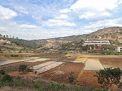
Nandihizana is a municipality in Madagascar. Its previous name was Carion. It belongs to the district of Manjakandriana, which is a part of Analamanga Region. The population of this municipality was estimated to be approximately 5,000 in 2001 commune census. [2]

The mount Angavobe Angavobe depuis l'est.jpg
The mount Angavobe

Nandihizana (or Carion) is a famous train station of the line TCE (Tananarive Côte Est). The city became famous with its train station in the seventies due to the trees and wood business organised by Farariana natives businessmen. Primary and junior level secondary education are available in town. The majority 96% of the population of the commune are farmers. The most important crop is rice, while other important products are fruits, beans and cassava. Industry and services provide employment for 1% and 3% of the population, respectively. [2]


Nature

The two inselbergs of Angavokely (1752 m) and Angavobe (1755 m) are situated in Nandihizana. [3]

Related Research Articles

Sabotsy Anjiro is a rural municipality that is composed by two towns in Madagascar. It belongs to the district of Moramanga, which is a part of Alaotra-Mangoro Region. The population of the commune was estimated to be 17,418 in 2018 and lies approximately 80 km west of Antananarivo, along the National Road 2 to Toamasina.

Morarano is a town and commune in Madagascar. It belongs to the district of Arivonimamo, which is a part of Itasy Region. The population of the commune was estimated to be approximately 13,000 in 2001 commune census.

Nasandratrony is a rural municipality in Madagascar.

Vinanitelo is a town and commune in Madagascar. It belongs to the district of Fianarantsoa II, which is a part of Haute Matsiatra Region. The population of the commune was estimated to be approximately 10,000 in 2001 commune census.

Ambahive is a town and commune in Madagascar. It belongs to the district of Manakara, which is a part of Vatovavy-Fitovinany Region. The population of the commune was estimated to be approximately 15,000 in 2001 commune census.

Bekatra is a town and commune in Madagascar. It belongs to the district of Manakara, which is a part of Vatovavy-Fitovinany Region. The population of the commune was estimated to be approximately 20,000 in 2001 commune census.

Mahabako is a town and commune in Madagascar. It belongs to the district of Manakara, which is a part of Vatovavy-Fitovinany Region. The population of the commune was estimated to be approximately 10,000 in 2001 commune census.

Androrangavola is a rural municipality in Madagascar. It belongs to the district of Ifanadiana, which is a part of Vatovavy. The population of this municipality was 14,709 inhabitants in 2018.

Savana is a town and commune in Madagascar. It belongs to the district of Vohipeno, which is a part of Vatovavy-Fitovinany Region. The population of the commune was estimated to be approximately 4,000 in the 2001 commune census.

Beretra Bevoay is a town and commune in Madagascar. It belongs to the district of Farafangana, which is a part of Atsimo-Atsinanana Region. The population of the commune was estimated to be approximately 10,000 in 2001 commune census.

Isahara is a town and commune in Madagascar. It belongs to the district of Vangaindrano, which is a part of Atsimo-Atsinanana Region. The population of the commune was estimated to be approximately 10,000 according to the 2001 commune census.

Vohimalaza is a town and commune in Madagascar. It belongs to the district of Vangaindrano, which is a part of Atsimo-Atsinanana Region. The population of the commune was estimated to be approximately 7,000 in 2001 commune census.

Anjoma Nandihizana is a town and commune in Madagascar. It belongs to the district of Manandriana, which is a part of Amoron'i Mania Region. The population of the commune was estimated to be approximately 13,000 in 2001 commune census.

Ambohimitombo is a town and commune in Madagascar. It belongs to the district of Ambositra, which is a part of Amoron'i Mania Region. The population of the commune was estimated to be approximately 14,000 in 2001 commune census.

<span class="mw-page-title-main">Ambanitsena</span> Place in Analamanga, Madagascar

Ambanitsena is a rural municipality in Madagascar. It belongs to the district of Manjakandriana, which is a part of Analamanga Region. The population of the commune was estimated to be approximately 6,000 in 2001 commune census.

Ambatolaona is a rural municipality in Madagascar. It belongs to the district of Manjakandriana, which is a part of Analamanga Region. The population of the commune was estimated to be approximately 5,000 in 2001 commune census.

Anjepy is a town and commune in Madagascar. It belongs to the district of Manjakandriana, which is a part of Analamanga Region. The population of the commune was estimated to be approximately 6,000 in 2001 commune census.

Anjoma Betoho is a town and commune in Madagascar. It belongs to the district of Manjakandriana, which is a part of Analamanga Region. The population of the commune was estimated to be approximately 3,000 in 2001 commune census.

<span class="mw-page-title-main">Sambaina</span> Place in Analamanga, Madagascar

Sambaina is the name of several towns and communes in Madagascar. Sambaina (Manjakandriana) belongs to the district of Manjakandriana, which is a part of Analamanga Region. The population of the commune was estimated to be approximately 7,831 in 2018.

Antsahalalina is a rural municipality in Madagascar. It belongs to the district of Manjakandriana, which is a part of Analamanga Region. The population of the commune was estimated to be approximately 4,000 in 2001 commune census.

References

  1. Estimated based on DEM data from Shuttle Radar Topography Mission
  2. 1 2 3 "ILO census data". Cornell University. 2002. Retrieved 2008-06-03.
  3. Inselbergs Angavokely & Angavobe

Coordinates: 18°54′S47°43′E / 18.900°S 47.717°E / -18.900; 47.717