
Antananarivo, also known by its colonial shorthand form Tana, is the capital and largest city of Madagascar. The administrative area of the city, known as Antananarivo-Renivohitra, is the capital of Analamanga region. The city sits at 1,280 m (4,199 ft) above sea level in the center of the island, the highest national capital by elevation among the island countries. It has been the country's largest population center since at least the 18th century. The presidency, National Assembly, Senate and Supreme Court are located there, as are 21 diplomatic missions and the headquarters of many national and international businesses and NGOs. It has more universities, nightclubs, art venues, and medical services than any city on the island. Several national and local sports teams, including the championship-winning national rugby team, the Makis are based here.
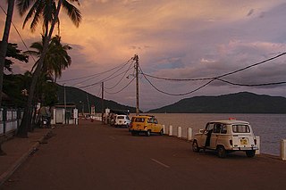
Andoany, formerly and more commonly known as Hell-Ville, is a city in Diana Region, Madagascar with a population estimated at 39,500 in 2013. It lies on the island of Nosy Be, of which it is the capital. It is located at 13°24′0″S48°16′0″E.

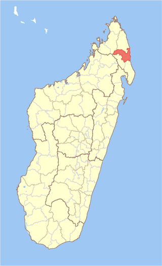
Sofia is a region in northern Madagascar. It is named for the Sofia River. The region covers 50,100 km² and had a population of 1,500,227 in 2018. The administrative capital is Antsohihy.

Vakinankaratra is a region in central Madagascar. The capital of the region is Antsirabe. Vakinankaratra covers an area of 16,599 kilometres, and had a population of 2,074,358 in 2018.

Analamanga is a region in central Madagascar, containing the capital Antananarivo and its surrounding metropolitan area. The region has an area of 17,488 square kilometres, and had a population of 3,618,128 in 2018.

Bongolava is a region in central-western Madagascar. The capital of the region is Tsiroanomandidy. It had a population of 674,474 in 2018.
Ambovombe-Androy[ambuˈvumbe ˈaɳɖʐuj], or just Ambovombe, is a city in the far south of Madagascar, and the capital of the Androy region. Ambovombe has now acquired city status with an officially estimated population in 2018 of 114,230.

Ambatolampy is a city in the Vakinankaratra Region, situated in the Central Highlands of Madagascar. It had a population of about 28,500 in 2013.

Alaotra-Mangoro is a region in eastern Madagascar. It borders Sofia Region in north, Analanjirofo in northeast, Atsinanana in east, Vakinankaratra in southwest, Analamanga in west and Betsiboka in northwest. The capital of the region is Ambatondrazaka, and the population was 1,255,514 in 2018. The area of the region is 31,948 km2 (12,335 sq mi).
Andapa District is a district in northern Madagascar. It is a part of Sava Region and borders the districts of Ambilobe and Sambava to the north, Antalaha to the east, Maroantsetra to the south, and Befandriana Nord and Bealanana to the west. The area is 4,051.48 km2 (1,564 sq mi) and the population was estimated to be 189,882 in 2013.
Sambava District is a district in northern Madagascar. It is a part of Sava Region and borders the districts of Antalaha to the south, Andapa to the south-west, Ambilobe to the north-west and Iharana to the north. The area is 4,681.76 km2 (1,808 sq mi) and the population was estimated to be 304,366 in 2013.

Districts are second-level administrative divisions of Madagascar below the regions. There are 114 districts in Madagascar. Districts are in their turn divided into communes; while some of the districts in urban areas and offshore islands each consist of only one commune, most of the districts are divided typically into 5–20 communes.
Ivato or Ivato Centre is a rural commune (town) in Madagascar. It belongs to the Ambositra District, which is a part of the Amoron'i Mania region.

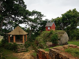
The twelve sacred hills of Imerina are hills of historical significance to the Merina people of Madagascar. Located throughout Imerina, the central area of the highlands of Madagascar, the sites were often ancient capitals, the birthplaces of key public figures, or the tomb sites of esteemed political or spiritual leaders. The first set of sacred sites was designated by early 17th-century king Andrianjaka. The notion was re-sanctified under late 18th-century king Andrianampoinimerina, who replaced several of the earlier sites with new ones. More than 12 sites were thus designated as sacred over time, although the notion of twelve sacred hills was perpetuated because of the significance of the number 12 in Malagasy cosmology. Today, little concrete evidence of the former importance of many of these sites remains, but the significant archeological and cultural heritage of several of the sites has been preserved. The historic significance of the sites is best represented by the Rova of Antananarivo at Analamanga, the ancient fortified city at Alasora, the houses and tombs of the andriana at Antsahadinta and the ancient fortifications and palaces at Ambohimanga, protected as a UNESCO World Heritage Site since 2001.

Ambatofinandrahana District is a district in central Madagascar. It is part of Amoron'i Mania Region. It coverts an area of 10,321.48 km2, and in 2013 its population was estimated at 155,470. Its capital is Ambatofinandrahana.
Manandriana District is a district in central Madagascar. It is part of Amoron'i Mania Region. It covers an area of 981.98 sq.km, and had a population of 95,594 in 2013. Its capital is Ambovombe Afovoany.
A rova is a fortified royal complex built in the central highlands of Madagascar by Merina of the Andriana (noble) class. The first rova was established at Alasora by king Andriamanelo around 1540 to protect his residence throughout a war with the neighboring Vazimba. Rovas are organized according to traditional symbolic notions of space and enclose the royal residences, the tomb of the founder, and a town square marked with a stone. They are protected with walls, trenches and stone gateways and are planted with fig trees symbolic of royalty.
Antananarivo-Avaradrano is a district of Analamanga in Madagascar.
Andriamangarira was a king from the Merina Kingdom in Madagascar. He founded the royal city of Antsahadinta in around 1725. He was the grandson of King Andriamasinavalona, son of Rasohanamanjaka of Ambohimahamanina, one of his daughters, with a certain Andriandambozozoro, Lord of Ivatobe avaratra and Malaza in Ambodirano Imerinatsimo. The tomb of Andriamangarira, qualified as a « Pirogue grave », and his « Tranomasina » according to traditions, are still visible in Antsahadinta.


