
Cape Town is the second-most populous city in South Africa, after Johannesburg, and also the legislative capital of South Africa.

Lleida is a city in the west of Catalonia, Spain. It is the capital city of the province of Lleida.

A municipality is usually a single administrative division having corporate status and powers of self-government or jurisdiction as granted by national and regional laws to which it is subordinate.

Pas-de-Calais is a department in northern France named after the French designation of the Strait of Dover, which it borders.
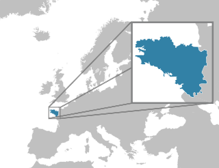
Brittany is a peninsula, historic country and cultural region in the west of modern France, covering the western part of what was known as Armorica during the period of Roman occupation. It became an independent kingdom and then a duchy before being united with the Kingdom of France in 1532 as a province governed as a separate nation under the crown.

A ghost town or alternatively deserted city or abandoned city is an abandoned village, town, or city, usually one that contains substantial visible remaining buildings and infrastructure such as roads. A town often becomes a ghost town because the economic activity that supported it has failed, or due to natural or human-caused disasters such as floods, prolonged droughts, extreme heat or extreme cold, government actions, uncontrolled lawlessness, war, pollution, or nuclear disasters. The term can sometimes refer to cities, towns, and neighbourhoods that are still populated, but significantly less so than in past years; for example, those affected by high levels of unemployment and dereliction.

Nice is the seventh most populous urban area in France and the capital of the Alpes-Maritimes department. The metropolitan area of Nice extends beyond the administrative city limits, with a population of nearly 1 million on an area of 744 km2 (287 sq mi). Located in the French Riviera, on the south east coast of France on the Mediterranean Sea, at the foot of the Alps, Nice is the second-largest French city on the Mediterranean coast and the second-largest city in the Provence-Alpes-Côte d'Azur region after Marseille. Nice is approximately 13 kilometres (8.1 mi) from the principality of Monaco and 30 kilometres (19 mi) from the French-Italian border. Nice's airport serves as a gateway to the region.

Brest is a port city in the Finistère département in Brittany. Located in a sheltered bay not far from the western tip of the peninsula, and the western extremity of metropolitan France, Brest is an important harbour and the second French military port after Toulon. The city is located on the western edge of continental Europe. With 142,722 inhabitants in a 2007 census, Brest forms Western Brittany's largest metropolitan area, ranking third behind only Nantes and Rennes in the whole of historic Brittany, and the 19th most populous city in France; moreover, Brest provides services to the one million inhabitants of Western Brittany. Although Brest is by far the largest city in Finistère, the préfecture of the department is the much smaller Quimper.

Calais is a city and major ferry port in northern France in the department of Pas-de-Calais, of which it is a sub-prefecture. Although Calais is by far the largest city in Pas-de-Calais, the department's prefecture is its third-largest town of Arras. The population of the city proper is 73,911, and that of the urban area is 128,931 (2017). Calais overlooks the Strait of Dover, the narrowest point in the English Channel, which is only 34 km (21 mi) wide here, and is the closest French town to England. The White Cliffs of Dover can easily be seen on a clear day from Calais. Calais is a major port for ferries between France and England, and since 1994, the Channel Tunnel has linked nearby Coquelles to Folkestone by rail.

Ashby-de-la-Zouch or Ashby de la Zouch is a market town and civil parish in North West Leicestershire, England, near the Derbyshire and Staffordshire borders. Its 2001 census population of 11,410 rose to 12,370 in 2011. Ashby de la Zouch Castle was important in the 15th–17th centuries. In the 19th century the town's main industries were ribbon manufacture, coal mining, and brickmaking. From 1849 it was served by the Leicester–Burton upon Trent line of the Midland Railway.

Mulhouse is a subprefecture of the Haut-Rhin department in the Grand Est region of Eastern France, close to the Swiss and German borders. With a population of 108,942 in 2018 in the commune and 246,692 inhabitants in 2017 in the urban unit, it is the largest city in Haut-Rhin and second largest in Alsace after Strasbourg. Mulhouse is the principal commune of the 39 communes which make up the communauté d'agglomération of Mulhouse Alsace Agglomération.
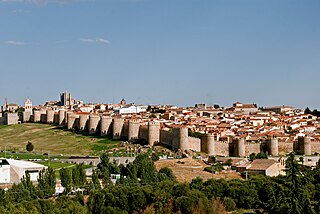
Ávila is a city of Spain located in the autonomous community of Castile and León. It is the capital and most populated municipality of the Province of Ávila.

A sister city, or twin town, relationship is a form of legal or social agreement between two geographically and politically distinct localities for the purpose of promoting cultural and commercial ties.

Villarreal, officially called Vila-real, is a city in the province of Castellón which is part of the Valencian Community in the east of Spain.

San Miguel de Allende is the principal city in the municipality of San Miguel de Allende, located in the far eastern part of Guanajuato, Mexico. A part of the Bajío region, the city lies 274 km (170 mi) from Mexico City, 86 km (53 mi) from Querétaro, and 97 km (60 mi) from the state capital of Guanajuato. The city's name derives from two persons: 16th-century friar Juan de San Miguel, and a martyr of Mexican Independence, Ignacio Allende, who was born in a house facing the city's central plaza. San Miguel de Allende was also a critical epicenter during the historic Chichimeca War (1540–1590) where the Chichimeca Confederation defeated the Spanish Empire in the initial colonization war. Today, an old section of the town is part of a proclaimed World Heritage Site, attracting thousands of tourists and new residents from abroad every year.

An administrative centre is a seat of regional administration or local government, or a county town, or the place where the central administration of a commune is located.

San Sebastián or Donostia is a coastal city and municipality located in the Basque Autonomous Community, Spain. It lies on the coast of the Bay of Biscay, 20 km from the French border. The capital city of the province of Gipuzkoa, the municipality's population is 186,095 as of 2015, with its metropolitan area reaching 436,500 in 2010. Locals call themselves donostiarra (singular), both in Spanish and Basque.

"Old Town Road" is a song by American rapper Lil Nas X, first released independently in December 2018. After gaining popularity, the single was re-released by Columbia Records in March 2019. Lil Nas X also recorded a remix with American country singer Billy Ray Cyrus, which was released on April 5, 2019. Both were included on Lil Nas X's first EP, 7 (2019).


