
Route 35 is a state highway in the U.S. state of New Jersey, primarily traveling through the easternmost parts of Middlesex, Monmouth, and Ocean counties. It runs 58.1 mi (93.5 km) from the entrance to Island Beach State Park in Berkeley Township, Ocean County, to an intersection with Lincoln Highway/St. Georges Avenue (Route 27) in Rahway, Union County. Between Seaside Park and Mantoloking, Route 35 follows the right-of-way of the former Pennsylvania Railroad along the Jersey Shore. The route heads through Point Pleasant Beach and crosses the Manasquan River on the Brielle Bridge, meeting the intersection of Route 34 and Route 70 at the former Brielle Circle in Wall Township. From there, Route 35 heads north and interchanges with Route 138, an extension of I-195, continuing north through Monmouth County before crossing the Victory Bridge over the Raritan River into Perth Amboy, where the route continues north to Rahway.

Route 71 is a state highway in New Jersey that runs 16.7 miles (26.9 km) near the shore in Monmouth County. It begins at Route 35 in Brielle just north of the Manasquan River and the Ocean County line and heads north to Route 35 in Eatontown with a four block concurrency with Route 35 in Belmar. Monmouth University is located off Route 71 in West Long Branch.

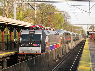
NJ Transit Rail Operations is the rail division of NJ Transit. It operates commuter rail service in New Jersey, with most service centered on transportation to and from New York City, Hoboken, and Newark. NJ Transit also operates rail service in Orange and Rockland counties in New York under contract to Metro-North Railroad. The commuter rail lines saw 57,179,000 riders in 2023, making it the third-busiest commuter railroad in North America and the longest commuter rail system in North America by route length.
The Gladstone Branch is a commuter rail line operated by NJ Transit in the U.S. state of New Jersey, one of two branches of the Morris & Essex Lines. Gladstone Line trains operate between Gladstone station and either Hoboken Terminal or New York Penn Station.
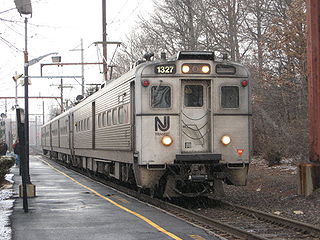
The North Jersey Coast Line is a commuter rail line running from Rahway to Bay Head, New Jersey, traversing through the Jersey Shore region. Operated by New Jersey Transit, the line is electrified as far south as Long Branch. On rail system maps it is colored light blue, and its symbol is a sailboat. The line runs along the former New York & Long Branch Railroad, which was co-owned by the Central Railroad of New Jersey and the Pennsylvania Railroad.
The New York and Long Branch Railroad was a railroad in central New Jersey, running from Bay Head Junction in Bay Head to Perth Amboy, where it connected to the Central Railroad of New Jersey's Perth Amboy and Elizabethport Railroad. The railroad was jointly owned and operated by the Pennsylvania Railroad and the Central Railroad of New Jersey and became property of Conrail in 1976. It is now part of New Jersey Transit's North Jersey Coast Line.
New Jersey's 4th congressional district is a congressional district that stretches along the New Jersey Shore. It has been represented by Republican Chris Smith since 1981, the second-longest currently serving member of the US House of Representatives and the longest serving member of Congress from New Jersey in history.

Allaire State Park is a park located in Howell and in Wall Township in Monmouth County, New Jersey, United States, near the borough of Farmingdale, operated and maintained by the New Jersey Division of Parks and Forestry and is part of the New Jersey Coastal Heritage Trail Route. The park is known for its restored 19th century ironworks, Allaire Village, on the park premises. It is named after James P. Allaire, founder of the Howell Works at the same site. The park also hosts the Pine Creek Railroad, a tourist railroad.

County Route 524 is a county highway in the U.S. state of New Jersey. The highway extends 39.90 miles (64.21 km) from the White Horse Circle in Hamilton Township to Route 71 in Spring Lake Heights.
The Manasquan Public Schools is a comprehensive community public school district that serves students from kindergarten through twelfth grade from Manasquan, in Monmouth County, in the U.S. state of New Jersey.
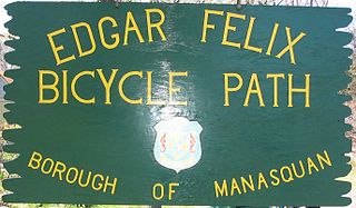
The Edgar Felix Bikeway is a 5.4 miles (8.7 km) rail trail in New Jersey between Manasquan and Allaire State Park. The trail was constructed on a former roadbed of the Farmingdale and Squan Village Railroad and the Freehold and Jamesburg Agricultural Railroad.
The Freehold and Jamesburg Agricultural Railroad was a short-line railroad in New Jersey. The railroad traversed through the communities of Freehold Borough, Freehold Township, Manalapan Township, Englishtown Borough, Monroe Township, and Jamesburg Borough, en route to Monmouth Junction in South Brunswick Township.

Spring Lake is a commuter railroad station in the borough of Spring Lake, Monmouth County, New Jersey, United States. Located near the border with Spring Lake Heights, trains are served by New Jersey Transit's North Jersey Coast Line, which serve stations from New York Penn Station, Hoboken Terminal and Long Branch to Bay Head. The next station northward is Belmar, while the next station south is Manasquan. Spring Lake station lacks accessibility for handicapped persons per the Americans With Disabilities Act of 1990.

The New Jersey Southern Railroad was a railroad that started in 1854. It would continue under this name until the 1870s as a separate company and the lines that it had constructed or run continued to be run in the New Jersey Southern name until the early 2000s.
The New Jersey Museum of Transportation is a museum dedicated to the collection, preservation, and operation of historic railroad equipment. The organization runs excursion trains on a 3 ft narrow gauge tourist railroad named the Pine Creek Railroad. The museum is independently operated as a 501(c)(3) nonprofit organization along with the Allaire Village and is located in Allaire State Park in New Jersey. The museum runs Easter Bunny Express trains in April, Haunted Halloween trains in October, and Santa Special trains on the weekends in December.

The Freehold Secondary is an active rail line in New Jersey, the tracks of which are owned by Conrail Shared Assets Operations (CSAO) and operated by the Delaware and Raritan River Railroad (DRR), a subsidiary of Chesapeake and Delaware, LLC. The active portion operates between Jamesburg and Lakewood, New Jersey. The section between Freehold and the junction with the Southern Secondary in Farmingdale had been dormant since 1999; DRR began track rehabilitation on this section on January 16, 2023. On October 13, 2023, the 5–mile Farmingdale–Freehold segment was officially reactivated. In total, 25,000+ feet of rail, 12,500 ties and seven level crossings were replaced in a project that concluded nine months ahead of schedule and under budget. This project makes the operation more efficient, as one train can now serve on-line customers between Browns Yard in Old Bridge, where the train originates, to the line's largest and southernmost customer in Lakewood. DRR intends to grow business with future plans to reactivate dormant track south of Lakewood.
The Monmouth Ocean Middlesex Line (MOM) is a passenger rail project in the US state of New Jersey, proposed by NJ Transit Rail Operations (NJT) to serve the Central New Jersey counties of Monmouth, Ocean, and Middlesex. The line would originate/terminate around Lakehurst at its southern end. It would junction with either the Northeast Corridor Line or North Jersey Coast Line to provide service north to Newark Penn Station, with potential connecting or continuing service to Hoboken Terminal or New York Penn Station.
Brielle Draw is a railroad bascule bridge over Manasquan River in Brielle, Monmouth County and Point Pleasant Beach, Ocean County, New Jersey, United States west of the Manasquan Inlet to the Atlantic Ocean. It carries a single track of the New Jersey Transit Rail Operations (NJT) North Jersey Coast Line between Manasquan and Point Pleasant Beach stations. It had once been part of Central Railroad of New Jersey (CNJ), New York & Long Branch Railroad (NYLB) and Pennsylvania Railroad (PRR) operations. The line is also served by the River Draw over the Raritan River, the Morgan Draw over Cheesequake Creek, the Oceanport Draw over Oceanport Creek and the Shark River Draw.
The Delaware and Raritan River Railroad is a short-line railroad that operates two lines in the central part of the U.S. state of New Jersey. The Southern Secondary runs from an interchange with Conrail Shared Assets Operations (CSAO) in Red Bank south to Lakewood. The Freehold Secondary runs from an interchange with CSAO in Jamesburg southeast to Farmingdale, New Jersey.. The Delaware and Raritan River Railroad is a subsidiary of Chesapeake and Delaware, LLC.

