
Trinidad and Tobago is an archipelagic republic in the southern Caribbean between the Caribbean Sea and the North Atlantic Ocean, northeast of Venezuela. They are southeasterly islands of the Lesser Antilles, Monos, Huevos, Gaspar Grande, Little Tobago, and St. Giles Island. Trinidad is 11 km (6.8 mi) off the northeast coast of Venezuela and 130 km (81 mi) south of the Grenadines. The island measures 4,768 km2 (1,841 sq mi) in area with an average length of 80 km (50 mi) and an average width of 59 km (37 mi). The island appears rectangular in shape with three projecting peninsular corners. Tobago is 30 km (19 mi) northeast of Trinidad and measures about 298 km2 (115 sq mi) in area, or 5.8% of the country's area, 41 km (25.5 mi) in length and 12 km (7.5 mi) at its greatest width. The island is cigar-shaped in appearance, with a northeast–southwest alignment.

Trinidad is the larger and more populous of the two major islands of Trinidad and Tobago. The island lies 11 km (6.8 mi) off the northeastern coast of Venezuela and sits on the continental shelf of South America. It is often referred to as the southernmost island in the West Indies. With an area of 4,768 km2 (1,841 sq mi), it is also the fifth largest in the West Indies.

Mazatlán is a city in the Mexican state of Sinaloa. The city serves as the municipal seat for the surrounding municipio, known as the Mazatlán Municipality. It is located on the Pacific coast across from the southernmost tip of the Baja California Peninsula.

The Bishop Rock is a skerry off the British coast in the northern Atlantic Ocean known for its lighthouse. It is in the westernmost part of the Isles of Scilly, an archipelago 45 kilometres off the southwestern tip of the Cornish peninsula of Great Britain. The Guinness Book of Records lists it as the world's smallest island with a building on it.

The Martinique national football team represents the French overseas department and region of Martinique in international football. The team is controlled by the Ligue de Football de la Martinique, a local branch of French Football Federation. The association is not a member of the world governing body FIFA. On 7 August 2010, the team adopted the nickname Les Matinino, which pays tribute to the history of the island.

Trinidad and Tobago, officially the Republic of Trinidad and Tobago, is the southernmost island country in the Caribbean. Consisting of the main islands Trinidad and Tobago and numerous much smaller islands, it is situated 11 kilometres off the coast of northeastern Venezuela and 130 kilometres south of Grenada. It shares maritime boundaries with Barbados to the east, Grenada to the northwest and Venezuela to the south and west. Trinidad and Tobago is generally considered to be part of the West Indies. The island country's capital is Port of Spain, while its largest and most populous municipality is Chaguanas.
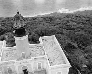
Caja de Muertos Light, is an 1887 lighthouse in Ponce, Puerto Rico, that is unique amongst all other lighthouses in Puerto Rico for its unusual Cross of Lorraine, double-arm, T-type shape structure. The historic lighthouse is located in Caja de Muertos, an uninhabited island off the coast of Ponce, Puerto Rico. The light stands at the highest point of the island.

Cape Bojeador Lighthouse, also known as Burgos Lighthouse, is a cultural heritage structure in Burgos, Ilocos Norte, that was established during the Spanish colonial period in the Philippines. The lighthouse was first lit on March 30, 1892, and is set high on Vigia de Nagpartian Hill overlooking the scenic Cape Bojeador where early galleons used to sail by. After over 100 years, it still functions and serves ships that enter the Philippine archipelago from the north and guide them safely away from the rocky coast of the town.

Cape Engaño Lighthouse, also known as Faro de Cabo Engaño, is a historic lighthouse located at Cape Engaño on Palaui Island in the town of Santa Ana, the province of Cagayan, Philippines. Located at the northernmost part of Luzon Island and situated atop the summit of a hill, 92 meters above sea level, the lighthouse provides a 360-degree view of Babuyan Island and the Dos Hermanas Island on the North, Pacific Ocean on the West and Engaño cove on the East.

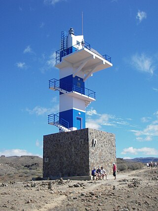
The Fuencaliente Lighthouse is an active lighthouse at the southern end of the island of La Palma in the Canary Islands. The original lighthouse was built in 1903 and while it still exists it was replaced by the current lighthouse in 1985. It is one of a number of lighthouses in the Canary Islands.

The Maspalomas Lighthouse is an active 19th century lighthouse at the southern end of the Spanish island of Gran Canaria, in the Canary archipelago. It lies at one end of the Maspalomas beach, 4 kilometres (2.5 mi) south of the resort town centre, next to the area known as the Maspalomas Dunes.

The Punta Martiño Lighthouse is an active lighthouse on the Canary island of Lobos, near Fuerteventura in the municipality of La Oliva.
The Punta del Castillete Lighthouse is an active lighthouse on the Canary island of Gran Canaria. It is located on cliffs above the resort and fishing harbour of Puerto de Mogán, in the municipality of Mogán. Punta Castillete is on the south-western side of the island facing the Atlantic Ocean, and lies between Maspalomas Lighthouse to the south and the lighthouse of Punta Sardina to the north.

The Punta de Arinaga Lighthouse is an active lighthouse on the Spanish island of Gran Canaria in the Canary islands. The current lighthouse tower is the third to be constructed on the rocky headland of Punta Arinaga, near the town of the same name in the municipality of Agüimes. Arinaga is on the south-east side of the island and marks the coastline between the Maspalomas lighthouse to the south and the Punta de Melenara lighthouse of Telde to the north.

The Punta de Melenara Lighthouse also known as the Faro de Taliarte is an active 20th century lighthouse on the Spanish island of Gran Canaria in the Canary islands.

La Isleta Lighthouse is an active 19th century lighthouse on the Spanish island of Gran Canaria in the Canary islands. The lighthouse has been constructed on the rocky peninsula of La Isleta, which overlooks the Port of Las Palmas to the north of the city of Las Palmas, the capital of Gran Canaria. Situated at the north-eastern tip of the island, the La Isleta light marks the approaches to the port and lies midway between the Sardina lighthouse to the east and the Punta de Melenara lighthouse of Telde to the south.

The San Cristóbal Lighthouse is an active lighthouse on the Spanish island of La Gomera in the Canary islands. The current lighthouse is the second to have been constructed on the rocky headland of Punta de San Cristóbal, on the eastern side of the island, overlooking the approaches to San Sebastián de La Gomera, the main port and capital of La Gomera.

Punta Lava Lighthouse is an active 20th century Spanish lighthouse on the Canary island of La Palma. It is located in the municipality of Tazacorte, near the village of La Bombilla on the western side of the island. The larger settlement of Puerto Naos lies 2 kilometres to the south-west.

Crestón Island or 'Crestón Hill' is located in the southern part of the mexican city of Mazatlán. It is the highest point in the entire city.


