Related Research Articles

Amreli district is one of the 33 administrative districts of the state of Gujarat in western India. The district headquarters are located at Amreli. The district occupies an area of 6,760 km2 and has a population of 1,514,190 of which 22.45% were urban. Amreli is the land of Yogiji Maharaj(Dhari), Danbapu, Sage Muldas, Sage Bhojalrambapa, Sage Muktanand Swami, Magician K.Lal, Zaverchand Megahani's place (Bagasara), Dr. Jivaraj Mehata etc. Amreli covers Dhari Gir National forest sanctuary area. Now it is developing as a Hub of Education.
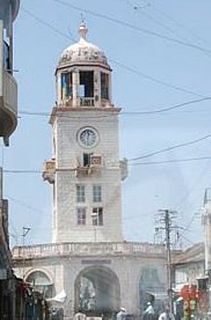
Amreli is a city and a municipality in Amreli district in Indian state of Gujarat.
Chalala is a town and a municipality in Amreli district in the state of Gujarat, India.
Damnagar is a census town in Amreli district in the state of Gujarat, India.
Gariadhar is a city and a municipality in Bhavnagar district in the state of Gujarat, India.

Dhari is a town in Amreli District in Indian state of Gujarat, India. It is an administrative headquarter of the Dhari tehsil(almost 87 villages and ness).Dhari is the most populous town in Amreli District as per census 2011 with 30352 population. Dhari is located on the bank of Shetrunji River, 42 km(26.2 mi) from district headquarter Amreli & 318 km(199.8 mi) from state capital Gandhinagar. Dhari is famous for kesar mango and Asiatic lion. Dhari is capital of East Gir Forest.
Amreli Lok Sabha constituency is one of the 26 Lok Sabha (parliamentary) constituencies in Gujarat state in western India.
Devrajiya is a village in the Amreli district of India. Devrajiya was under the control of the Amreli state during the Navabshahi.Local business mainly consists of agriculture and diamonds.
Fatehpur, Fatepur, or Phattepur may refer to any of a number of places:

Bhoja Bhagat (1785–1850), also known as Bhojal or Bhojalram was a Hindu saint poet from Gujarat, India.
Valamram (1824–1886) was a prominent Hindu saint & social reformer of the 19th century from Gujarat, who was disciple of Bhoja Bhagat. He lived in Gariadhar. He was Guru-Bhai of Jalaram of Virpur.

Botad District is a district of the state of Gujarat, India. It was created on 15 August 2013 from the southwestern part of Ahmedabad District and the northwestern part of Bhavnagar District. Botad consist of four talukas: Botad, Gadhada, Barvala, Ranpur. Botad city is the administrative headquarters of the district.
Dhari is one of the 182 Legislative Assembly constituencies of Gujarat state in India. It is part of Amreli district, and is a segment of Amreli.
Amreli is one of the 182 Legislative Assembly constituencies of Gujarat state in India.
Lathi is one of the 182 Legislative Assembly constituencies of Gujarat state in India. It is part of Amreli district.
Savarkundla is one of the 182 Legislative Assembly constituencies of Gujarat state in India. It is part of Amreli district and it came into existence after 2008 delimitation.

Balel Pipariya is a City in the Amreli district, Gujarat, India.
Dahida is a village in Dhari Taluka of Amreli district, Gujarat, India. It is a former non-salute princely state.
Lakhapadar is a village and former non-salute princely state on the Saurashtra peninsula in Gujarat, western India.
Chital is a village in Amreli Taluka of Amreli district, Gujarat, India.
References
- ↑ District census handbook. India. Superintendent of Census Operations, Gujarat. 1964. p. 33.
- ↑ (India), Gujarat (1972). Gujarat State Gazetteers: Amreli. p. 641.
Coordinates: 21°34′05″N71°12′40″E / 21.568°N 71.211°E
| | This article about a location in Amreli district, Gujarat, India is a stub. You can help Wikipedia by expanding it. |