
Conshohocken is a borough on the Schuylkill River in Montgomery County, Pennsylvania in suburban Philadelphia. Historically a large mill town and industrial and manufacturing center, after the decline of industry in recent years Conshohocken has developed into a center of riverfront commercial and residential development. In the regional slang, it is sometimes referred to by the colloquial nickname Conshy.

West Conshohocken is a borough in Montgomery County, Pennsylvania, United States. The population was 1,320 at the 2010 census.

Interstate 676 (I-676) is an Interstate Highway that serves as a major thoroughfare through Center City Philadelphia, where it is known as the Vine Street Expressway, and Camden, New Jersey, where it is known as the northern segment of the North–South Freeway, as well as the Martin Luther King Jr. Memorial Highway in honor of civil rights leader Martin Luther King Jr. Its western terminus is at I-76 in Philadelphia near the Philadelphia Museum of Art and Fairmount Park. From there, it heads east and is then routed on surface streets near Franklin Square and Independence National Historical Park, home of the Liberty Bell, before crossing the Delaware River on the Benjamin Franklin Bridge. On the New Jersey side of the bridge, the highway heads south to its southern terminus at I-76 in Gloucester City near the Walt Whitman Bridge. Between the western terminus and downtown Camden, I-676 is concurrent with U.S. Route 30 (US 30).

Interstate 76 (I-76) is an east–west Interstate Highway in the Eastern United States. The highway runs approximately 435.66 miles (701.13 km) from an interchange with I-71 west of Akron, Ohio, east to I-295 in Bellmawr, New Jersey. This route is not contiguous with I-76 in Colorado and Nebraska.
The Schuylkill Expressway, locally known as "the Schuylkill", is a freeway through southern Montgomery County and Philadelphia. It is the easternmost segment of Interstate 76 (I-76) in the U.S. state of Pennsylvania. It extends from the Valley Forge interchange of the Pennsylvania Turnpike in King of Prussia, paralleling its namesake Schuylkill River for most of the route, southeast to the Walt Whitman Bridge over the Delaware River in South Philadelphia. It serves as the primary corridor into Philadelphia from points west. Maintenance and planning for most of the highway are administered through Pennsylvania Department of Transportation (PennDOT) District 6, with the Delaware River Port Authority (DRPA) maintaining the approach to the Walt Whitman Bridge.

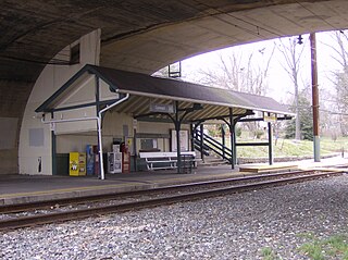
Spring Mill station is a suburban commuter railroad station on the SEPTA Manayunk/Norristown Line in Montgomery County, Pennsylvania. Its official address is Station Avenue near Hector Street, Conshohocken, but it is actually in the Spring Mill section of Whitemarsh Township. The station is located south of Hector Street, where North Lane deadends at the Schuylkill River.

Conshohocken station is a station located along the SEPTA Manayunk/Norristown Line. The station, located below Fayette Street, at Washington and Harry Streets in Conshohocken, Pennsylvania, includes a 95-space parking lot. In FY 2013, Conshohocken station had a weekday average of 646 boardings and 682 alightings.
Cynwyd station is a SEPTA Regional Rail station in Bala Cynwyd, Pennsylvania. Located at Conshohocken State Road and Bala Avenue, it is the last station along the Cynwyd Line. The station includes a 41-space parking lot.

This is a list of properties and districts listed on the National Register of Historic Places in Pennsylvania. As of 2015, there are over 3,000 listed sites in Pennsylvania. All 67 counties in Pennsylvania have listings on the National Register.

Matsonford station is a SEPTA rapid transit station in Lower Merion Township, Pennsylvania. It serves the Norristown High Speed Line and is located at Matsonford Road and Montgomery Avenue. All trains stop at Matsonford. The station lies 9.4 track miles from 69th Street Terminal. There is off-street parking available at this station, over the southwest corner of Matsonford & Montgomery. The tracks run above the southeast corner and bridges can be found over both streets. Until October 1995, the station was named Conshohocken Road.

Pennsylvania Route 320 is a north–south state highway in southeastern Pennsylvania. The southern terminus of the 18.8-mile (30.3 km) long route is at U.S. Route 13 /PA 291 in Chester. The northern terminus is at PA 23 in Swedeland. The route passes through suburban areas in Delaware and Montgomery counties to the west of Philadelphia, serving Swarthmore, Springfield, Broomall, Villanova, and Gulph Mills. PA 320 intersects many important highways including US 13 Business and Interstate 95 (I-95) in Chester, US 1 in Springfield, US 30 in Villanova, and I-76 in Gulph Mills. PA 320 runs parallel to I-476 for much of its length and crosses it four times. Even though there are no direct interchanges between I-476 and PA 320, several roads that intersect PA 320 provide access to I-476.

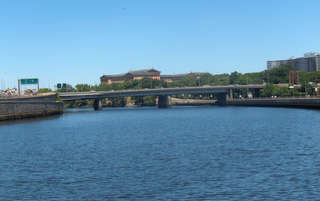
The Schuylkill River Trail is a multi-use trail along the banks of the Schuylkill River in southeastern Pennsylvania. Partially complete as of 2018, the trail is ultimately planned to run about 140 miles (230 km) from the river's headwaters in Schuylkill County to Fort Mifflin in Philadelphia.

Pennsylvania Route 23 is an 81.14-mile-long (130.58 km) state highway in southeastern Pennsylvania. The route begins at PA 441 in Marietta and heads east to U.S. Route 1 at City Avenue on the border of Lower Merion Township and Philadelphia. PA 23 begins at Marietta in Lancaster County and continues east to Lancaster, where it passes through the city on a one-way pair of streets and intersects US 222 and US 30.
The Battle of Matson's Ford was a battle in the Philadelphia campaign of the American Revolutionary War fought on December 11, 1777 in the area surrounding Matson's Ford. In this series of minor skirmish actions, advance patrols of Pennsylvania militia encountered a British foraging expedition and were overrun. The British pushed ahead to Matson's Ford, where units of the Continental Army were making their way across the Schuylkill River. The Americans retreated to the far side, destroying their temporary bridge across the Schuylkill. The British left the area the next day to continue foraging elsewhere; the Continentals crossed the river at Swede's Ford to Bridgeport, Pennsylvania, a few miles upriver from Matson's Ford.

The Pearl Harbor Memorial Bridge is a bridge that carries Interstate 476 (I-476) across the Schuylkill River between West Conshohocken and Connaughtown. Originally an unnamed bridge, Richard Tilghman, a state representative, proposed legislation to change the name of the bridge to commemorate the events that drew the United States into World War II. The bridge is notable for being in one of the most heavily-congested areas in the Philadelphia area. The bridge was chosen for the rename due to Conshohocken and West Conshohocken’s refusal to rename the Matsonford Bridge due to its important history.
The Vine Street Expressway Bridge is a bridge in Philadelphia, built in 1959 and reconstructed 1989 by the Pennsylvania Department of Transportation. It carries Interstate 676 over the Schuylkill River across CSX Transportation tracks and the North 24th Street ramp.
The Ten Mile Loop Expressway was a proposed expressway in 1947 by the Philadelphia City Planning Commission to build an expressway along the northern edge of the city of Philadelphia. It was to have started from the Delaware Expressway and ended at the Conshohocken Curve at Interstate 76.

Spring Mill is an unincorporated community in Whitemarsh Township, Montgomery County, Pennsylvania, United States.

The Norristown Branch is a railway line in Pennsylvania. It runs 14.6 miles (23.5 km) from a junction with the SEPTA Main Line in North Philadelphia to Norristown, Pennsylvania. It was originally built by the Philadelphia, Germantown and Norristown Railroad (PG&N) in 1834, and was a part of the Reading Company system from 1870 until 1976. Today it is owned by SEPTA and hosts the Manayunk/Norristown Line commuter rail service.
Butler Pike is a road in Montgomery County, Pennsylvania, that runs northeast from Conshohocken to Horsham Township. For most of its 9.8-mile (15.8 km) length, it is a county road and forms a boundary between townships.

