
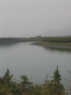
The Yukon River is a major watercourse of northwestern North America. The river's source is in British Columbia, Canada, from which it flows through the Canadian Yukon Territory. The lower half of the river lies in the U.S. state of Alaska. The river is 3,190 kilometres (1,980 mi) long and empties into the Bering Sea at the Yukon–Kuskokwim Delta. The average flow is 6,430 m3/s (227,000 ft3/s). The total drainage area is 832,700 km2 (321,500 mi2), of which 323,800 km2 (126,300 mi2) is in Canada. The total area is more than 25% larger than Texas or Alberta.

Plumas County is a county in the Sierra Nevada of California, United States. As of the 2010 census, the population was 20,007. The county seat is Quincy, and the only incorporated city is Portola. The largest community in the county is East Quincy. The county was named for the Spanish Río de las Plumas, which flows through the county.

The greater white-fronted goose is a species of goose related to the smaller lesser white-fronted goose. It is named for the patch of white feathers bordering the base of its bill, in fact albifrons comes from the Latin albus "white" and frons" forehead ". In Europe it has been known as the "white-fronted goose"; in North America it is known as the greater white-fronted goose, and this name is also increasingly adopted internationally. Even more distinctive are the salt-and-pepper markings on the breast of adult birds, which is why the goose is colloquially called the "specklebelly" in North America.

Denali is the highest mountain peak in North America, with a summit elevation of 20,310 feet (6,190 m) above sea level. With a topographic prominence of 20,156 feet (6,144 m) and a topographic isolation of 4,629 miles (7,450 km), Denali is the third most prominent and third most isolated peak on Earth, after Mount Everest and Aconcagua. Located in the Alaska Range in the interior of the U.S. state of Alaska, Denali is the centerpiece of Denali National Park and Preserve.

In geography, a sound is a large sea or ocean inlet, deeper than a bight and wider than a fjord; or a narrow sea or ocean channel between two bodies of land.

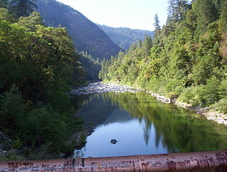
The Feather River is the principal tributary of the Sacramento River, in the Sacramento Valley of Northern California. The river's main stem is about 73 miles (117 km) long. Its length to its most distant headwater tributary is just over 210 miles (340 km). The main stem Feather River begins in Lake Oroville, where its four long tributary forks join together—the South Fork, Middle Fork, North Fork, and West Branch Feather Rivers. These and other tributaries drain part of the northern Sierra Nevada, and the extreme southern Cascades, as well as a small portion of the Sacramento Valley. The total drainage basin is about 6,200 square miles (16,000 km2), with approximately 3,604 square miles (9,330 km2) above Lake Oroville.

The Swanson River is a stream, 40 miles (64 km) long, on the Kenai Peninsula of south-central Alaska in the United States. Beginning at Gene Lake in the Swanson Lakes district, it flows southwest then north to Number Three Bay on the Gompertz Channel of Cook Inlet.

The Aniakchak River is a stream, 27 miles (43 km) long, in Lake and Peninsula Borough on the Alaska Peninsula in the United States. It arises in Surprise Lake in the crater of Mount Aniakchak, a volcano in the Aleutian Range. It flows eastward from Aniakchak National Monument and Preserve into Aniakchak Bay and the Pacific Ocean.

Beaver Creek is a 180-mile (290 km) tributary of the Yukon River in the U.S. state of Alaska. The creek begins at the confluence of Champion and Bear creeks in the White Mountains National Recreation Area, about 50 miles (80 km) north of Fairbanks. From there it flows west around the southern end of the White Mountains, then northeast into the Yukon Flats National Wildlife Refuge, then west into the Yukon River downstream of Beaver.

Birch Creek is a 150-mile (240 km) tributary of the Yukon River in the U.S. state of Alaska. Beginning at the confluence of Ptarmigan and Eagle creeks near Porcupine Dome, it flows southwest, then south under the Steese Highway and into the Steese National Conservation Area. It then turns east, then north, again passing under the Steese Highway and entering the Yukon Flats National Wildlife Refuge. Turning northwest, it ends where it splits into two distributaries, Lower Mouth Birch Creek and Upper Mouth Birch Creek, near Birch Creek, Alaska. The distributaries flow into the Yukon River at separate locations downstream of Fort Yukon.
The Chandalar River is a 100-mile (160 km) tributary of the Yukon River in the U.S. state of Alaska. Its peak flow, recorded by the United States Geological Survey (USGS) between 1964 and 1974 at a stream gauge at Venetie, was 62,800 cubic feet per second (1,780 m3/s) on June 9, 1968.
The Wind River is a tributary of the East Fork Chandalar River in the U.S. state of Alaska. It arises in the Philip Smith Mountains of the Brooks Range and flows into the East Fork and eventually into the Yukon River.

Chugach State Park covers 495,204 acres immediately east of the Anchorage Bowl in south-central Alaska. Though primarily in the Municipality of Anchorage, a small portion of the park north of the Eklutna Lake area in the vicinity of Pioneer Peak lies within the Matanuska-Susitna Borough. Established by legislation signed into law on August 6, 1970, by Alaska Governor Keith Miller, this state park was created to provide recreational opportunities, protect the scenic value of the Chugach Mountains and other geographic features, and ensure the safety of the water supply for Anchorage. The park, managed by Alaska State Parks, is the third-largest state park in the United States, and consists of geographically disparate areas each with different attractions and facilities. Only Anza-Borrego Desert State Park in California and Wood-Tikchik State Park in western Alaska are larger. Hunting and fishing are permitted in the Chugach under regulations established by the Alaska Department of Fish and Game for game management unit 14c. Target practice is not allowed within the park boundaries.
The Kokolik River is a stream, 200 miles (320 km) long, in the western North Slope of the U.S. state of Alaska. It rises in the De Long Mountains of the western Brooks Range and flows generally north and northwest into the Kasegaluk Lagoon. The river mouth is 1 mile (1.6 km) east of Point Lay, on the Chukchi Sea of the Arctic Ocean.
The North Fork Feather River is a watercourse of the northern Sierra Nevada in the U.S. state of California. It flows generally southwards from its headwaters near Lassen Peak to Lake Oroville, a reservoir formed by Oroville Dam in the foothills of the Sierra, where it runs into the Feather River. The river drains about 2,100 square miles (5,400 km2) of the western slope of the Sierras. By discharge, it is the largest tributary of the Feather.
The Wulik River is a stream, about 80 miles (130 km) long, in the northwestern part of the U.S. state of Alaska. Originating in the De Long Mountains in the North Slope Borough, it flows southwest to Kivalina Lagoon in the Chukchi Sea, east of Kivalina
The East Branch North Fork Feather River is a left tributary of the North Fork Feather River in the northern Sierra Nevada, Plumas County, California. Primarily within the Plumas National Forest, its course extends past Twain to near Belden.

Mount Ratz is a mountain located just west of the Stikine River, about 5 km (3 mi) east of the British Columbia-Alaska border. It is the highest peak in the Stikine Icecap and of the Boundary Ranges which in turn form part of the Coast Mountains. It is an extremely high-prominence summit, with a difference in elevation with its "key col" at Hyland Ranch Pass of 2,430 m (7,972 ft). Thus making it one of Canada's Ultra peaks.
Penny River is a waterway on the Seward Peninsula in the U.S. state of Alaska. There are several creek tributaries including Willow, Snowshoe and Homestake, from the west; and Quartz and Negsue from the east. Penny River enters Bering Sea a little east of the mouth of Cripple River, and has a drainage area of 36 square miles (93 km2)
Life Below Zero is a documentary television series which illustrates the daily and seasonal activities of subsistence hunters as they make their living in remote areas of Alaska. Produced by BBC Worldwide, the show airs on the National Geographic Channel.


