| Fedjefjorden | |
|---|---|
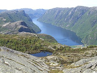
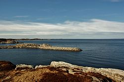
View of the fjord | |
 Fedjefjorden Location in Hordaland county | |
| Location | Hordaland county, Norway |
| Coordinates | 60°48′17″N4°43′57″E / 60.8048°N 4.7325°E Coordinates: 60°48′17″N4°43′57″E / 60.8048°N 4.7325°E |
| Basin countries | Norway |
| Max. length | 20 kilometres (12 mi) |
| Max. width | 5 kilometres (3.1 mi) |
Fedjefjorden is a fjord in Hordaland county, Norway. It is located in the municipalities of Fedje, Austrheim, and Øygarden. The fjord has a width of about 5 kilometres (3.1 mi) and extends about 20 kilometres (12 mi) from Holmengrå Lighthouse (at the northern end) to the island of Seløy (at the southern end) where it joins the Hjeltefjorden which flows further south towards Bergen. [1]

Geologically, a fjord or fiord is a long, narrow inlet with steep sides or cliffs, created by a glacier. There are many fjords on the coasts of Alaska, Antarctica, British Columbia, Chile, Greenland, the Faroe Islands, Iceland, Kamchatka, the Kerguelen Islands, New Zealand, Norway, Novaya Zemlya, Labrador, Nunavut, Newfoundland, Quebec, Scotland, South Georgia Island, and Washington state. Norway's coastline is estimated at 29,000 kilometres (18,000 mi) with nearly 1,200 fjords, but only 2,500 kilometres (1,600 mi) when fjords are excluded.

Hordaland is a county in Norway, bordering Sogn og Fjordane, Buskerud, Telemark, and Rogaland counties. Hordaland is the third largest county after Akershus and Oslo by population. The county government is the Hordaland County Municipality which is located in Bergen. Before 1972, the city of Bergen was its own separate county apart from Hordaland.

Norway, officially the Kingdom of Norway, is a Nordic country in Northwestern Europe whose territory comprises the western and northernmost portion of the Scandinavian Peninsula; the remote island of Jan Mayen and the archipelago of Svalbard are also part of the Kingdom of Norway. The Antarctic Peter I Island and the sub-Antarctic Bouvet Island are dependent territories and thus not considered part of the kingdom. Norway also lays claim to a section of Antarctica known as Queen Maud Land.
The fjord flows between several large islands and many small islets. The island of Fedje lies on the west side of the fjord and the islands of Fosnøyna and Radøy lie along the eastern side of the fjord. Just south of the island of Fedje, the fjord opens up westwards to the ocean through the 3.5-kilometre (2.2 mi) wide Fedjeosen. [2]

Fedje is the largest island in Fedje municipality in Hordaland county, Norway. The 7.2-square-kilometre (2.8 sq mi) island is home to almost all of the municipality's residents. The island sits west of the Fedjefjorden, south of the mouth of the Fensfjorden, and north of the islands of Øygarden. The North Sea lies to the west of the island. The main population center on the island is the village of Fedje on the northern coast of the island. The southern coast of the island is the site of the other village on the island, Stormark. The 47-metre (154 ft) tall Fedjebjørnen is the highest point on the mountain. Hellisøy Lighthouse lies just off the southwestern coast of the island.

Fosnøyna or Fosnøy is an island in the municipality of Austrheim in Hordaland county, Norway. The 26.3-square-kilometre (10.2 sq mi) island makes up the majority of the land area of the municipality. The island is located east of the Fedjefjorden and south of the Fensfjorden. The island of Radøy lies just south of Fosnøyna and the mainland of the Lindås peninsula lies immediately to the east of Fosnøyna. The highest point on the island is the 56-metre (184 ft) high Bredvikvarden. The island has some trees on it, but the northern part is fairly barren and rocky while the southern part is more marshy. There are two larger villages on the island: the village of Austrheim and the municipal centre of Årås. The island is connected to the mainland road network by two bridges. A series of small bridges connects Fosnøyna to the mainland of Lindås, west of Mongstad and the other connects the south end of Fosnøyna to the island of Radøy (which in turn is connected to the mainland.
Radøy is an island in Hordaland county, Norway. It is located east of Fedjefjorden and it is part of the municipalities of Radøy and Lindås. The island has an area of 110.7 square kilometres (42.7 sq mi), with only about 3.4 square kilometres (1.3 sq mi) being part of Lindås municipality. The highest point of the island is the 217-metre (712 ft) tall Morkefjellet.