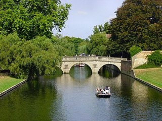
The River Cam is the main river flowing through Cambridge in eastern England. After leaving Cambridge, it flows north and east before joining the River Great Ouse to the south of Ely, at Pope's Corner. The total distance from Cambridge to the sea is about 40 mi (64 km) and is navigable for punts, small boats, and rowing craft. The Great Ouse also connects to England's canal system via the Middle Level Navigations and the River Nene. In total, the Cam runs for around 69 kilometres (43 mi) from its furthest source to its confluence with the Great Ouse.
The Car Dyke was, and to a large extent still is, an 85-mile (137 km) long ditch which runs along the western edge of the Fens in eastern England. It is generally accepted as being of Roman age and, for many centuries, to have been taken as marking the western edge of the Fens. There, the consensus begins to break down.

City Bridge is a crossing of the River Usk, for motor vehicles, cyclists and pedestrians, in the city of Newport, South Wales. It was opened in 2004 as part of the construction/re-generation of the Southern Distributor Road/A48 in Newport.

The A17 road is a mostly single carriageway road linking Newark-on-Trent in Nottinghamshire, England, to King's Lynn in Norfolk. It stretches for a distance of 62 miles travelling across the flat fen landscapes of southern Lincolnshire and western Norfolk and links the East Midlands with East Anglia. The road is notable for its numerous roundabouts and notoriously dangerous staggered junctions and also for its most famous landmark, the Cross Keys Bridge at Sutton Bridge close to the Lincolnshire/Cambridgeshire/Norfolk borders which carries the road over the River Nene.

The A1120 is an 'A' road in the English county of Suffolk. It links Stowmarket to Yoxford passing through the centre of the county. It is 26 miles (42 km) long.

Jesus Lock is a lock on the River Cam in the north of central Cambridge, England. This is Lock No. 1 on the navigable portion of the River Cam. It was built in 1836 and is the only lock in the city. Jesus Green Lock Cottage, the former lock-keeper's cottage, is by the lock on Jesus Green. It is owned by the Conservators of the River Cam and is rented out to students.

Trumpington Road is an arterial road in southeast central Cambridge, England. It runs between the junction of Trumpington Street and Lensfield Road at the northern end to the junction of the High Street in the village of Trumpington and Long Road at the southern end. The Fen Causeway leads off to the west near the northern end, over Coe Fen and the River Cam.
Magdalene Street is a street in the north of central Cambridge, England. It runs between Castle Street, by Castle Hill, at the junction with Northampton Street and Chesterton Lane, then Chesterton Road, to the northwest and Bridge Street at the junction with Thompson's Lane to the southeast.

Huntingdon Road is a major arterial road linking central Cambridge, England with Junction 14 of the M11 motorway and the A14 northwest from the city centre. The road is designated the A1307, follows the route of the Roman Via Devana, and is named after the town of Huntingdon, northwest of Cambridge.

Elizabeth Way is a road in northeast Cambridge, England. It is designated the A1134 and forms part of Cambridge's inner ring road. At the northern end is a roundabout forming a junction with Milton Road. Near the north end is another roundabout linking with Chesterton Road to the west. At the southern end there is a roundabout that links with East Road and Newmarket Road.

Newmarket Road is an arterial road in the east of Cambridge, England. It is designated the A1134 at the western end, linked by a roundabout forming a junction with Barnwell Road (A1134) to the south. The eastern end links with the city's inner ring road at another roundabout, with Elizabeth Way (A1134) to the north and East Road (A603) to the southeast. Newmarket Road continues a short way towards the city centre, becoming Maid's Causeway and then Jesus Lane. To the east, the road becomes the A1303 and crosses the A14 at a major roundabout, continuing further east and parallel to the A14 out of the city. The road is named after the market town of Newmarket in Suffolk, east of Cambridge.

Coe Fen is a semi-rural meadowland area to the east of the River Cam in the south of the city of Cambridge, England. It lies at the back of Peterhouse to the north, the Fitzwilliam Museum, and The Leys School to the south. The fen is straddled by the Fen Causeway across the Cam. There is also a footbridge at the back of The Leys School to the south and Crusoe Bridge is just north of the Fen Causeway Bridge.

Little Ponton is a village in the South Kesteven district of Lincolnshire, England. It lies 2 miles (3 km) south of Grantham, about 60 metres (200 ft) above sea level. Its population is included in that of the civil parish of Little Ponton and Stroxton.
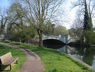
Fen Causeway is a link road in the city of Cambridge, United Kingdom, constructed in the mid-1920s to ease the pressure on Silver Street. It forms part of the A1134 ring road. It links Newnham Road and Trumpington Road and spans the River Cam with Sheep's Green to the south and Coe Fen to the north. There is little residential development on this road.

Ruleholme is a small hamlet on the A689 road and the River Irthing, near the village of Irthington, in the City of Carlisle district, in the English county of Cumbria. It is also near Carlisle Lake District Airport.

The River Granta is the name of two of the four tributaries of the River Cam, although both names are often used synonymously. The Granta starts near the village of Widdington in Essex, flowing north past Audley End House to merge with the other contributary Rhee, which is also commonly called River Cam, a mile south of Grantchester. From source to its confluence with the Rhee it is 41.7 kilometres (25.9 mi) in length.
The R622 road is a regional road in Ireland, located in County Cork.

Sheep's Green and Coe Fen is a 16.9 hectare Local Nature Reserve in Cambridge. It is owned and managed by Cambridge City Council.

Brasley Bridge or Trumpington Bridge is the first river Cam bridge on its upstream in Cambridge. It is located near Grantchester Road and connects Grantchester and Trumpington.

