List of bridges in Cambridge

Last updated

The following is a list and brief history of the bridges in Cambridge, England, principally those over the River Cam of which there are 25, soon to be 26.

Contents

The River Cam enters Cambridge from the south west of the city and heads north past many of the historic colleges of the University of Cambridge along the open area known as The Backs. After passing St John's College, it turns sharply and runs east, passing the weir at Jesus Green and the boathouses alongside Midsummer Common. Passing Chesterton, it turns north again and leaves the city, running a further 12 mi (19 km) before merging with the Great Ouse at Pope's Corner to the south of Ely.

Bridges over the River Cam (south to north)

Upper River (upstream of mill pond weir)

Trumpington Bridge (1790)

The most upstream bridge in Cambridge (UK Parliament constituency) lies along Grantchester Road between Grantchester and Trumpington. [1] Also known as Brasel Bridge, this 1790 brick bridge replaced a wooden bridge at the site of a ford. [2]

Sheep's Green Footbridge (1910)

Links Coe Fen behind The Leys School over a second small bridge to Lammas Land, near the area known as Hobson's Paradise. Also known as Sheep's Green bridge, it was closed in the second quarter of 2006 to replace the steps with ramps to make it easier for cyclists and prams to cross. The bridge decking was also replaced. map 1

Fen Causeway Bridge (1926)

The first road bridge that is reached as the river enters the city. The road was formally opened on 9 December 1926. [3] map 2

Crusoe Bridge (1898–99)

A steel footbridge with timber deck and supported on four cast-iron columns, [4] linking Sheep's Green and Coe Fen, and the final bridge on the 'Upper River' before it reaches the small weir at the mill pond. map 3

Middle River (between mill pond weir and Jesus Green weir)

Darwin College Bridges

Two wooden bridges within the college grounds connecting the main site with the college's two islands. map 4

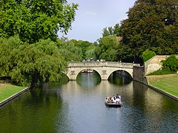
Silver Street Bridge (1958)

The site of bridges back to the 14th century, a cast iron bridge was built in 1843 but increasing heavy traffic led to a 1913 survey that determined the need for a new bridge. Repairs, however, allowed the bridge to last for a further 40 years. The present wide bridge, clad in Portland stone was designed by Sir Edwin Lutyens in 1932 and built in 1958–9. [5] map 5

Mathematical Bridge, Queens' College (1902)

The Mathematical Bridge Cambridge uni math bridge.JPG
The Mathematical Bridge

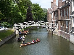
This is the third version of the design, first built in 1749. map 6

Cambridge University, Mathematical Bridge, Queen's College Cambridge University, Mathematical Bridge, Queen's College.jpg
Cambridge University, Mathematical Bridge, Queen's College

King's College Bridge (1819)

The first bridge on the site was built in the 15th century, but situated around 20 metres to the north, and was rebuilt several times before moving to the present incarnation in 1819, designed by William Wilkins and built by Francis Braidwood. map 7

Clare College Bridge (1640)

Clare College Bridge Clare Bridge 2003.jpg
Clare College Bridge

The oldest of Cambridge's current bridges, this bridge in classical style was built in 1639–40 by Thomas Grumbold (d.1659) [6] It is one of two bridges left standing by the Parliamentarian forces in the Civil War (the other being the Great Bridge, a wooden bridge which has since been destroyed) when Cromwell used the stone from other bridges to refortify Cambridge Castle. Many different stories are told to explain the missing section of the globe second from the left on the south side of the bridge. One rumour is that the builder of the bridge received (what he considered to be) insufficient payment, and in his anger, removed a segment of the globe; another is that complete bridges were subject to a tax at the time it was built, and the missing segment made the bridge incomplete and hence untaxed. map 8

Cambridge University, Bridge, Clare College Cambridge University, Bridge, Clare College.jpg
Cambridge University, Bridge, Clare College

Garret Hostel Bridge (1960)

At least the eighth bridge on this site on Garret Hostel Lane between the colleges of Trinity and Trinity Hall. The current design is by Timothy Guy Morgan, who at the time was an undergraduate student at Jesus College, after an open competition. Morgan died in 1960, before the bridge was completed. It was one of the first post-tensioned concrete bridges in the country. map 9 Known to students locally as “orgasm bridge”. [7]

Trinity College Bridge (1764)

Designed by James Essex, it replaced a stone bridge built in 1651, which in turn replaced a stone bridge pulled down in 1643 by Cromwellian soldiers as a defence during the English Civil War. map 10 It is a Grade I listed building. [8]

Cambridge University, Trinity Bridge Cambridge University, Trinity Bridge.jpg
Cambridge University, Trinity Bridge
Cambridge University, Bridge, Trinity College Cambridge University, Bridge, Trinity College.jpg
Cambridge University, Bridge, Trinity College

Kitchen Bridge, St John's College (1709–11)

Cambridge University, St. John's College from Kitchen Bridge with the Bridge of Sighs to the right Cambridge University, St. John's College from Kitchen Bridge with the Bridge of Sighs to the right.jpg
Cambridge University, St. John's College from Kitchen Bridge with the Bridge of Sighs to the right

Also known as St John's Old Bridge. [9] The second oldest of Cambridge's remaining bridges, built by Robert Grumbold (1639–1720) according to designs by Sir Christopher Wren. The bridge was crafted from a single block of limestone, carved to give the appearance of masonry. map 11

Bridge of Sighs, St John's College (1831)

The Bridge of Sighs Bridge of Sighs, Cambridge.JPG
The Bridge of Sighs

Also known as New Court Bridge, [9] it is probably Cambridge's best-known bridge, designed by Henry Hutchinson and based on a similarly named bridge in Venice, although the only real similarity between them is that they are both covered bridges over waterways. map 12 . A bridge in Oxford, also nicknamed "The Bridge of Sighs" but more reminiscent of the Rialto Bridge, links two sites of Hertford College, but it bridges New College Lane rather than a river or canal.

Magdalene Bridge (1823)

Magdalene Bridge viewed from the boardwalk near Quayside, with the tower of St John's College New Court in the background. Cambridge Quayside Magdalene Bridge.jpg
Magdalene Bridge viewed from the boardwalk near Quayside, with the tower of St John's College New Court in the background.

Named after Magdalene College, which stands nearby. It is very close to the location of the Roman ford (around 50 AD), and the location of the first Roman bridge in Cambridge (probably re-built by Offa in the 8th century). map 13

The latest bridge was designed by Arthur Browne in Gothic revival style and was rebuilt in the same style in 1982.

Lower River (downstream of Jesus Green weir)

Jesus Lock footbridge (1892)

An iron bridge over the weir that divides the 'Middle River' from the 'Lower River', where punting gives way to rowing. map 14

Victoria Bridge (1890)

Allowed the residents of Chesterton easy access to the city for the first time. The foundation stone was laid by Frederic Wace, mayor of Cambridge, on 4 November 1889 and the bridge was officially opened by Wace on 11 December 1890. [3] The bridge was rebuilt for strengthening in 1992. map 15

Fort St George footbridge, Midsummer Common (1927)

Named after the Fort St George pub near its southern end, the site was previously home to a ferry that was "probably the busiest of all the river crossings, running from 8 a.m. to 10 p.m". [10] The bridge was built in 1927, and is now open for use by cyclists. map 16

Cutter Ferry Bridge (2005)

A pedestrian and cycle bridge that links Cutter Ferry Lane with Midsummer Common. The original footbridge was closed in 2003 after over 75 years of service, and removed during December 2004. The replacement, over which cyclists may legally cycle, was opened on 20 May 2005. map 17

Also known by Cambridge residents as Pye's Bridge because of the one-time nearby Pye electronics factory, and by student rowers as Emma Bridge because of its proximity to Emmanuel College Boathouse. [11]

Elizabeth Way Bridge (1971)

A plain four-lane concrete road bridge, opened by Lord Butler in his capacity as High Steward of Cambridge on 13 July 1971, [3] this is Cambridge's most recent road bridge. The opening caused a few minutes of embarrassment when Lord Butler's golden scissors failed to cut the ribbon across the road. map 18 The bridge forms part of Elizabeth Way (A1134).

Equiano Bridge (formerly Riverside Bridge) (2008)

Equiano Bridge Cambridge Riverside Bridge.jpg
Equiano Bridge

This foot and cycle bridge connects Chesterton and Riverside near the Museum of Technology. [12] Construction work began in April 2007, and the bridge opened to the public on 5 June 2008. [13] It cost £3.1 million and was partially funded by Tesco to provide increased access to its Newmarket Road store. [14] In 2022 it was renamed to honour writer and abolitionist Olaudah Equiano who had links to the Cambridge area. [15] map 18a

Green Dragon bridge, Stourbridge Common (1935)

Named after the Green Dragon pub opposite its northern end, the iron-arch bridge was built in 1935, causing the closure of the nearby Horse Grind and Pike & Eel ferries. [16] Also known to student rowers as 'Chesterton Footbridge' as it crosses over what they know as 'Chesterton Corner'. map 19

Railway Bridge

Crosses the river through east Chesterton, south of the A14 bridge. It is the third railway bridge to be built on this site, replacing a plain plate girder bridge which stood on the site between 1870 and 1930, which itself replaced a wooden bridge built in 1846. map 20

Abbey-Chesterton Bridge (2021)

The Abbey-Chesterton foot and cycle bridge in front of the railway bridge Cmglee Cambridge Chisholm Trail bridge south.jpg
The Abbey-Chesterton foot and cycle bridge in front of the railway bridge

The Abbey-Chesterton Bridge was installed on 8 November 2020 [17] at Ditton Meadows, [18] [19] immediately downstream (east) of the railway girder bridge. This bridge carries the Chisholm Trail over the River Cam. Estimated cost is £4.5 million. The Abbey-Chesterton Bridge was opened by Jim Chisholm at 13:30 on 23 December 2021. [20] map 20a

A14 Bridge

Known (incorrectly) to rowers and others as the "Motorway Bridge". Built as part of the 'Cambridge northern bypass', which opened in 1977, [21] the bridge crosses the river just south of Baits Bite Lock. This bridge is also sometimes referred to as “Bovis Bridge” or "Newnham Bridge". map 21

Footbridge over the weir, Baits Bite Lock

An elevated footbridge crosses Baits Bite Lock in Milton to a narrow islet. A concrete-arch footbridge then crosses the weir to the east bank near Horningsea. map 22

Other bridges

Deck of Jane Coston cycle bridge between Milton and Cambridge. Jane Coston cycle bridge deck.jpg
Deck of Jane Coston cycle bridge between Milton and Cambridge.

See also

Mapping

Related Research Articles

<span class="mw-page-title-main">River Cam</span> Tributary of the River Great Ouse

The River Cam is the main river flowing through Cambridge in eastern England. After leaving Cambridge, it flows north and east before joining the River Great Ouse to the south of Ely, at Pope's Corner. The total distance from Cambridge to the sea is about 40 mi (64 km) and is navigable for punts, small boats, and rowing craft. The Great Ouse also connects to England's canal system via the Middle Level Navigations and the River Nene. In total, the Cam runs for around 69 kilometres (43 mi) from its furthest source to its confluence with the Great Ouse.

<span class="mw-page-title-main">River Don, Yorkshire</span> River in South Yorkshire and the East Riding of Yorkshire, England

The River Don is a river in South Yorkshire and the East Riding of Yorkshire, England. It rises in the Pennines, west of Dunford Bridge, and flows for 69 miles (111 km) eastwards, through the Don Valley, via Penistone, Sheffield, Rotherham, Mexborough, Conisbrough, Doncaster and Stainforth. It originally joined the Trent, but was re-engineered by Cornelius Vermuyden as the Dutch River in the 1620s, and now joins the River Ouse at Goole. Don Valley is a UK parliamentary constituency near the Doncaster stretch of the river.

<span class="mw-page-title-main">Chesterton, Cambridge</span> Human settlement in England

Chesterton is a suburb in the northeast corner of Cambridge, in the Cambridge district, in the county of Cambridgeshire, England, 2 miles (3.2 km) north of Cambridge station, on the north bank of the River Cam.

<span class="mw-page-title-main">River Cole, West Midlands</span> River in the English Midlands

The River Cole is a 25 miles (40 km) river in the English Midlands. It rises on the lower slopes of Forhill, one of the south-western ramparts of the Birmingham Plateau, at Red Hill and flows south before flowing largely north-east across the plateau to enter the River Blythe below Coleshill, near Ladywalk, shortly before the Blythe meets the Tame. This then joins the Trent, whose waters reach the North Sea via the Humber Estuary. Its source is very near the main watershed of Midland England: tributaries are few and very short except in the lower reaches, so the Cole is only a small stream.

<span class="mw-page-title-main">River Dee, Wales</span> River in Wales and England

The River Dee is a river flowing through North Wales, and through Cheshire, England, in Great Britain. The length of the main section from Bala to Chester is 113 km and it is largely located in Wales. The stretch between Aldford and Chester is within England, and two other sections form the border between the two countries.

<span class="mw-page-title-main">Taff Trail</span> Walking and cycling track in South Wales

The Taff Trail is a walking and cycle path that runs for 55 miles (89 km) between Cardiff Bay and Brecon in Wales. It is so named because it follows the course of the River Taff. Along much of its length, it follows the National Cycle Network Route 8 that continues to Holyhead, and is substantially off-road.

<span class="mw-page-title-main">River Lymn</span> River in Lincolnshire, England

The River Lymn is a river in Lincolnshire, England. It rises in the Wolds on the eastern slope of Castcliffe Hill in Fulletby parish. It flows south-eastwards to the Lincolnshire Marsh, where it becomes known as the Steeping River on the boundary of Great Steeping parish. The main channel is supplemented by the Wainfleet Relief Channel as it passes Wainfleet All Saints, and the relief channel is joined by the old course of the Lymn. Once the two channels rejoin, there are three flood defence structures to protect the region from flooding by the North Sea.

<span class="mw-page-title-main">Milton, Cambridgeshire</span> Human settlement in England

Milton is a village just north of Cambridge, England, with a population of 4,679 at the 2011 census.

<span class="mw-page-title-main">Hollinwood Branch Canal</span>

The Hollinwood Branch Canal was a canal near Hollinwood, in Oldham, England. It left the main line of the Ashton Canal at Fairfield Junction immediately above lock 18. It was just over 4.5 miles (7.2 km) long and went through Droylsden and Waterhouses to terminate at Hollinwood Basin. It rose through four locks at Waterhouses (19–22) and another four at Hollinwood (23–26). Immediately above lock 22 at Waterhouses was Fairbottom Junction where the Fairbottom Branch Canal started. Beyond Hollinwood Basin there was a lock free private branch, known as the Werneth Branch Canal, to Old Lane Colliery, which opened in 1797. It is a biological Site of Special Scientific Interest and a Local Nature Reserve.

<span class="mw-page-title-main">Lea Valley Walk</span> Long-distance footpath in South East England

The Lea Valley Walk is a 50-mile (80 km) long-distance path located between Leagrave, the source of the River Lea near Luton, and the Thames, at Limehouse Basin, Limehouse, east London. From its source much of the walk is rural. At Hertford the path follows the towpath of the River Lee Navigation, and it becomes increasingly urbanised as it approaches London. The walk was opened in 1993 and is waymarked throughout using a swan logo.

<span class="mw-page-title-main">River Don Navigation</span> Waterway navigation in South Yorkshire, England

The River Don Navigation was the result of early efforts to make the River Don in South Yorkshire, England, navigable between Fishlake and Sheffield. The Dutch engineer Cornelius Vermuyden had re-routed the mouth of the river in 1626, to improve drainage, and the new works included provision for navigation, but the scheme did not solve the problem of flooding, and the Dutch River was cut in 1635 to link the new channel to Goole. The first Act of Parliament to improve navigation on the river was obtained in 1726, by a group of Cutlers based in Sheffield; the Corporation of Doncaster obtained an Act in the following year for improvements to the lower river. Locks and lock cuts were built and by 1751 the river was navigable to Tinsley.

National Cycle Route 51 is an English long distance cycle route running broadly east-west connecting Colchester and the port of Harwich to Oxford via Ipswich, Bury St Edmunds, Cambridge, Bedford, Milton Keynes, Bicester, and Kidlington.

National Cycle Route 23 is a route of the National Cycle Network, running from Reading to Sandown. The partially signed route passes through Basingstoke, Eastleigh and Southampton; once across the Solent, it continues through Cowes and Newport.

<span class="mw-page-title-main">Main Yarra Trail</span>

The Main Yarra Trail, also known as the Yarra Trail is a shared-use path for cyclists and pedestrians, which follows the Yarra River through the northeastern suburbs of Melbourne, Victoria, Australia.

<span class="mw-page-title-main">Jesus Lock</span>

Jesus Lock is a lock on the River Cam in the north of central Cambridge, England. This is Lock No. 1 on the navigable portion of the River Cam. It was built in 1836 and is the only lock in the city. Jesus Green Lock Cottage, the former lock-keeper's cottage, is by the lock on Jesus Green. It is owned by the Conservators of the River Cam and is rented out to students.

<span class="mw-page-title-main">Elizabeth Way, Cambridge</span>

Elizabeth Way is a road in northeast Cambridge, England. It is designated the A1134 and forms part of Cambridge's inner ring road. At the northern end is a roundabout forming a junction with Milton Road. Near the north end is another roundabout linking with Chesterton Road to the west. At the southern end there is a roundabout that links with East Road and Newmarket Road.

<span class="mw-page-title-main">Transport in Cambridge</span> Overview of the transport in Cambridge

Cambridge is a university town and the administrative centre of the county of Cambridgeshire, England. It lies in East Anglia about 50 miles (80 km) north of London. Its main transport links are the M11 road to London, the A14 east–west road and the West Anglia Main Line railway line to London.

<span class="mw-page-title-main">Upper Don Trail</span>

The Upper Don Trail formerly known as the Upper Don Walk is a 15 mile long recreational multi use trail which links the centre of Sheffield to the village of Oughtibridge with various sections continuing out towards Stocksbridge and Langsett Reservoir. It follows the course of the River Don and partially the National Cycle Network route 627. The route is variable in quality, the first mile is well defined as it has been integrated into the newly developed quarters to the immediate north of the city centre. The rest of the route is a mixture of path, road and woodland walking.

<span class="mw-page-title-main">Chisholm Trail (Cambridge)</span> Walking and cycling route in Cambridge

The Chisholm Trail is a walking and cycling route in Cambridge, England. It will link Addenbrooke's Hospital and the Biomedical Campus in the south to Cambridge North railway station and the business and science parks. It will also connect with the Guided Busway and the National Cycle Network. Once completed, the trail will provide a 26 kilometre route from Trumpington to St Ives. The route follows current and former rail infrastructure and largely avoids conflicts with car traffic. It includes the new Abbey Chesterton bridge for bicycles and pedestrians across the River Cam, installed in November 2020.

References

  1. OpenStreetMap: Trumpington Ward
  2. S.P. Widnall, A History of Grantchester in the County of Cambridge, pages 23 and 120
  3. 1 2 3 Plaque on bridge
  4. Cambridge Historic Core Appraisal - June 2006 - Coe Fen / Sheep’s Green
  5. "Silver Street Bridge". Historic England.
  6. About Clare: History from Clare College's website, retrieved 25 June 2007
  7. Cox, Genevieve (24 September 2015). "How Cambridge got its name". Varsity Online. Retrieved 7 May 2018.
  8. "Name: TRINITY COLLEGE, TRINITY BRIDGE List entry Number: 1331804". Historic England. Retrieved 13 April 2017.
  9. 1 2 Ordnance Survey. OS Maps Online (Map). 1:25,000. Leisure. Retrieved 8 January 2021.
  10. "Fort St George". Capturing Cambridge.
  11. Image of Cutter Ferry Bridge
  12. People power is needed at bridge | Cambridge News | Latest News Headlines From Cambridge City & Cambridgeshire | National News | Cambridge News Archived 14 July 2014 at the Wayback Machine
  13. "Riverside foot and cycle bridge". Cambridgeshire County Council. Archived from the original on 18 April 2008. Retrieved 5 June 2008.
  14. "Tale of Two Bridges". Geoff Jones. 5 June 2008. Retrieved 6 June 2012.
  15. "City bridge to be renamed after writer and abolitionist Olaudah Equiano". Cambridge Independent. Cambridge. 27 October 2022. ISSN   2398-8959 . Retrieved 28 October 2022.
  16. Chris Howes (2021). The River Great Ouse and its tributaries. Imray, Laurie, Norie and Wilson Ltd.
  17. "Work begins on The Chisholm Trail & Abbey-Chesterton Bridge after contracts awarded". Greater Cambridge Partnership. Retrieved 4 May 2020.
  18. "How the £13m Chisholm Trail will revolutionise Cambridge cycling". Archived from the original on 15 July 2015. Retrieved 15 July 2015.
  19. "Abbey-Chesterton Bridge on the Chisholm Trail" (PDF). Cambridge Cycling Campaign. January 2015.
  20. Gardner, Gemma (23 December 2021). "First stage of Chisholm Trail walking and cycling route across Cambridge opens". Cambridge Independent. Milton : Iliffe Media Ltd. ISSN   2398-8959. OCLC   1064919081 . Retrieved 30 December 2021.
  21. "Girton Interchange". Sabre Roads.
  22. "Jane Coston Cycle bridge : a model for managing vibration". Proceedings of the Institution of Civil Engineers. 2006.
  23. "Jane Coston Cycle Bridge, Milton".
  24. "Newsletter 56". Cambridge Cycling Campaign.