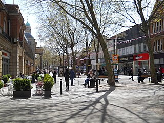
Peterborough is a cathedral city in the City of Peterborough district in the ceremonial county of Cambridgeshire, England. The city is 74 miles (119 km) north of London, on the River Nene. As of the 2021 census, Peterborough had a population of 192,178, while the population of the district was 215,673.

Cambridge is a city and non-metropolitan district in the county of Cambridgeshire, England. It is the county town of Cambridgeshire and is located on the River Cam, 55 miles (89 km) north of London. As of the 2021 United Kingdom census, the population of the City of Cambridge was 145,700; the population of the wider built-up area was 181,137. Cambridge became an important trading centre during the Roman and Viking ages, and there is archaeological evidence of settlement in the area as early as the Bronze Age. The first town charters were granted in the 12th century, although modern city status was not officially conferred until 1951.
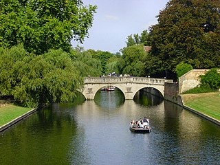
The River Cam is the main river flowing through Cambridge in eastern England. After leaving Cambridge, it flows north and east before joining the River Great Ouse to the south of Ely, at Pope's Corner. The total distance from Cambridge to the sea is about 40 mi (64 km) and is navigable for punts, small boats, and rowing craft. The Great Ouse also connects to England's canal system via the Middle Level Navigations and the River Nene. In total, the Cam runs for around 69 kilometres (43 mi) from its furthest source to its confluence with the Great Ouse.
Burwell is a village and civil parish in Cambridgeshire, England, some 10 miles north-east of Cambridge. It lies on the south-east edge of the Fens. Westward drainage is improved by Cambridgeshire lodes (waterways), including Burwell Lode, a growth factor in the village. A population of 6,309 in the 2011 census was put at 6,417 in 2019.

Hughes Hall is a constituent college of the University of Cambridge in England. It is the oldest of the University of Cambridge's postgraduate colleges. The college also admits undergraduates, though undergraduates admitted by the college must be aged 21 or over. There is no age requirement for postgraduate students. The majority of Hughes Hall students are postgraduate, although nearly one-fifth of the student population comprises individuals aged 21 and above who are studying undergraduate degree courses at the university.

The A14 is a major trunk road in England, running 127 miles (204 km) from Catthorpe Interchange, a major intersection at the southern end of the M6 and junction 19 of the M1 in Leicestershire to the Port of Felixstowe, Suffolk. The road forms part of the unsigned Euroroutes E24 and E30. It is the busiest shipping lane in East Anglia carrying anything from cars to large amounts of cargo between the UK and Mainland Europe.
Fen Causeway or the Fen Road is the modern name for a Roman road of England that runs between Denver, Norfolk in the east and Peterborough in the west. Its path covers 24 miles (39 km), passing March and Eldernell before joining the major Roman north–south route Ermine Street west of modern-day Peterborough. It provided a link from the north and west of England to East Anglia.

Chatteris is a market town and civil parish in the Fenland district of Cambridgeshire, England, situated in the Fens between Huntingdon, March and Ely. The town is in the North East Cambridgeshire parliamentary constituency.

Waterbeach railway station is on the Fen line in the east of England, serving the village of Waterbeach, Cambridgeshire. It is 61 miles 1 chain (98.2 km) measured from London Liverpool Street and 63 miles 29 chains (102 km) from London King's Cross; it is situated between Cambridge North and Ely stations. Its three-letter station code is WBC.

Wicken Fen is a 254.5-hectare (629-acre) biological Site of Special Scientific Interest west of Wicken in Cambridgeshire. It is also a National Nature Reserve, and a Nature Conservation Review site. It is protected by international designations as a Ramsar wetland site of international importance, and part of the Fenland Special Area of Conservation under the Habitats Directive.

Shippea Hill railway station is on the Breckland Line in the east of England, serving the Burnt Fen area of Cambridgeshire and Suffolk. The line runs between Cambridge in the west and Norwich in the east.

Hobson's Conduit, also called Hobson's Brook, is a watercourse that was built from 1610 to 1614 by Thomas Hobson and others to bring fresh water into the city of Cambridge, England from springs at Nine Wells, a Local Nature Reserve, near the village of Great Shelford. It is now a Scheduled Ancient Monument and historical relic. The watercourse currently runs overground until Cambridge University Botanic Garden and Brookside, where it is at its widest. At the corner of Lensfield Road stands a hexagonal monument to Hobson, which once formed part of the market square fountain, and was moved to this location in 1856, after a fire in the Market. The flow of water runs under Lensfield Road, and subsequently runs along both sides of Trumpington Street in broad gutters towards Peterhouse and St Catharine's College, and also St Andrew's Street. The conduit currently ends at Silver Street.

Little Thetford is a small village in the civil parish of Thetford, 3 miles (5 km) south of Ely in Cambridgeshire, England, about 76 miles (122 km) by road from London. The village is built on a boulder clay island surrounded by flat fenland countryside, typical of settlements in this part of the East of England.
Cambridge North railway station is a railway station located in northern Cambridge, immediately adjacent to the suburb of Chesterton, close to Cambridge Science Park. The station is on the Fen Line, which runs from Cambridge to King's Lynn. It connects to the Cambridgeshire Guided Busway, and provides an interchange with Park & Ride and local bus services.

Trumpington Road is an arterial road in southeast central Cambridge, England. It runs between the junction of Trumpington Street and Lensfield Road at the northern end to the junction of the High Street in the village of Trumpington and Long Road at the southern end. The Fen Causeway leads off to the west near the northern end, over Coe Fen and the River Cam.

Jesus Lane is a street in central Cambridge, England. The street links with the junction of Bridge Street and Sidney Street to the west. To the east is a roundabout. To the south is King Street, running parallel with Jesus Lane and linking at the roundabout. The road continues east as Maid's Causeway and then Newmarket Road east out of Cambridge. To the north is Victoria Avenue between Jesus Green to the west and Midsummer Common to the east. Also to the north near the western end is Park Street, location of the ADC Theatre. To the south is Short Street, quickly leading into Emmanuel Road past Christ's Pieces.
Magdalene Street is a street in the north of central Cambridge, England. It runs between Castle Street, by Castle Hill, at the junction with Northampton Street and Chesterton Lane, then Chesterton Road, to the northwest and Bridge Street at the junction with Thompson's Lane to the southeast.

Newmarket Road is an arterial road in the east of Cambridge, England. It is designated the A1134 at the western end, linked by a roundabout forming a junction with Barnwell Road (A1134) to the south. The eastern end links with the city's inner ring road at another roundabout, with Elizabeth Way (A1134) to the north and East Road (A603) to the southeast. Newmarket Road continues a short way towards the city centre, becoming Maid's Causeway and then Jesus Lane. To the east, the road becomes the A1303 and crosses the A14 at a major roundabout, continuing further east and parallel to the A14 out of the city. The road is named after the market town of Newmarket in Suffolk, east of Cambridge.

Coe Fen is a semi-rural meadowland area to the east of the River Cam in the south of the city of Cambridge, England. It lies at the back of Peterhouse to the north, the Fitzwilliam Museum, and The Leys School to the south. The fen is straddled by the Fen Causeway across the Cam. There is also a footbridge at the back of The Leys School to the south and Crusoe Bridge is just north of the Fen Causeway Bridge.

Sheep's Green and Coe Fen is a 16.9 hectare Local Nature Reserve in Cambridge. It is owned and managed by Cambridge City Council.

