The River Cam is the main river flowing through Cambridge in eastern England. After leaving Cambridge, it flows north and east before joining the River Great Ouse to the south of Ely, at Pope's Corner. The total distance from Cambridge to the sea is about 40 mi (64 km) and is navigable for punts, small boats, and rowing craft. The Great Ouse also connects to England's canal system via the Middle Level Navigations and the River Nene. In total, the Cam runs for around 69 kilometres (43 mi) from its furthest source to its confluence with the Great Ouse.
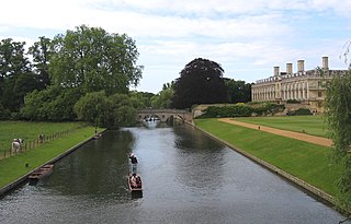
The Backs is a picturesque area to the east of Queen's Road in the city of Cambridge, England, where several colleges of the University of Cambridge back on to the River Cam with their grounds covering both banks of the river.

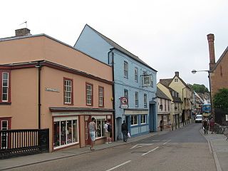
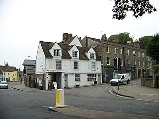
King Street is a street in central Cambridge, England. It connects between Sussex Street heading west and Hobson Street heading south at the western end and a large roundabout to the east. It runs parallel to and south of Jesus Lane. The roads link together at a roundabout at the eastern end. To the east is Maid's Causeway and then Newmarket Road leading out of Cambridge. To the north is Victoria Avenue between Jesus Green and Midsummer Common. To the south is Short Street, Cambridge, quickly leading into Emmanuel Road past Christ's Pieces.
Ring Road is a 4 lane controlled access highway in Regina, Saskatchewan, Canada. Ring Road is a partial ring road or beltway that forms a partial circle around Regina, bypasses the city on the north, east, and south sides, with Lewvan Drive and Pasqua Street N functioning as the de facto western leg. East of Pasqua Street, Ring Road continues west as 9th Avenue N, an arterial road. Ring Road has a speed limit of 100 km/h (60 mph) and consists of 13 interchanges.

Jesus Green Swimming Pool is a lido situated on Jesus Green in Cambridge, England. Opened in 1923, it is one of the few remaining examples of the lidos built across the country in the 1920s — open air pools with space for activities other than swimming. Unusually, the pool is significantly longer than it is wide — this was a design idea to mimic swimming in the nearby river. It opens for public bathing every day from May to September each year, and remains open but operates reduced hours over the winter period.

Duroliponte or Durolipons was a small town in the Roman province of Britannia on the site of what is now the city of Cambridge.
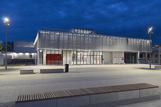
Cambridge North railway station is a railway station located in the Cambridge suburb of Chesterton, close to Cambridge Science Park. The station is on the Fen Line, which runs from Cambridge to King's Lynn. It connects to the Cambridgeshire Guided Busway, and provides an interchange with Park & Ride and local bus services.

Jesus Lock is a lock on the River Cam in the north of central Cambridge, England. This is Lock No. 1 on the navigable portion of the River Cam. It was built in 1836 and is the only lock in the city. Jesus Green Lock Cottage, the former lock-keeper's cottage, is by the lock on Jesus Green. It is owned by the Conservators of the River Cam and is rented out to students.
Jesus Green is a park in the north of central Cambridge, Cambridgeshire, England, north of Jesus College. Jesus Ditch runs along the southern edge Jesus Green. On the northern edge of Jesus Green is the River Cam, with Chesterton Road on the opposite side. To the east is Victoria Avenue and beyond that Midsummer Common, common land that is still used for grazing. Victoria Avenue crosses the Cam at Victoria Bridge, connecting to Chesterton Road, at the northeastern corner of Jesus Green.

Madingley Road is a major arterial road linking central Cambridge, England with Junction 13 of the M11 motorway. It passes by West Cambridge, a major new site where some University of Cambridge departments are being relocated.

Jesus Lane is a street in central Cambridge, England. The street links with the junction of Bridge Street and Sidney Street to the west. To the east is a roundabout. To the south is King Street, running parallel with Jesus Lane and linking at the roundabout. The road continues east as Maid's Causeway and then Newmarket Road east out of Cambridge. To the north is Victoria Avenue between Jesus Green to the west and Midsummer Common to the east. Also to the north near the western end is Park Street, location of the ADC Theatre. To the south is Short Street, quickly leading into Emmanuel Road past Christ's Pieces.
Magdalene Street is a street in the north of central Cambridge, England. It runs between Castle Street, by Castle Hill, at the junction with Northampton Street and Chesterton Lane, then Chesterton Road, to the northwest and Bridge Street at the junction with Thompson's Lane to the southeast.

Queen's Road is a major road to the west of central Cambridge, England. It links with Madingley Road and Northampton Street to the north with Sidgwick Avenue, Newnham Road and Silver Street to the south.

Northampton Street is a street in the north of central Cambridge, England. It runs between Madingley Road and Queen's Road to the west and Castle Street, by Castle Hill, Chesterton Lane, and Magdalene Street to the east.
Castle Street is a street in the north of central Cambridge, England. To the southeast is a junction with Northampton Street, Magdalene Street, and Chesterton Lane. To the northwest is a junction with Mount Pleasant, Huntingdon Road, Histon Road, and Victoria Road.

Chesterton Road is a road in the north of Cambridge, England.

Elizabeth Way is a road in northeast Cambridge, England. It is designated the A1134 and forms part of Cambridge's inner ring road. At the northern end is a roundabout forming a junction with Milton Road. Near the north end is another roundabout linking with Chesterton Road to the west. At the southern end there is a roundabout that links with East Road and Newmarket Road.

Newmarket Road is an arterial road in the east of Cambridge, England. It is designated the A1134 at the western end, linked by a roundabout forming a junction with Barnwell Road (A1134) to the south. The eastern end links with the city's inner ring road at another roundabout, with Elizabeth Way (A1134) to the north and East Road (A603) to the southeast. Newmarket Road continues a short way towards the city centre, becoming Maid's Causeway and then Jesus Lane. To the east, the road becomes the A1303 and crosses the A14 at a major roundabout, continuing further east and parallel to the A14 out of the city. The road is named after the market town of Newmarket in Suffolk, east of Cambridge.

Victoria Road is a residential road in the north of Cambridge, England. The road is designated the A1134. At the western end, the road links with Histon Road, Huntingdon Road, Mount Pleasant, and Castle Street.In 1950, there were plans to improve this junction, but they never came to fruition. At the eastern end it links with Chesterton Road (A1303) and also links to Milton Road, the A1134, then A1309, northeast out of the city, also linking with the A14.

