
Cambridge is a university city and the county town of Cambridgeshire, United Kingdom, on the River Cam approximately 55 miles (89 km) north of London. At the United Kingdom Census 2011, the population of the Cambridge built-up area was 158,434 including 29,327 students. Cambridge became an important trading centre during the Roman and Viking ages, and there is archaeological evidence of settlement in the area as early as the Bronze Age. The first town charters were granted in the 12th century, although modern city status was not officially conferred until 1951.
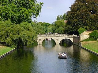
The River Cam is the main river flowing through Cambridge in eastern England. After leaving Cambridge, it flows north and east into the Great Ouse to the south of Ely at Pope's Corner. The Great Ouse connects the Cam to the North Sea at King's Lynn: The total distance from Cambridge to the sea is about 40 mi (64 km) and is navigable for punts, small boats, and rowing craft. The Great Ouse also connects to England's canal system via the Middle Level Navigations and the River Nene. In total, the Cam runs for around 69 kilometres (43 mi) from its furthest source to its confluence with the Great Ouse.

Grantchester is a village and civil parish on the River Cam or Granta in South Cambridgeshire, England. It lies about two miles (3 km) south of Cambridge.

Crickhowell is a town and community in southeastern Powys, Wales, near Abergavenny, and is in the historic county of Brecknockshire.

Mablethorpe is a seaside town in the East Lindsey district of Lincolnshire, England, part of the civil parish of Mablethorpe and Sutton. The population including nearby Sutton-on-Sea was 12,531 at the 2011 census and estimated at 12,633 in 2019. The town was visited regularly by Alfred, Lord Tennyson, a 19th-century Poet Laureate of the United Kingdom. Some town features have been named after him, such as Tennyson Road and the now closed Tennyson High School.

The A17 road is a mostly single carriageway road linking Newark-on-Trent in Nottinghamshire, England, to King's Lynn in Norfolk. It stretches for a distance of 62 miles travelling across the flat fen landscapes of southern Lincolnshire and western Norfolk and links the East Midlands with East Anglia. The road is notable for its numerous roundabouts and notoriously dangerous staggered junctions and also for its most famous landmark, the Cross Keys Bridge at Sutton Bridge close to the Lincolnshire/Cambridgeshire/Norfolk borders which carries the road over the River Nene.

Trumpington is a village and former civil parish on the outskirts of Cambridge, England, on the southwest side of the city bordering Cherry Hinton to the east, Grantchester to the west and Great Shelford and Little Shelford to the southeast. The village is an electoral ward of the City of Cambridge. The 2011 Census recorded the ward's population as 8,034.
The Sirhowy Valley is an industrialised valley in the eastern part of the Valleys region of Wales. It is named from the Sirhowy River which runs through it. Its upper reaches are occupied by the town of Tredegar within the unitary area of Blaenau Gwent. The valley initially heads south-southeast between the ridges of Cefn Manmoel to the east and Mynydd Bedwellte to the west before turning to a more southerly direction. Its central section is one of the least populated of the Welsh coalfield valleys. The valley enters the unitary area of Caerphilly which contains the towns of Blackwood and Pontllanfraith. It then turns east and joins the valley of the Ebbw River, Ebbw Vale at Crosskeys.

Byron's Pool is a 4.4 hectare Local Nature Reserve in Grantchester in Cambridgeshire. It is managed by Cambridge City Council and the City Greenways Project.

Buttsbury is a village and former 2,079-acre (8.4 km2) civil parish in the Chelmsford district of Essex, England, a contraction of Botulph's Pirie, a major saint who died in 680. It is sometimes surmised that the name refers to a tree under which St Botolph preached. The civil parish was merged into Stock in 1936. In 1931 the civil parish had a population of 1709.

Jesus Lock is a lock on the River Cam in the north of central Cambridge, England. This is Lock No. 1 on the navigable portion of the River Cam. It was built in 1836 and is the only lock in the city. Jesus Green Lock Cottage, the former lock-keeper's cottage, is by the lock on Jesus Green. It is owned by the Conservators of the River Cam and is rented out to students.
The Durham–Sunderland line was a railway line in the North East of England. The line no longer exists, but many features along its path are still visible.

Silver Street is located in the southwest of central Cambridge, England. It links Queen's Road to the west with Trumpington Street to the east. The road continues west out of central Cambridge as Sidgwick Avenue.

Little Ponton is a village in the South Kesteven district of Lincolnshire, England. It lies 2 miles (3 km) south of Grantham, about 60 metres (200 ft) above sea level. Its population is included in that of the civil parish of Little Ponton and Stroxton.

The River Granta is the name of two of the four tributaries of the River Cam, although both names are often used synonymously. The Granta starts near the village of Widdington in Essex, flowing north past Audley End House to merge with the other contributary Rhee, which is also commonly called River Cam, a mile south of Grantchester. From source to its confluence with the Rhee it is 41.7 kilometres (25.9 mi) in length.

Trumpington War Memorial is a war memorial cross in the village of Trumpington, on the southern outskirts of Cambridge. The memorial was designed by Eric Gill. It was unveiled in 1921, and became a Grade II* listed building in 1999.
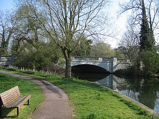
Fen Road Bridge or Fen Causeway Bridge is the third river Cam bridge overall and the first road bridge on its upstream in Cambridge. The road was formally opened on 9 December 1926.


