
The Bavarian Alps is a collective name for several mountain ranges of the Northern Limestone Alps within the German state of Bavaria.
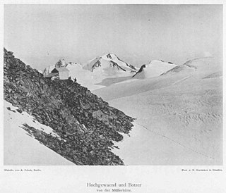
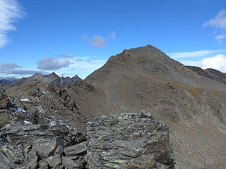
The Botzer is a mountain in the Stubai Alps in South Tyrol, Italy.

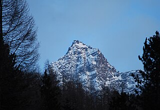
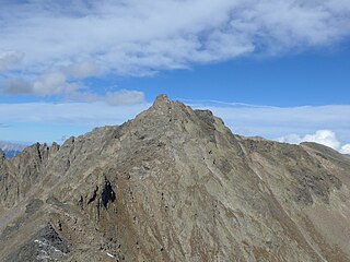
The Sonklarspitze, also Sonklarspitz, is a mountain in the Stubai Alps on the border between Tyrol, Austria, and South Tyrol, Italy.
The Alpine Club Guides were the standard series of alpine climbing guidebookss that cover all the important mountain groups in the Eastern Alps. They were produced jointly by the German (DAV), Austrian (ÖAV) and South Tyrol Alpine Clubs (AVS). They had been published since 1950 by the firm of Bergverlag Rother in Munich, Germany.

The Eastern Rhaetian Alps are a mountain range in the central part of the Alps.
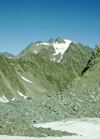
The Strahlkogel, at 3,288 m (AA), is the highest peak in the Larstiger Mountains, a subgroup of the Stubai Alps in the Austrian state of Tyrol. The Strahlkogel is also the highest mountain in the municipality of Umhausen. Its name comes from its great, white, light-reflecting, quartz layers, which allegedly cause the mountain to "radiate" (strahlen). It has the shape of a well-proportioned, steep and pointed pyramid. Ascending the Strahlkogel is difficult and it is thus only rarely visited, unlike the neighbouring 3,287-metre-high Breiter Grieskogel. The first ascent of the mountain was in 1833 by Peter Carl Thurwieser, but his route and the precise circumstances of the climb have not been passed on. On 28 August 1887 Ludwig Purtscheller and Fritz Drasch from Salzburg climbed the mountain. Their route led along the west arête. Today, this is the normal route and easiest way to reach the summit.

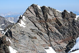
At 3,474 m (AA) the Ruderhofspitze is the fourth highest mountain in the Stubai Alps in Austria. It is part of the Alpein Mountains and lies in the Austrian state of Tyrol. As a result of its topographic isolation and good all-round views it is one of the most visited mountains in the Stubai. An almost two-kilometre-long arête, the Grawawand, runs away from the summit to the east. Less prominent ridges run south and northwestwards from the Ruderhofspitze. The peak was first ascended on 30 August 1864 by Karl Baedeker, Anton von Ruthner and mountain guides Pankraz Gleinser and Alois Tanzer.

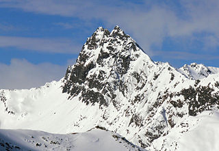
The Wilde Leck is a mountain, 3,361 m (AA), in the Stubai Alps in the Austrian state of Tyrol. It rises immediately west of the Sulztalferner glacier and towers above the Ötztal valley, 5.5 km northwest of Sölden. It has a rocky summit made of solid granite and prominent arêtes. In the Stubai Alps the Wilde Leck is one of the most difficult summits to climb, because its easiest route runs initially over glaciers and then up a rock face that is assessed as climbing grade III (UIAA).
The Hoher Seeblaskogel is a mountain, 3,235 m (AA), in the western part of the Stubai Alps in the Austrian state of Tyrol. Its independent summit lies between the cols of Winnebachjoch and Bachfallenscharte. To the south the Grüne-Tatzen glacier climbs to just below the summit. The Seeblaskogel has rock faces on all sides, below which lie the glaciers of Ochsenkarferner to the north and Seeblaskogelferner to the east.
The Gleirscher Fernerkogel, also Gleirschfernerkogl, formerly called the Roßkarspitze, is a mountain, 3,189 m (AA), in the Southern Sellrain Mountains, a subgroup of the Stubai Alps. It rises in the Austrian state of Tyrol. The old name, Roßkarspitze, was given to it during the military survey of the region in the 1850s. The first documented ascent was undertaken on 1 September 1883 by Ludwig Purtscheller and Hans Schöller, a "professor from Salzburg". Purtscheller gave the mountain its present name. A prominent 500-metre-long ridge runs eastwards from the unimposing summit.
The Hohe Villerspitze is a mountain, 3,087 m (AA), in the Southeastern Sellrain Mountains, a sub-group of the northern Stubai Alps in the Austrian state of Tyrol. The mountain has three tops that, together, form an isolated, massive and prominent rocky summit made of amphibolite. Due to its geographic dominance and easily accessibility the Villerspitze is a fairly frequently visited lookout mountain, but it is not one to be underestimated. The southwestern rock tower has a height of 3,087 m (AA), the middle one is 3,081 m (AA) and the northwestern top is 3,024 m (AA). A prominent arête runs south from the summit.

The Innsbrucker Hut is a mountain hut in the Stubai Alps at an altitude of 2,369 metres (7,772 ft) in the Gschnitz Valley, not far from the Pinnisjoch. It is managed by the Innsbruck Tourist Club section of the Austrian Alpine Club. The Innsbrucker Hütte is below the Habicht on the Stubai Hohenweg and is often visited.

The Innere Wetterspitze is a mountain, 3,053 metres high, in the Stubai Alps in the Austrian state of Tyrol. It lies between the Stubai and Gschnitztal valleys, rising to the north of and above the col of Simmingjöchl and is separated by the Lautererseejoch from the rather higher Äußere Wetterspitze (3,070 m). The two Wetterspitzen sit on the Habichtkamm, a mountain ridge that branches off the main chain of the Alps near the Feuerstein and heads northeastwards to the Elferspitze.

The Hochreichkopf is a mountain in the northwestern part of the Stubai Alps in the Austrian state of Tyrol. Its broad summit lies between the Niederreichjoch and Hochreichjoch cols east of and above the Ötztal valley.

The Schaufelspitze is a mountain, 3,332 m (AA), in the Stubai Alps in the Austrian state of Tyrol.
The Zwieselbacher Rosskogel is a double peak in the northern Stubai Alps in the Austrian state of Tyrol. Its summit offers a sweeping panorama to the north because no other higher mountains impede the view. To the south, by contrast, the view is restricted by higher summits in the Stubai Alps. The first well known ascent took place on 23 August 1881 by Ludwig Purtscheller accompanied by chamois hunter Franz Schnaiter from Zirl.
The Gleirscher Rosskogel is a mountain in the northern Stubai Alps in the Austrian state of Tyrol. It is not particularly independent, because about 750 metres to the north rises the higher summit of the Zwieselbacher Rosskogel (3,081 m). Formerly the 3,008 spot height on the arête between the two peaks was named as the Gleirscher Rosskogel, and this is still the case on many maps; in which case the present Gleirscher Rosskogel would then be called the Gleirscher Rosskopf. At the top is a small metal summit cross with a plaque inscribed with the present name of the peak and an elevation of 2,950 m.

The Rietzer Grießkogel is a mountain, 2,884 m (AA), and the highest peak in the Northern Sellrain Mountains, part of the Stubai Alps in the Austrian state of Tyrol. The summit is easily climbed on path no. 153. The first documented ascent was undertaken in 1829 by Innsbruck botanist, Andrä Sauter, a brother of Anton Sauter. As a result of its easy accessibility on well marked paths from Telfs in the Inn Valley and from the Sellrain Valley, it is a popular destination. Its name is derived from the village of Rietz at its northern foot in the district of Imst in the upper Inn valley.

The Kirchdach, also Kirchdachspitze, is a mountain, 2,840 m (AA), in the Stubai Alps in Tyrol, Austria.
