
Fifteenmile Creek is a 54-mile (87 km) long tributary of the Columbia River in the U.S. state of Oregon. It drains 373 square miles (966 km2) of Hood River and Wasco counties. Arising in the Cascade Range near Mount Hood, it flows northeast then west to its confluence with the Columbia near The Dalles.
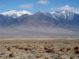
Deep Creek Valley is a 35-mile (56 km) long valley located in southwest Tooele County at the Utah-Nevada border; the extreme south of the valley is in northwest Juab County. The valley parallels the west flank of the Deep Creek Range, both north-trending. In the north-northeast, its outlet widens into the southwest of the Great Salt Lake Desert region.
Carrizo Creek, is a stream that arises in the mountains of San Diego County, California, and terminates in Carrizo Wash in Imperial County, a tributary in turn to San Felipe Creek that terminates in the Salton Sea.
Meeker Run is a tributary of Heberly Run in Sullivan County, Pennsylvania, in the United States. It is approximately 0.9 miles (1.4 km) long and flows through Davidson Township. Its watershed has an area of 0.41 square miles (1.1 km2). The stream has a low pH, although that could potentially be remedied. The main rock formations in the area are the Huntley Mountain Formation and the Burgoon Sandstone. The main soil associations in the vicinity of the stream are the Deep-Wellsboro-Oquaga association, the Wellsboro association, the Norwich association, and the Oquaga association.
Cross Run is a tributary of Catawissa Creek in Luzerne County, Pennsylvania, in the United States. It is approximately 1.1 miles (1.8 km) long and flows through Hazle Township. The stream is in the United States Geological Survey quadrangle of Conyngham. The stream has two reservoirs on it and has been used as a water supply for Hazleton since at least the late 1800s or early 1900s. Both of the stream's reservoirs have dams. The stream has one unnamed tributary. Cross Run and its unnamed tributary are considered by the Pennsylvania Department of Environmental Protection to be impaired for part of their lengths.

Laguña Creek also formerly also known as Tyende Creek, is a stream in the Navajo and Apache Counties of Arizona. Laguña Creek has its source at 36°41′15″N110°30′36″W, at the confluence of Long Canyon and Dowozhiebito Canyon at an elevation of 6325 feet / 1928 meters at the head of Tsegi Canyon. Its mouth is in the Chinle Valley at its confluence with Chinle Wash which together forms Chinle Creek, at an elevation of 4774 feet / 1455 meters. Chinle Creek is a tributary of San Juan River which is in turn a tributary of the Colorado River.

Chinle Creek is a tributary stream of the San Juan River in Apache County, Arizona and San Juan County, Utah. Its source is at 36°53′40″N109°44′37″W, the confluence of Laguña Creek with Chinle Wash where it forms Chinle Creek, 7 miles northeast of Dennehotso, Arizona at an elevation of 4,774 feet (1,455 m). Its mouth is at its confluence with the San Juan River at 37°11′53″N109°42′57″W at an elevation of 4,229 feet (1,289 m), 9 miles northeast of Mexican Hat, Utah.
Salt Creek is a stream in Juab County, Utah. Its mouth is at an elevation of 5,226 feet / 1,593 meters. Its source is located at 39°48′28″N111°43′43″W, the confluence of the Left Fork and Right Fork of Salt Creek in the Nebo Basin east of Mount Nebo.
Palm Canyon Wash is an arroyo and tributary ephemeral stream or wash of the Whitewater River, in Riverside County, California.
Indian Creek originally known as Sage Creek, is a tributary stream of the Beaver River in Beaver County, Utah. Its mouth is at its confluence with the Beaver River at an elevation of 5,499 feet / 1,676 meters above the Minersville Reservoir, 0.4 miles south of Adamsville. Its source is at 38°24′31″N112°26′55″W, on the northwest slope of Mount Baldy at an elevation of 10,600 feet in the Tushar Mountains.
Buck Creek is a stream in Lincoln County in the U.S. state of Missouri. It is a tributary of the North Fork of the Cuivre River.
Bull Creek is a stream tributary to Animas Creek within Hidalgo County, New Mexico. Bull Creek is located east of Animas Creek, flows westward down from its source at 31°39′54″N108°41′28″W, at an elevation of approximately 5720 feet / 1,743 meters in the Animas Mountains to the east of the valley. It flows northwest from the west slope of Gillespie Mountain, to its confluence with Animas Creek in the Animas Valley at an elevation of 4,869 feet / 1,484 meters.

Currant Creek is a stream in eastern Juab County and southern Utah County in northern Utah, United States.
Coal Creek is a stream in Iron County, Utah. Its mouth lay at an elevation of 5,545 feet (1,690 m) in Cedar Valley in 1979, but that location is now a farm field, and its new terminus is located a little further upstream, 4.3 miles (6.9 km) northwest of Cedar City, Utah. Its source is at the confluence of Crow Creek and Ashdown Lake Creek, in Coal Canyon, at the foot of Cedar Mountain at 37°37′49″N112°56′10″W at an elevation of 7,075 feet (2,156 m). Coal Creek passes through Cedar City on its way to Cedar Valley.
South Mountains are a range of mountains primarily in White Pine County, Nevada and partially to the east in Juab County, Utah. The range is sometimes refereed to as the Deep Creek Mountains, or the Ibenpah Mountains. The South Mountains are divided from the Kern Mountains to the south by Tippett Canyon on the west and Pleasant Valley to the east. They are divided from the Deep Creek Range to the east in Utah by Johnson Canyon, on the north, and by Water Canyon on the south. The range is bounded on the north by Spring Creek Flat and on the west by Antelope Valley.
Spring Creek formerly known as West Creek, and Round Valley Creek, is a stream, tributary to West Deep Creek in White Pine County, Nevada with its source in Juab County, Utah.
West Deep Creek also known as Round Valley Creek, Spring Creek and West Creek is a tributary stream with its head at the confluence of Spring Creek and an unnamed stream, in White Pine County, Nevada, and its mouth in Tooele County, Utah at its confluence with East Deep Creek that forms the head of Deep Creek.
Ferber Hills is a range of hills in Elko County, Nevada and Tooele County, Utah. The range is formed in three parallel ridges of hills trending northwest to southeast. Its highest summit is Utah Peak, in the center of the central ridge of the range, at an elevation of 6,680 feet / 2,036 meters, just east of the state line in Tooele County, Utah. Its second highest Summit is Ferber Peak, that rises to and elevation of 6,601 feet / 2,012 meters, at the south end of the southernmost ridge of the range at 40°12′43″N114°03′18″W just west of the state line in Elko County, Nevada. The highest point in the smaller northernmost ridge is an unnamed summit at 40°17′12″N113°59′48″W with an elevation of 5,745 feet / 1,751 meters in Tooele County.
Deep Creek is stream in Tooele County, Utah. Deep Creek, heads in Deep Creek Valley at an elevation of 5,282 feet /1,610 meters, at the confluence of West Deep Creek and East Deep Creek at 40°01′51″N113°59′40″W. From there it flows northeast to dissipate in the Great Salt Lake Desert at an elevation of 4,255 feet / 1,297 meters. At times of high water the stream may flow to Tank Wash 11 miles north northeast of Gold Hill.


