
Palmer Municipal Airport is a public airport located 1 mi (1.6 km) southeast of the central business district of Palmer, a city in Matanuska-Susitna Borough, Alaska, United States. This airport is owned by the City of Palmer.

Toledo Suburban Airport is a public use airport located two nautical miles (3.7 km) southwest of the central business district of Lambertville, a city in Monroe County, Michigan, United States. It is located just north of Michigan's border with Ohio and northwest of the city of Toledo, Ohio. It is included in the Federal Aviation Administration (FAA) National Plan of Integrated Airport Systems for 2017–2021, in which it is categorized as a general aviation facility.

Sky Ranch Airport, also known as Sky Ranch Estates or Aérodrome de Sky Ranch, is a privately owned, public use airport located two nautical miles (4 km) southwest of the central business district of Sandy Valley, a town in Clark County, Nevada, United States.

Phillips Flying Ranch Airport is a public airport located fifteen miles (24.1 km) southeast of the central business district (CBD) of Rockwall, in Rockwall County, Texas, United States. The airport itself is located in Hunt County

Fitiuta Airport is a public airport located in Fiti‘uta, a village on the island of Ta‘ū in American Samoa, an unincorporated territory of the United States. Fitiuta Airport replaced Tau Airport, which was officially deactivated after the construction and activation of Fitiuta Airport in 1990. The Fitiuta airport is owned by the Government of American Samoa.
Massey Ranch Airpark is a general aviation airport in Edgewater, Florida, United States. The airport is part of an airport community, with homes located on the airport, and hangars built next to most homes. The airport was opened in 1957 and is open to the public.
Big Muddy Ranch Airport is a private airport located 13 miles southeast of Antelope in Wasco County, Oregon, USA on the grounds of Big Muddy Ranch, known in the mid-1980s as the site of Rajneeshpuram. After being constructed by the members of the Rajneesh movement, the airport was known as the Rajneeshpuram Airport.
Whitehorse Ranch Airport is a private airport located on the Whitehorse Ranch, 18 miles northeast of Fields in Harney County, Oregon, USA.
Cottonwood Creek Ranch Airport is a private Airport located 2 miles east of Harper in Malheur County, Oregon, USA.
Tamarack Springs Ranch Airport is a private Airport located 2 miles northwest of Lostine in Wallowa County, Oregon, USA.
Heavens Gate Ranch Airport is a private airport located 4 miles west of Oakland in Douglas County, Oregon, USA.
Sage Ranch Airport is a private airport located 7 miles southeast of Sisters in Bend, in Deschutes County, Oregon, USA. It is privately owned and operated.
Lone Oaks Ranch Airport is a private airport located 2 miles southeast of Stayton in Linn County, Oregon, USA.

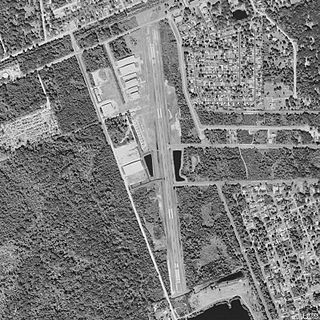
Mac Crenshaw Memorial Airport is a city-owned public-use airport located 2 nautical miles (4 km) northeast of the central business district of Greenville, a city in Butler County, Alabama, United States.
Varnell Heliport is a heliport located in unincorporated Galveston County, Texas, United States. The airport is located south of League City, east of Alvin, and northwest of Santa Fe.
Creasy Airport is an airport located in unincorporated Galveston County, Texas, United States. The airport is located southwest of Santa Fe and west of Hitchcock.

Jaffrey Airport–Silver Ranch is a public use airport in Cheshire County, New Hampshire, United States. It is owned by the Jaffrey Municipal Airport Development Corp. and is located one nautical mile (1.85 km) southeast of the central business district of Jaffrey, New Hampshire. It is included in the Federal Aviation Administration (FAA) National Plan of Integrated Airport Systems for 2017–2021, in which it is categorized as a general aviation facility.

Milwrick Flying "M" Airport is a privately owned, public use airport located three nautical miles (6 km) northeast of the central business district of Lincoln, a village in Alcona County, Michigan, United States. It was formerly known as Flying "M" Ranch Airport.

Reed Ranch Airport is a public use airport located 12 nautical miles southwest of the central business district of Yellow Pine, in Valley County, Idaho, United States. It is owned by the Idaho Division of Aeronautics / USFS.
Lazy G Bar Ranch Airport is a privately owned public airport in Decatur, Wise County, Texas, United States, located approximately 5 nautical miles (9.3 km) northeast of the central business district. The airport has no IATA or ICAO designation.
