Snillfjord is a municipality in Trøndelag county, Norway. It is part of the Fosen region. The administrative centre of the municipality is the village of Krokstadøra. Other villages in Snillfjord include Ytre Snillfjord, Hemnskjela, and Vutudal.

Botngård is the administrative centre of the municipality of Bjugn in Trøndelag county, Norway. The village is located at the end of the Bjugnfjorden. It is about 5 kilometres (3.1 mi) north of the village of Høybakken, about 12 kilometres (7.5 mi) east of the village of Nes, and about 9 kilometres (5.6 mi) south of village of Oksvoll.

Berkåk is the administrative centre of Rennebu Municipality in Trøndelag county, Norway. It is located in the Orkladalen valley along the river Orkla. The village lies about 10 kilometres (6.2 mi) north of the village of Ulsberg and 8 kilometres (5.0 mi) southeast of the village of Stamnan. The European route E06 highway runs through the village, as does the Dovrebanen railway line which stops at Berkåk Station. Berkåk Church is also located in the village.
Straumen is the administrative centre of the municipality of Inderøy in Trøndelag county, Norway. It is located along the Trondheimsfjord at the northeastern side of the Inderøya peninsula, next to the Børgin fjord. The village lies about 2 kilometres (1.2 mi) east of the village of Sakshaug and about 7 kilometres (4.3 mi) west of the villages of Røra and Hylla. The village has a slaughterhouse, a folk high school, and a museum. The Sakshaug Church and the historic Old Sakshaug Church lie just west of Straumen.
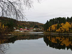
Forsnes is a village in the municipality of Hitra in Trøndelag county, Norway. It is located on the southwestern corner of the island of Hitra, along the Trondheimsleia. It is about 15 kilometres (9.3 mi) south of the village of Kvenvær and about 35 kilometres (22 mi) west of the village of Sandstad. The mountain Mørkdalstuva lies about 8 kilometres (5.0 mi) northeast of Forsnes. The population of the village is about 80.

Børsa is the administrative centre of the municipality of Skaun in Trøndelag county, Norway. The village lies along the shore of the Gaulosen, an arm off the vast Trondheimsfjorden. It is about 6 kilometres (3.7 mi) west of the village of Buvika, along the European route E39 highway. The villages of Skaun and Eggkleiva lie just a short distance to the south and the town of Orkanger lies about 15 kilometres (9.3 mi) to the west. Historically, this village was the administrative centre of the old municipality of Børsa from 1838 until 1965. [
Brekstad is the administrative centre of the municipality of Ørland in Trøndelag county, Norway. The town is located along the Trondheimsfjord at the entrance to the Stjørnfjorden. The town is located about 5 kilometres (3.1 mi) south of the village of Uthaug and about 7 kilometres (4.3 mi) west of the villages of Austrått and Ottersbo.
Hestvika is a village in the municipality of Hitra in Trøndelag county, Norway. The village is located on the southeastern tip of the island of Hitra along the Trondheimsleia, about 6 kilometres (3.7 mi) east of the village of Sandstad and the entrance to the Hitra Tunnel. The 0.36-square-kilometre (89-acre) village has a population (2018) of 263 and a population density of 731 inhabitants per square kilometre (1,890/sq mi).

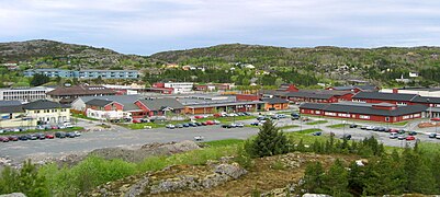
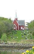
Sandstad is a village in Hitra municipality in Trøndelag county, Norway. The village is located along the Trondheimsleia on the southeastern coast of the island of Hitra, about 6 kilometres (3.7 mi) southwest of the village of Hestvika. The north entrance to the Hitra Tunnel lies just south of the village of Sandstad. The Terningen lighthouse lies in the Trondheimsleia, about 3 kilometres (1.9 mi) southwest of the village. In 2018, there were about 229 residents in the village. Sandstad Church is located here.
Hammarvika is a village in the municipality of Frøya in Trøndelag county, Norway. The village is located about 4 kilometres (2.5 mi) south of the municipal center of Sistranda on the southeastern side of the island of Frøya. The 0.58-square-kilometre (140-acre) village has a population (2018) of 461 and a population density of 795 inhabitants per square kilometre (2,060/sq mi).
Melandsjøen or Melandsjø is a village in the municipality of Hitra in Trøndelag county, Norway. The village is located on the north shore of the island of Hitra, just across the strait from the island of Dolmøya.
Ansnes is a village in the municipality of Hitra in Trøndelag county, Norway. The village is located along the Fillfjorden on the northeastern coast of the island of Hitra. There is a bridge from Ansnes to the island of Fjellværsøya to the east. The village is located about 6 kilometres (3.7 mi) north of the municipal center of Fillan. The village has a fishing harbor and is home to many aspects of the fishing industry.
Hitra is an island in Hitra municipality in Trøndelag county, Norway. The 571.5-square-kilometre (220.7 sq mi) island is the 7th largest island in Norway and it is the largest island south of the Lofoten archipelago. The island lies between the Trondheimsleia strait and the Frøyfjorden, just southwest of the entrance to the Trondheimsfjorden. Hitra is surrounded by many islands such as Smøla to the southwest; Bispøyan, Helgbustadøya, Dolmøya, and Frøya to the north; Ulvøya, Fjellværsøya, and Leksa to the east; and Hemnskjela and the mainland of Norway to the south. The 345-metre (1,132 ft) tall Mørkdalstuva is the highest point on the island.
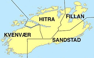
Sandstad is a former municipality in the old Sør-Trøndelag county, Norway. The 160-square-kilometre (62 sq mi) municipality existed from 1914 until its dissolution in 1964 when it was merged into what is now Hitra municipality in Trøndelag county. The former municipality of Sandstad included all of the southern and southeastern parts of the island of Hitra, plus the several islands in the Trondheimsleia off the shores of Hitra. The municipality had one church, Sandstad church, located in the village of Sandstad.
Kvenvær is a former municipality in the old Sør-Trøndelag county, Norway. The 216-square-kilometre (83 sq mi) municipality existed from 1913 until 1964. It is located in what is now the municipality of Hitra in Trøndelag county. The municipality included the western part of the island of Hitra plus many surrounding islands including Bispøyan. The administrative centre of the municipality was the village of Kvenvær where Kvenvær Church is located. Other villages in Kvenvær municipality included Forsnes and Andersskogan.

Mosvik is a village in Inderøy municipality in Trøndelag county, Norway. The village is located on the western shore of the Trondheimsfjorden, just south of the Skarnsundet strait and the Skarnsund Bridge. The island of Ytterøya lies offshore about 3 kilometres (1.9 mi) southeast of the village of Mosvik. Mosvik Church is located in the village. From 1901 until 2012, the village was the administrative centre of the old municipality of Mosvik.
Namsskogan is the administrative centre of Namsskogan municipality in Trøndelag county, Norway. The village is located in the Namdalen valley on an island in the middle of the river Namsen, although it also includes land on both sides of the river. The European route E06 highway and the Nordlandsbanen railway line both run through the village, with the train stopping at Namsskogan Station. The village of Brekkvasselv lies about 12 kilometres (7.5 mi) to the south. Bjørhusdal Church is located about 4 kilometres (2.5 mi) west of the village.