
Geodesy is the Earth science of accurately measuring and understanding Earth's geometric shape, orientation in space, and gravitational field. The field also incorporates studies of how these properties change over time and equivalent measurements for other planets. Geodynamical phenomena include crustal motion, tides and polar motion, which can be studied by designing global and national control networks, applying space and terrestrial techniques and relying on datums and coordinate systems.
Remote sensing is the acquisition of information about an object or phenomenon without making physical contact with the object, in contrast to in situ or on-site observation. The term is applied especially to acquiring information about the Earth and other planets. Remote sensing is used in numerous fields, including geography, land surveying and most Earth science disciplines ; it also has military, intelligence, commercial, economic, planning, and humanitarian applications, among others.

Geomatics is defined in the ISO/TC 211 series of standards as the "discipline concerned with the collection, distribution, storage, analysis, processing, presentation of geographic data or geographic information". Under another definition, it "consists of products, services and tools involved in the collection, integration and management of geographic data". It includes geomatics engineering and is related to geospatial science.

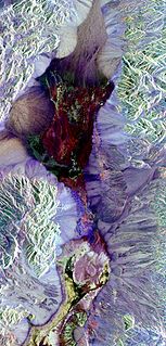
Satellite geodesy is geodesy by means of artificial satellites — the measurement of the form and dimensions of Earth, the location of objects on its surface and the figure of the Earth's gravity field by means of artificial satellite techniques. It belongs to the broader field of space geodesy. Traditional astronomical geodesy is not commonly considered a part of satellite geodesy, although there is considerable overlap between the techniques.
Geoinformatics is the science and the technology which develops and uses information science infrastructure to address the problems of geography, cartography, geosciences and related branches of science and engineering.

A geodetic control network is a network, often of triangles, which are measured precisely by techniques of terrestrial surveying or by satellite geodesy.
The American Society for Photogrammetry and Remote Sensing (ASPRS) is an American learned society devoted to photogrammetry and remote sensing. It is the United States' member organization of the International Society for Photogrammetry and Remote Sensing. Founded in 1934 as American Society of Photogrammetry and renamed in 1985, the ASPRS is a scientific association serving over 7,000 professional members around the world. As a professional body with oversight of specialists in the arts of imagery exploitation and photographic cartography. Its official journal is Photogrammetric Engineering & Remote Sensing (PE&RS), known as Photogrammetric Engineering between 1937 and 1975.

The Faculty of Geodesy at the University of Zagreb is the only Croatian institution providing high education in Geomatics engineering and the largest faculty in this domain in southeastern Europe.

The UNSW School of Surveying and Geospatial Engineering (SAGE), part of the UNSW Faculty of Engineering, was founded in 1970 and disestablished in 2013.
The International Society for Photogrammetry and Remote Sensing (ISPRS) is an international non-governmental organization that enhances international cooperation between the worldwide organizations with interests in the photogrammetry, remote sensing and spatial information sciences. Originally named International Society for Photogrammetry (ISP), it was established in 1910, and is the oldest international umbrella organization in its field, which may be summarized as addressing “information from imagery”.
Prof. em. Dr. Armin Gruen is, since 1984, professor and head of the Chair of photogrammetry at the Institute of Geodesy and Photogrammetry (IGP), Federal Institute of Technology (ETH) Zurich, Switzerland. Since 1 August 2009, he is retired and is now with the Chair of Information Architecture, ETH Zurich Faculty of Architecture. He is currently acting as a principal investigator on the Simulation Platform of the SEC-FCL in Singapore.
The Faculty of Geodesy and Land Management is one of the sixteen faculties of University of Warmia and Mazury in Olsztyn and prepares students to work in the following fields: digital photogrammetry and Internet photogrammetry, close range photogrammetry, engineering geodesy, satellite geodesy, higher geodesy, geomatics and spatial information systems, land management, numerical cartography, cadastral survey and common appraisal, mathematics and mathematical statistics, spatial and archeological reconstruction, positioning and navigation systems, remote sensing and photointerpretation, theory of deterministic chaos in dynamic analyses, theory of environment and real estate evaluation. Students of land management are prepared to work in local governments in the fields of real estate management and turnover, spatial planning, property counselling and expertise. Research on application of global satellite navigation systems, improving methods of acquiring, gathering and processing geodetic and satellite data and their use in special information systems as well as optimizing methods of space management are only a few examples of scientific fields of interest of the faculty employees.

The International Geodetic Student Organisation is an international, independent, non-political, non-profit organisation run by and for geodesy students and young geodesists.

The Institute of Geomatics (IG) was a public consortium made up of the Autonomous Government of Catalonia and the Polytechnic University of Catalonia, created by Decree Law 256/1997 of the Autonomous Government of Catalonia, on September 30, 1997. It was a founding member of the Associació Catalana d'Entitats de Recerca (ACER).
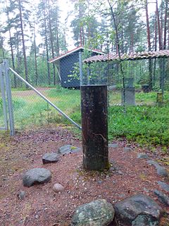
Nummela Standard Baseline is a baseline used to calibrate rangefinders, in Finland, located in the municipality of Vihti, Nummelanharju (esker) where it was built in 1932.
Geographic data and information is defined in the ISO/TC 211 series of standards as data and information having an implicit or explicit association with a location relative to Earth.
Sisi Zlatanova is a Bulgarian/Dutch researcher in geospatial data, geographic information systems, and 3D modeling. She works as a professor in the faculty of the Built Environment, at the University of New South Wales (UNSW), and is president of Technical Commission IV (Spatial Information Science) of the International Society for Photogrammetry and Remote Sensing.
The Journal of Spatial Science is an academic journal about spatial sciences published by Taylor & Francis on behalf of the Mapping Sciences Institute (Australia) and the Surveying and Spatial Sciences Institute. It covers cartography, geodesy, geographic information science, hydrography, digital image analysis and photogrammetry, remote sensing, surveying and related areas. Its editor-in-chief is Graeme Wright; its 2018 impact factor is 1.711.
The TUM Department of Civil, Geo and Environmental Engineering is a department of the Technical University of Munich, located at its Munich campus. Its main areas of research are civil engineering, environmental engineering and the earth sciences.

The TUM Department of Aerospace and Geodesy is a department of the Technical University of Munich, located in Ottobrunn. It combines the field of aerospace engineering with research in satellite navigation, earth observation and the basic geodetic disciplines.