
Oulunkylä is a suburb and a neighbourhood of Helsinki, the capital of Finland. It is located 6 kilometres (4 mi) north from the center of the city.

Kamppi is a neighbourhood in the centre of Helsinki, the capital of Finland. The name originally referred to a small area known as the "Kamppi field", but according to the current official designation, "Kamppi" encompasses a much larger area with a population of 10,000 in 2004.
Helsinki Railway Square is an open square immediately to the east of the Helsinki Central railway station in central Helsinki in Finland. The square serves as Helsinki's secondary bus station along with the main Kamppi Center bus station. The north side features the Finnish National Theatre, and the south side is formed of the Ateneum classical art museum. To the west side are the two ornate entrances to Helsinki Central station—a bigger one for public use, and a smaller one exclusively for the President of Finland and their official guests. The square is served by the Helsinki Metro system with Rautatientori metro station entrances at the south-west corner, and University of Helsinki metro station to the east.
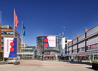
Messukeskus Helsinki, Expo and Convention Centre is the biggest and best-known convention center in Finland. It is located in the capital city of Helsinki, in the district of Pasila, a short walk northwards from the Pasila railway station.

Erottaja, Swedish: Skillnaden; Swedish:[ˈʃil.naːden]; lit. 'the difference'), is a public square near the centre of Helsinki, Finland.

Santahamina is an island and neighbourhood of Eastern Helsinki, Finland. At present it is a military base housing the Guard Jaeger Regiment, making access restricted. The Finnish National Defence University (NDU) is also located on the island.

Urheilupuisto (Finnish) or Idrottsparken (Swedish) is an underground metro station in Espoo on the Länsimetro extension of Helsinki metro. The station is located in western Tapiola, at the northern edge of Jousenpuisto Park and south of the Tapiolan Urheilupuisto. A 790-space car park was built next to the metro station and offers elevator access to the station.

Masala railway station is a station on the Helsinki commuter rail network located in the Masala district of Kirkkonummi, Finland, between the Kauklahti and Jorvas stations. The station is served by Helsinki commuter rail lines Y, U and L. Westbound trains towards Kirkkonummi and Siuntio use track one, while eastbound trains to Helsinki use track two.

Jorvas railway station is a railway halt on the Helsinki commuter rail network located in the town of Kirkkonummi, Finland, between the Masala and Tolsa stations. The station is served by Helsinki commuter rail L and U trains. The train station has two staggered platforms. Westbound trains to Kirkkonummi use track one, while eastbound trains to Helsinki use track two.

Luoma (Finnish) or Bobäck (Swedish) was a station on the VR commuter rail network located in Kirkkonummi, Finland, between the stations of Mankki and Masala. The station had two tracks, with track one serving trains towards Kirkkonummi and track two towards Helsinki. The station was opened in 1932, then named as Nokka. In that time, there was another station named Luoma, located about a kilometer more towards Helsinki. The station was out of use between 1944 and 1956, as the Porkkala Cape served as a Soviet military base and the frontier passed through the station. When the original Luoma station was shut down in 1978, the Nokka station was renamed as Luoma. Because of very low number of passengers, the station was closed a day after neighbouring station Mankki on 27 March 2016.

Käpylä is a neighbourhood of Helsinki with 7,600 inhabitants. Administratively speaking, Käpylä is a part of the Vanhakaupunki district.

Kaartinkaupunki is a neighbourhood in the southern part of Helsinki, Finland.

The Krepost Sveaborg was an Imperial Russian system of land and coastal fortifications constructed around Helsinki during the First World War. The purpose of the fortress was to provide a secure naval base for the Russian Baltic fleet and to protect Helsinki and block routes to Saint Petersburg from a possible German invasion. Krepost Sveaborg was part of Peter the Great's Naval Fortress, a coastal fortification system protecting access to Saint Petersburg by sea. The central part of Krepost Sveaborg was the old fortress of Suomenlinna where the fortress headquarters were located. Due to technological advances in artillery the old fortress was no longer capable of providing a sufficient protection, and a new main defensive line was built well beyond the old fortress boundaries. New coastal artillery guns built on outlying islands protected Krepost Sveaborg from the sea, while fortified lines constructed around Helsinki were intended to stop any attacks on land. The primary coastal guns were 10 in (254 mm) model 1891 guns and 6 in (152 mm) model 1892 Canet guns. Older 11 in (279 mm) model 1877 guns were also used. In summer 1917 the fortress had two hundred coastal or anti-landing guns, of which 24 were 10-inch guns in six batteries, 16 were 6-inch Canet guns in four batteries and twelve were 11-inch guns in three batteries. The artillery used in land fortifications included older coastal guns, old fixed carriage guns and newer light field guns. In March 1917, Krepost Sveaborg had a total of 463 guns, although many of them were obsolescent. Krepost Sveaborg was still partly incomplete in 1917 when the February Revolution halted most of the construction work. Some further construction work was carried out during the remaining year, but all work halted during the October Revolution. Following the Finnish Declaration of Independence, parts of the land fortifications were used in the Finnish Civil War. The coastal fortifications were later taken over by Finland to protect Helsinki, while the land fortifications were mostly abandoned and disarmed.
Hernesaari is a quarter in Helsinki, Finland.

Torkkelinmäki (Finnish), Torkelsbacken (Swedish) is a central neighborhood of Kallio, Helsinki, Finland. Its boundaries are Hämeentie on the east, Helsinginkatu on the north, Kaarlenkatu on the west and Viides linja on the south. Like elsewhere in Kallio, the area's apartments are small, for the most part consisting of one or two rooms.

Koivusaari metro station is a station located underwater on the Länsimetro extension of the Helsinki Metro.

Soukka (Finnish) or Sökö (Swedish) is an underground station on the western metro extension (Länsimetro) of the Helsinki Metro in Finland. The station is opened on 3 December 2022, located 1.3 kilometres southeast from Espoonlahti metro station and 1.6 kilometres west from Kaitaa metro station. The station has two exits, one on Soukantori and one on Yläkartanontie. Soukka is the southernmost metro station in Helsinki.

Nukari is a village located in the northeast part of Nurmijärvi municipality of Finland, near the border of Tuusula municipality. The nearest neighboring village is Jokela, about 4 kilometers. Next to Nukari is the national road 45, which runs between Helsinki, Tuusula and Hyvinkää. The population of village is about 350 inhabitants.

Tallinnanaukio is a square in the Itäkeskus quarter in Helsinki, Finland. There is direct access from the Tallinnanaukio to the Itis shopping center, and there is also one of the eastern entrances to the Itäkeskus metro station, from where the Helsinki Metro leaves the metro to the city's downtown center.

Lonna is a small island off Helsinki, opposite the Suomenlinna Passenger terminal. The island belongs to the Suomenlinna district. Lonna is about 150 meters long and the distance to the mainland is about 1.5 kilometers.

