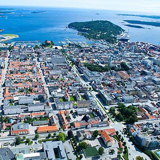
Kristiansand Region is a statistical metropolitan region in the counties of Vest-Agder and Aust-Agder in southern Norway. It is centered on the city of Kristiansand. The region consist of 6 municipalities in the centre of Southern Norway. Vennesla, Songdalen, and Birkenes are inland municipalities while Kristiansand, Søgne, and Lillesand are coastal municipalities. Kristiansand is the largest municipality in population in the region and Birkeland is the largest in area.

Vågsbygd is a borough and district in the city of Kristiansand in Vest-Agder county, Norway. It is the largest borough and district in Kristiansand. Until 1965, Vågsbygd was a part of Oddernes municipality. The borough includes the districts of Flekkerøy, Voiebyen, Vågsbygd/Augland, and Slettheia. The Kristiansand Cannon Museum on Kroodden is an authentic fortress from World War II.

Tinnheia is a district in the city of Kristiansand in Vest-Agder county, Norway. The population is around 3,660 (2014). It is part of the borough of Grim, and it is generally populated with mostly apartment homes, with a high percentage of immigrants. West of Tinnheia is the district of Hellemyr, to the east is the district of Grim (centrum), and to the south is the district of Slettheia.

Slettheia is a district in the borough Vågsbygd in the city of Kristiansand in Vest-Agder county, Norway. The population was about 4,000 in 2014. It is the most populated immigrant settlement in Kristiansand. The district was the childhood home for Crown Princess Mette-Marit of Norway. Public transportation is available with local city buses every day. Slettheia has one elementary and one junior high, the closest high school is "Vågsbygd High School".

Kjerrheia is a neighbourhood in the city of Kristiansand in Vest-Agder county, Norway. It is located in the borough of Vågsbygd and in the district of Vågsbygd. The neighborhood is located west of Fiskåtangen, north of Augland, and east of Hasselbakken.

Nordtjønnåsen is a neighbourhood in the city of Kristiansand in Vest-Agder county, Norway. It is located in the borough of Vågsbygd and in the district of Vågsbygd. The neighborhood is located in the northwestern corner of the district, south of Slettheia and west of Hasselbakken.

Kartheia is a neighbourhood in the city of Kristiansand in Vest-Agder county, Norway. It is located in the northern part of the borough of Vågsbygd and in the district of Slettheia. The neighborhood lies southwest of the junction of the European route E39 highway and the County Road 456. The district of Hellemyr lies to the north. Kartheia contains residential areas as well as a large industrial area. Gislemyr lies to the south, Trane lies to the west, and Hannevika lies to the east.

Auglandslia is a neighbourhood in the city of Kristiansand in Vest-Agder county, Norway. The neighborhood is located in the borough of Vågsbygd and in the district of Vågsbygd. It is located north of Augland, west of Skyllingsheia, and south of Granlia and Fiskåtangen.

Blørstad is a neighbourhood in the city of Kristiansand in Vest-Agder county, Norway. It is located in the borough of Vågsbygd and in the district of Slettheia. Blørstad has residential and industrial areas. It lies north and west of Fiskåtangen, southeast of Kartheia, and south of Hannevika.

Skyllingsheia is a neighbourhood in the city of Kristiansand in Vest-Agder county, Norway. It is located in the borough of Vågsbygd and in the district of Vågsbygd. Skyllingsheia is north of the neighborhood of Auglandsbukta, south of Lumber, and east of central Vågsbygd.

Granlia is a neighbourhood in the city of Kristiansand in Vest-Agder county, Norway. The neighborhood is located in the borough of Vågsbygd and in the district of Vågsbygd. Granlia is north of Vågsbygd sentrum, south of Karuss, west of Kjerrheia, and east of Nordtjønnåsen.

Karuss is a neighbourhood in the city of Kristiansand in Vest-Agder county, Norway. It is located in the borough of Vågsbygd and in the district of Slettheia. Karuss is northwest of Kjerrheia, southwest of Gislemyr, west of Trekanten, and east of Nordtjønnåsen.

Gislemyr is a neighbourhood in the city of Kristiansand in Vest-Agder county, Norway. It is located in the borough of Vågsbygd and in the district of Slettheia. Gislemyr is north of Karuss, and south of Trane, and west of Blørstad and Fiskåtangen.

Trane or Rugde is a neighbourhood in the city of Kristiansand in Vest-Agder county, Norway. It is located in the northern part of the borough of Vågsbygd and in the district of Slettheia. Trane/Rugde is northwest of Gislemyr, north of Nedre Slettheia, south of Rige, and east of Øvre Slettheia.

Nedre Slettheia is a neighbourhood in the city of Kristiansand in Vest-Agder county, Norway. It is located in the borough of Vågsbygd and in the district of Slettheia. Nedre Slettheia is south of Rugde, northeast of Gislemyr, west of Blørstad, and east of Øvre Slettheia.

Slettheitoppen or Øvre Slettheia is a neighbourhood in the city of Kristiansand in Vest-Agder county, Norway. It is located in the borough of Vågsbygd and in the district of Slettheia. The neighborhood lies west of Trane and northwest of Nedre Slettheia. The Øvre Slettheia skole is an elementary school in the neighbourhood.

Lumber is a neighbourhood in the city of Kristiansand in Vest-Agder county, Norway. It is located in the borough of Vågsbygd and in the district of Vågsbygd. Lumber is a large industrial area. It is north of Skyllingsheia, south of Trekanten, and east of Kjerrheia.

Oddernes is a former municipality in Vest-Agder county, Norway. The 103-square-kilometre (40 sq mi) municipality existed from 1838 until its dissolution in 1964. The administrative centre was the village of Lund on the east side of the river Otra near where Lund Church is located. The former area of the municipality makes up the western part of the municipality of Kristiansand. It encircled the town of Kristiansand, and it included the villages such as Flekkerøy, Vågsbygd, Slettheia, Lund, Strai, Mosby, and Justvik. Today, the town of Kristiansand has a borough named Oddernes, but it has very different boundaries than the old municipality had.


