
The New Territories is one of the three main regions of Hong Kong, alongside Hong Kong Island and the Kowloon Peninsula. It makes up 86.2% of Hong Kong's territory, and contains around half of the population of Hong Kong. Historically, it is the region described in the Convention for the Extension of Hong Kong Territory. According to that treaty, the territories comprise the mainland area north of Boundary Street on the Kowloon Peninsula and south of the Sham Chun River, as well as over 200 outlying islands, including Lantau Island, Lamma Island, Cheung Chau, and Peng Chau in the territory of Hong Kong.

The Kowloon–Canton Railway was a railway network in Hong Kong. It was owned and operated by the Kowloon–Canton Railway Corporation (KCRC) until 2007. Rapid transit services, a light rail system, feeder bus routes within Hong Kong, and intercity passenger and freight train services to China on the KCR network, have been operated by the MTR Corporation since 2007.

Tai Po District is one of the 18 districts of Hong Kong. The suburban district covers the areas of Tai Po New Town, Tai Po Tau, Tai Po Kau, Hong Lok Yuen, Ting Kok, Plover Cove, Lam Tsuen Valley, Tai Mei Tuk and other surrounding areas, and its exclaves Sai Kung North, in the northern part of the Sai Kung Peninsula and including islands such as Grass Island, and Ping Chau. Tai Po proper and Sai Kung North are divided by the Tolo Channel and the Tolo Harbour. The district is located in the Eastern New Territories. The de facto administrative centre of the district is Tai Po New Town.
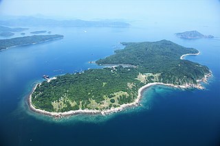
Grass Island or Tap Mun is an island in Hong Kong, located in the northeastern part of the territory. Its area is 1.69 km2 (0.65 sq mi). Administratively, it is part of the Tai Po District. There are about 100 people living on the island, and feral cattle are known on the island.

The Battle of Hong Kong, also known as the Defence of Hong Kong and the Fall of Hong Kong, was one of the first battles of the Pacific War in World War II. On the same morning as the attack on Pearl Harbor, forces of the Empire of Japan attacked the British Crown colony of Hong Kong around the same time that Japan declared war on Great Britain. The Hong Kong garrison consisted of British, Indian and Canadian units, also the Auxiliary Defence Units and Hong Kong Volunteer Defence Corps (HKVDC).

Tai Wai is an area in the New Territories, Hong Kong, located between Sha Tin and the Lion Rock, within the Sha Tin District.

Sha Tin, also spelt Shatin, is a neighbourhood along Shing Mun River in the eastern New Territories, Hong Kong. Administratively, it is part of the Sha Tin District. Sha Tin is one of the neighbourhoods of the Sha Tin New Town project.
Kam Tin, or Kam Tin Heung, is an area in the New Territories, Hong Kong. It lies on a flat alluvial plain north of Tai Mo Shan mountain and east of Yuen Long town. It was formerly known as Sham Tin (岑田). Administratively, it is part of Yuen Long District.

Yuen Long is a town in the western New Territories, Hong Kong. To its west lie Hung Shui Kiu (洪水橋), Tin Shui Wai, Lau Fau Shan and Ha Tsuen, to the south Shap Pat Heung and Tai Tong, to the east Au Tau and Kam Tin (錦田), and to the north Nam Sang Wai.

Tai Po is an area in the New Territories of Hong Kong. It refers to the vicinity of the traditional market towns in the area presently known as Tai Po Old Market or Tai Po Kau Hui (大埔舊墟) on the north of Lam Tsuen River and the Tai Po Hui on Fu Shin Street on the south of the Lam Tsuen River, near the old Tai Po Market railway station of the Kowloon-Canton Railway. Both market towns became part of the Tai Po New Town in the late 1970s and early 1980s. In present-day usage, "Tai Po" may refer to the area around the original market towns, the Tai Po New Town, or the entire Tai Po District.
Tai Po New Town, or Tai Po Town, is a new town and non-administrative area in Tai Po District, in the New Territories, Hong Kong. The area is a planned town that surrounding the existing indigenous market towns Tai Po Hui and Tai Po Kau Hui, as well as east of the existing indigenous villages that located on the Lam Tsuen Valley as well as west of those villages in Ting Kok and Tai Mei Tuk and south of those villages in Nam Hang, Fung Yuen and Sha Lo Tung. Most of the lands of the new town were obtained by land reclamation. In present day, Tai Po New Town was simply known as Tai Po. The new town are largely covered by the government Tai Po Outline Zoning Plan, which legally regulated the land use of the area, on top of the terms in the land lease contract with the government. Some of the land lease within the area, were known as Tai Po Town Lot № foo. In election, the town had a different zoning scheme for the election constituencies.

The Old District Office North, or the Law Ting Pong Scout Centre, is a building located at 20 Wan Tau Kok Lane, Tai Po in the New Territories of Hong Kong, near the Old Tai Po Police Station.

Anderson Road is a road on the eastern border of the New Territories and New Kowloon in Hong Kong. It starts near the junction of Clear Water Bay Road and New Clear Water Bay Road, above Shun Lee Estate, then continues southeast to Tseng Lan Shue (井欄樹) and eastward through the hills above Sau Mau Ping, and finally ends at Po Lam Road (寶琳路) in Ma Yau Tong.
Tai Po Market or Tai Po Hui is the name of an area within the modern-day Tai Po New Town in the Tai Po District, in the New Territories, Hong Kong. However, its exact location changed from time to time. It is considered as the town centre of the area known as Tai Po. The area was first established as a market town, at the location of the modern-day residential and commercial area Tai Po Old Market, or Tai Po Kau Hui (大埔舊墟), which is near the present-day area Tai Wo. Later on, a new market, Tai Wo Shi (太和市) was established across the river and when the Kowloon-Canton Railway British Section was opened in 1910, it was the site of a flag station named Tai Po Market. However, all three areas do not overlap, and are divided by Lam Tsuen River or Tai Po Tai Wo Road. Tai Po Market, Tai Po Old Market and Tai Wo Estate are all within modern day Tai Po New Town.

The Old Tai O Police Station is a former police station in Hong Kong. It is located on the small hill next to Tai O Ferry Pier, at the south-western tip of Tai O, which can be considered the most westerly point within Hong Kong.

Tai Po Lookout is a historical residential building situated at No. 11, Lookout Link, Tai Po Kau, Tai Po District, in the New Territories of Hong Kong.

The Old Tai Po Police Station is a former Hong Kong police station at the top of Tai Po Wan Tau Tong Hill. It is located at No. 11 Wan Tau Kok Lane, Tai Po, New Territories, Hong Kong, near the Old District Office North.

Ting Kok is an area and a village in New Territories, the northeastern part of Hong Kong. It is located on the northern shore of Plover Cove and west of Tai Mei Tuk. Administratively, it is part of Tai Po District.

The Six-Day War was a brief war fought between the British Empire and several punti clans of the New Territories in Hong Kong from 14–19 April 1899. Several punti clan leaders were opposed to the British takeover of the New Territories, which had been approved by the Qing dynasty via the Second Convention of Peking. Fearing the loss of their traditional land rights, a force of 2,600 militiamen attacked nearby British forces before being quickly beaten back, suffering 500 dead in the process. Governor Henry Arthur Blake took a conciliatory stance towards the punti clans, agreeing to acknowledge their land rights, which continue to be recognised into the present day.

