
The City of Warrnambool is a local government area in the Barwon South West region of Victoria, Australia, located in the south-western part of the state. It covers an area of 121 square kilometres (47 sq mi) and in June 2018 had a population of 34,862. It is entirely surrounded by the Shire of Moyne and the Southern Ocean. It is one of only a few regional councils in Victoria to remain serving just one urban district after the amalgamation process of 1994, although through that process it did gained some portions of the former Shire of Warrnambool.
Warrnambool is a city on the south-western coast of Victoria, Australia. At the 2021 census, Warrnambool had a population of 35,743. Situated on the Princes Highway, Warrnambool (Allansford) marks the western end of the Great Ocean Road and the southern end of the Hopkins Highway.
The Mahogany Ship is a putative early Australian shipwreck that is believed by some to lie beneath the sand in the Armstrong Bay area, approximately 3 to 6 kilometres west of Warrnambool in southwest Victoria, Australia. In many modern accounts it is described as a Spanish or Portuguese caravel after the wreck was associated with the theory of Portuguese discovery of Australia by Kenneth McIntyre in his 1977 book The Secret Discovery of Australia. The most recent research has questioned this theory and provided other explanations.

The Shipwreck Coast of Victoria, Australia stretches from Cape Otway to Port Fairy, a distance of approximately 130 km. This coastline is accessible via the Great Ocean Road, and is home to the limestone formations called The Twelve Apostles.

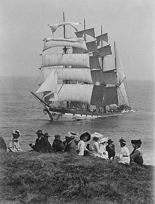
Loch Ard was an iron-hulled clipper ship that was built in Scotland in 1873 and wrecked on the Shipwreck Coast of Victoria, Australia in 1878.
The Falls of Halladale was a four-masted iron-hulled barque that was built in 1886 for the long-distance bulk carrier trade. Her dimensions were 83.87m x 12.64m x 7.23m and she displaced 2,085 GRT and 2,026 NRT. Built for the Falls Line at the shipyard of Russell & Co., Greenock on the River Clyde, she was named after a waterfall on the Halladale River in the Caithness district of Scotland. The ship's design was advanced for her time, incorporating features that improved crew safety and efficiency such as elevated bridges to allow the crew to move between forward and aft in relative safety during heavy seas.

Bay of Islands Coastal Park is a 32 kilometres long coastal reserve located in Victoria, Australia on the Great Ocean Road between Peterborough and Warrnambool. Lookout areas with parking are provided at the Bay of Martyrs, the Bay of Islands, Three Mile Beach and Childers Cove.

Fort Canning Lighthouse also known as Fort Canning Light is located on top of Fort Canning Hill and was formerly one of the 13 important lighthouses in the Straits of Malacca. Located nearby with The Flagstaff and the Time Ball, the three navigation structures played an essential role during the early maritime history of Singapore.

The Shire of Belfast was a local government area about 290 kilometres (180 mi) west-southwest of Melbourne, the state capital of Victoria, Australia. The shire covered an area of 5,190 square kilometres (2,003.9 sq mi), and existed from 1853 until 1994.

The Shire of Mortlake was a local government area about 220 kilometres (137 mi) west of Melbourne, the state capital of Victoria, Australia. The shire covered an area of 2,137 square kilometres (825.1 sq mi), and existed from 1860 until 1994.

The Shire of Warrnambool was a local government area located about 260 kilometres (162 mi) west-southwest of Melbourne, the state capital of Victoria, Australia. The shire covered an area of 1,605 square kilometres (619.7 sq mi), and existed from 1854 until 1994.

The Borough of Port Fairy was a local government area about 290 kilometres (180 mi) west-southwest of Melbourne, the state capital of Victoria, Australia. The borough covered an area of 22.72 square kilometres (8.8 sq mi), and existed from 1856 until 1994. Its area was surrounded by the Shire of Belfast and the Southern Ocean.
The Sisters is a settlement in Victoria, Australia. It is located about 38 km north east of Warrnambool and about 17 km northwest of Terang.
Emmanuel College is a Catholic, co-educational, secondary college in Warrnambool, Victoria, Australia. The college is situated on three campuses in Warrnambool, located at the end of the Great Ocean Road in Victoria's Western District. The college is co-sponsored by the Sisters of Mercy who established St Ann's College in 1872 and the Congregation of Christian Brothers who founded St Joseph's Christian Brothers' College in 1902. Emmanuel College was the result of an amalgamation of the two colleges in 1991.

The Port Fairy - Warrnambool Rail Trail is a 37 kilometre rail trail in southwestern Victoria, Australia. The official opening of the trail took place on 31 May 2012 at the Koroit Railway station building.

The Port Fairy to Warrnambool Important Bird Area comprises a 14 km2 strip of coastal land lying between the town of Port Fairy to the west and the regional city of Warrnambool to the east, in south-western Victoria, Australia.

Warrnambool College is a government high school in the regional town of Warrnambool in south-west Victoria, Australia.

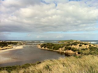
Middle Island is a small, rocky island lying close to the shore of south-western Victoria, Australia, in Stingray Bay next to the city of Warrnambool. It is a wildlife sanctuary that is home to breeding colonies of little penguins and short-tailed shearwaters. It is closed to general public access because of the low penguin population.
The Electoral district of Belfast and Warrnambool was one of the original sixteen electoral districts of the unicameral Legislative Council of the British colony of Victoria in 1851 to 1856.
The Cheese World Museum is part of the Allansford Cheese World Tourist complex, located in Allansford, Victoria. The museum contains objects and exhibits related to the farming industry and the history of Australia's dairy industry, including cheese and butter making implements.

