Wisdom is a census-designated place (CDP) in Beaverhead County, Montana, United States. The population was 98 at the 2010 census. The ZIP Code of the area is 59761. The town includes three tourist lodgings, service station, grocery, school (K-8), post office and a Forest Service office.

Sun River is a census-designated place (CDP) in Cascade County, Montana, United States. The population was 124 at the 2010 census. It is part of the Great Falls, Montana Metropolitan Statistical Area.

Tahoe City is an unincorporated town in Placer County, California. Tahoe City is located on the shore of Lake Tahoe, at the outlet of the Truckee River.

Pioche is an unincorporated town in Lincoln County, Nevada, United States, approximately 180 miles (290 km) northeast of Las Vegas. U.S. Route 93 is the main route to Pioche and bypasses the town center just to the east, with Nevada State Route 321 and Nevada State Route 322 providing direct access. Pioche is the county seat of Lincoln County. Pioche is named after François Louis Alfred Pioche, a San Francisco financier and land speculator originally from France. The town's population was 1,002 at the 2010 census.

The climate of Chicago is classified as hot-summer humid continental with hot humid summers and cold, occasionally snowy winters. All four seasons are distinctly represented: Winters are cold and often see snow with below 0 Celsius temperatures and windchills, while summers are warm and humid with temperatures being hotter inland, spring and fall bring bouts of both cool and warm weather and fairly sunny skies. Annual precipitation in Chicago is moderate and relatively evenly distributed, the driest months being January and February and the wettest July and August. Chicago's weather is influenced during all four seasons by the nearby presence of Lake Michigan.

Embarrass is an unincorporated community in Embarrass Township, Saint Louis County, Minnesota, United States.
The climate of Salt Lake City, Utah features cold and snowy winters, hot and dry summers, and modest to light seasonal rainfall. Lying in the Salt Lake Valley, the city is surrounded by mountains and the Great Salt Lake. Under the Köppen climate classification, Salt Lake City has either a Mediterranean climate (Csa) or dry-summer continental climate (Dsa) depending on which variant of the system is used, though it borders on a cold semi-arid climate (BSk) due to the city's relatively low precipitation.

Chemult is an unincorporated community and census-designated place in Klamath County, Oregon, United States, on U.S. Route 97 near the drainage divide between the Klamath and Columbia Rivers. Chemult has a population of about 80 people. Chemult's elevation is 4,764 feet (1,452 m).
The climate of San Diego, California, is classified as a hot-summer Mediterranean climate. The basic climate features hot, sunny, and dry summers, and cooler, wetter winters. However, San Diego is much more arid than typical Mediterranean climates, and winters are still dry compared with most other zones with this type of climate. The climate at San Diego International Airport, the location for official weather reports for San Diego, as well as the climate at most beach areas, straddles the border between BSh and BSk due to the mild winters and cool summers in these locations.
The climate of Houston is classified as a humid subtropical climate, with tropical influences. August normally ranks as the warmest month at an average temperature of 95 °F (35 °C) and January the coldest month at an average temperature of 63 °F (17 °C).

Texas' weather varies widely, from arid in the west to humid in the east. The huge expanse of Texas encompasses several regions with distinctly different climates: Northern Plains, Trans-Pecos Region, Texas Hill Country, Piney Woods, and South Texas. Generally speaking, the eastern half of the state is humid subtropical, while the western half is largely semi-arid.

North Dakota's climate is typical of a continental climate with cold winters and warm-hot summers. The state's location in the Upper Midwest allows it to experience some of the widest variety of weather in the United States, and each of the four seasons has its own distinct characteristics. The eastern half of the state has a humid continental climate with warm to hot, somewhat humid summers and cold, windy winters, while the western half has a semi-arid climate with less precipitation and less humidity but similar temperature profiles. The areas east of the Missouri River get slightly colder winters, while those west of the stream get higher summer daytime temperatures. In general, the diurnal temperature difference is prone to be more significant in the west due to higher elevation and less humidity.

The climate of the United States varies due to changes in latitude, and a range of geographic features, including mountains and deserts. Generally, on the mainland, the climate of the U.S. becomes warmer the farther south one travels, and drier the farther west, until one reaches the West Coast.

The climate of New York (state) is generally humid continental, while the extreme southeastern portion of the state lies in the warmer humid subtropical climate zone. Winter temperatures average below freezing during January and February in much of the state of New York, but several degrees above freezing along the Atlantic coastline, including New York City and Long Island.
The province of Sindh is situated in a tropical region, with subtropical regions in the northern sections; it is hot, humid and very rainy in the summer and cold and dry in winter. Temperatures frequently rise above 46 °C (115 °F) between May and August, and the minimum average temperature of 2 °C (36 °F) occurs during December and January. The annual rainfall averages about nearly 13 inches (330 mm), falling mainly during June and September. The southwesterly monsoon wind begins to blow in mid-February and continues until the end of September, whereas the cool northerly wind blows during the winter months from October to January.

According to the Köppen climate classification, most of Western Oregon has a warm-summer Mediterranean climate, which features warm, dry summers, and wet winters with frequent overcast and cloudy skies. Eastern Oregon falls into the cold semi-arid climate, which features drier weather.

Loomis is a census-designated place (CDP) in Okanogan County, Washington, United States. The population was 159 at the 2010 census. Its area is 0.85 square miles (2.2 km2), which is all land and no water.

The Geography of Atlanta encompasses 132.4 square miles (342.9 km2), of which 131.7 square miles (341.1 km2) is land and 0.7 square miles (1.8 km2) is water. The city is situated among the foothills of the Appalachian Mountains, and at 1,050 feet (320 m) above mean sea level, Atlanta has the highest elevation among major cities east of the Mississippi River. Atlanta straddles the Eastern Continental Divide, such that rainwater that falls on the south and east side of the divide flows into the Atlantic Ocean, while rainwater on the north and west side of the divide flows into the Gulf of Mexico. Atlanta sits atop a ridge south of the Chattahoochee River, which is part of the ACF River Basin. Located at the far northwestern edge of the city, much of the river's natural habitat is preserved, in part by the Chattahoochee River National Recreation Area.

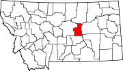
Petroleum County is a county in the U.S. state of Montana. As of the 2020 census, the population was 496, making it the least populous county in Montana and the eighth-least populous in the United States. Its county seat is Winnett. The county's area was partitioned from Fergus County in 1925 to become the last of Montana's 56 counties to be organized.

The 2019–20 North American winter was unusually warm for many parts of the United States; in many areas, neutral ENSO conditions controlled the weather patterns, resulting in strong El Niño like conditions and the sixth-warmest winter on record, and many areas in the Northeastern United States saw one of the least snowy winters in years. In fact, Baltimore and Islip saw no snow in February for the first time. Some notable events still occurred, such as a powerful blizzard that impacted the Western United States in late November, a series of cold shots in January and February, a snowstorm within the Texas Panhandle and a late-season blizzard in the High Plains.