The geography of France consists of a terrain that is mostly flat plains or gently rolling hills in the north and west and mountainous in the south and the east.
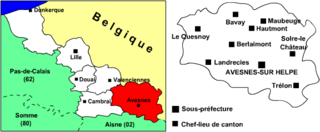
The arrondissement of Avesnes-sur-Helpe is an arrondissement of France in the Nord department in the Hauts-de-France region. It has 151 communes.
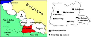
The arrondissement of Cambrai is an arrondissement of France in the Nord department in the Hauts-de-France region. It has 116 communes.

The arrondissement of Douai is an arrondissement of France in the Nord department in the Hauts-de-France region. It has 64 communes.

The arrondissement of Lille is an arrondissement of France in the Nord department in the Hauts-de-France region. It has 124 communes.
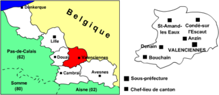
The arrondissement of Valenciennes is an arrondissement of France in the Nord department in the Hauts-de-France region. It has 82 communes.

Parța is a commune in Timiș County, Romania. It is composed of a single village, Parța, and was part of Șag commune until 2004. At the 2011 census, 84.8% were Romanians, 5.8% Hungarians, 4.7% Roma and 2.1% Germans. 52.4% were Romanian Orthodox, 22.9% Greek-Catholic, 11.9% Pentecostal and 8.6% Roman Catholic.
Provița de Sus is a commune in Prahova County, Romania. It is composed of four villages: Izvoru, Plaiu, Provița de Sus and Valea Bradului.
Tindirma is a village and commune of the Cercle of Diré in the Tombouctou Region of Mali. As of 1998 the commune had a population of 3,419.
Forenville is a former commune in the Nord department in northern France, merged in 1964 with Séranvillers to create Séranvillers-Forenville
Séranvillers is a former commune in the Nord department in northern France, merged in 1964 with Forenville to create Séranvillers-Forenville
Hellemmes is a former commune in the Nord department in northern France, since 1977 an associated part of Lille.
Walincourt is a former commune in the Nord department in northern France, merged in October 1972 with Selvigny to create Walincourt-Selvigny
Wazemmes is a former commune in the Nord department in northern France, merged into Lille in 1858.

The Communauté de communes Cœur d’Ostrevent is a federation of municipalities in the Nord département and in the Nord-Pas-de-Calais région of France.
The canton of Anzin is an administrative division of the Nord department, northern France. Its borders were modified at the French canton reorganisation which came into effect in March 2015. Its seat is in Anzin.
The canton of Faches-Thumesnil is an administrative division of the Nord department, northern France. It was created at the French canton reorganisation which came into effect in March 2015. Its seat is in Faches-Thumesnil.
The canton of Maubeuge is an administrative division of the Nord department, northern France. It was created at the French canton reorganisation which came into effect in March 2015. Its seat is in Maubeuge.
The canton of Saint-Amand-les-Eaux is an administrative division of the Nord department, northern France. It was created at the French canton reorganisation which came into effect in March 2015. Its seat is in Saint-Amand-les-Eaux.
The canton of Avesnes-sur-Helpe is an administrative division of the Nord department, northern France. It was created at the French canton reorganisation which came into effect in March 2015. Its seat is in Avesnes-sur-Helpe.