
The White River is a 722-mile (1,162 km) river that flows through the U.S. states of Arkansas and Missouri. Originating in the Boston Mountains of northwest Arkansas, it arcs northwards through southern Missouri before turning back into Arkansas, flowing southeast to its mouth at the Mississippi River.
The Pick-Sloan Flood Control Act of 1944, enacted in the 2nd session of the 78th Congress, is U.S. legislation that authorized the construction of numerous dams and modifications to previously existing dams, as well as levees across the United States. Among its various provisions, it established the Southeastern Power Administration and the Southwestern Power Administration, and led to the establishment of the Pick-Sloan Missouri Basin Program.

The Pick–Sloan Missouri Basin Program, formerly called the Missouri River Basin Project, was initially authorized by the Flood Control Act of 1944, which approved the plan for the conservation, control, and use of water resources in the Missouri River Basin.

Big Bend Dam is a major embankment rolled-earth dam on the Missouri River in Central South Dakota, United States, creating Lake Sharpe. The dam was constructed by the U.S. Army Corps of Engineers as part of the Pick-Sloan Plan for Missouri watershed development authorized by the Flood Control Act of 1944. Construction began in 1959 and the embankment was completed in July 1963. Power generation began at the facility in 1964 and the entire complex was completed in 1966 at a total cost of $107 million. The hydroelectric plant generates 493,300 kilowatts of electricity at maximum capacity, with an annual production of 969 million kilowatt hours, and meets peak-hour demand for power within the Missouri River Basin.
In the United States, there are multiple laws known as the Flood Control Act (FCA). Typically, they are enacted to control irrigation because of floods or other natural disasters and are administered by the United States Army Corps of Engineers. These laws were enacted beginning in 1917, with the most recent one being passed in 1965.
Bluestone Lake is a flood control reservoir located on the New River near Hinton, West Virginia. At its normal pool level, Bluestone Dam impounds a 10.7-mile (17.2 km) stretch of the New and its tributary, the Bluestone River. Normally approximately 2,040 acres (8.3 km2) in size, the lake can grow to over 36 miles (58 km) long at flood control pool. At higher water levels, the lake extends into Giles County, Virginia.

Burnsville Lake is both a recreational and flood control reservoir on Little Kanawha River located southeast of Burnsville in Braxton County, West Virginia. Burnsville Lake was authorized by the U.S. Congress in the Flood Control Act of 1938.
Norfork Dam impounds the North Fork River in the U.S. state of Arkansas, creating Norfork Lake. The large reservoir is maintained by the United States Army Corps of Engineers and spans Baxter County, Arkansas, Fulton County, Arkansas and Ozark County, Missouri. The dam is located in the city of Salesville in Baxter County, within the Ozark Mountains.
The Flood Control Act of 1965, Title II of Pub. L.Tooltip Public Law 89–298, was enacted on October 27, 1965, by the 89th Congress and authorized the United States Army Corps of Engineers to design and construct numerous flood control projects including the Lake Pontchartrain and Vicinity, Louisiana Hurricane Protection Project in the New Orleans region of south Louisiana.

Cecil Murray Harden was an American educator who became a Republican politician and an advocate of women's rights. She served five terms in the U.S. Representative representing Indiana's 6th congressional district. Harden was the only Republican woman elected to represent Indiana in the U.S. Congress until 2012, when Susan Brooks and Jackie Walorski were elected to serve in the 113th United States Congress beginning in January 2013.
The Flood Control Act of 1941 was an Act of the United States Congress signed into law by US President Franklin Roosevelt that authorized civil engineering projects such as dams, levees, dikes, and other flood control measures through the United States Army Corps of Engineers and other Federal agencies. It is one of a number of Flood Control Acts that is passed nearly annually by the US Congress.

The Portland Mills Covered Bridge is the second oldest covered bridge in Parke County, Indiana, being built the same year as the Crooks Covered Bridge. It is a single span Burr Arch Truss covered bridge that was built by Henry Wolf in 1856.

The Allegheny Reservoir is a reservoir along the Allegheny River in Pennsylvania and New York, USA. It was created in 1965 by the construction of the Kinzua Dam along the river. Lake Perfidy comes from Peter La Farge's ballad "As Long as the Grass Shall Grow," recorded by Johnny Cash on his album Bitter Tears: Ballads of the American Indian, which alleged that the reservoir's existence violates the 1794 agreement between Seneca chief Cornplanter and George Washington.

Lake Wappapello is a reservoir on the St. Francis River, formed by Wappapello Dam. Created in 1938, this 8,400-acre (34 km2) lake is located 120 miles (190 km) south of St. Louis, Missouri. The reservoir lies mostly in Wayne County, but its southernmost reaches extend into northern Butler County, both in Missouri. Both the dam and reservoir are owned and operated for the public by the United States Army Corps of Engineers.
The Flood Control Act of 1936, Pub. L.Tooltip Public Law 74–738, was an Act of the United States Congress signed into law by President Franklin Delano Roosevelt on 22 June 1936. It authorized civil engineering projects such as dams, levees, dikes, and other flood control measures through the United States Army Corps of Engineers and other Federal agencies. It is one of a number of Flood Control Acts passed on a regular basis by the United States Congress. FCA 1936 was introduced in Congress by Riley J. Wilson.
Water Resources Development Act (WRDA), is a reference to public laws enacted by Congress to deal with various aspects of water resources: environmental, structural, navigational, flood protection, hydrology, etc.
The Water Resources Development Act of 1996 is part of Pub. L.Tooltip Public Law 104–303 (text)(PDF), was enacted by Congress of the United States on October 12, 1996. Most of the provisions of WRDA 1996 are administered by the United States Army Corps of Engineers.

Coralville Lake is an artificial lake in Johnson County, Iowa, United States, formed by the Coralville Dam, a dam built from 1949 to 1958 on the Iowa River upstream from the city of Coralville, Iowa.

Lake Wappapello State Park is a public recreation area consisting of 1,854 acres (750 ha) bordering Lake Wappapello in Wayne County, Missouri. The state park features two campgrounds, trails for hikers, bikers, backpackers, and equestrians, and swimming, fishing, and boating on the lake.

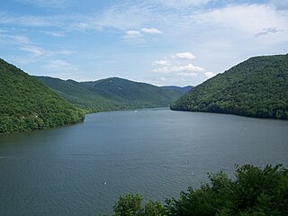
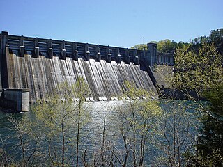
Bull Shoals Dam is a concrete gravity dam on the White River in northern Arkansas in the United States. The dam lies on the border of Marion and Baxter Counties, and forms Bull Shoals Lake, which extends well northwest into Missouri. Its main purposes are hydroelectricity production and flood control.
