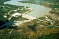
Coralville Dam on June 15, 2008, with the main control gates fully opened, and water flowing over the concrete emergency spillway (left) at about 5ft (1.5m) deep
The lake has a capacity of 461,200acre⋅ft (568,900,000m3) of water, equal to 137.18 billion gallons at its "100 year flood" level of 712-foot (217m).[2]:2
Floods
Water first flowed over the 712-foot (217m) emergency spillway on July 5, 1993 (seeGreat Flood of 1993), reaching a then-record crest.[2]:2 This flood uncovered what is now the Devonian Fossil Gorge.[1]
The 1993 record was surpassed by the June 2008 Midwest floods,[3] when water again flowed over the 712-foot (217m) emergency spillway on June 12, 2008, and the reservoir crested at 717 feet (219m) early in the morning on June 15, 2008.[4]
Lake Macbride is formed by another dam just up from the Coralville reservoir. This dam was overtopped by floodwaters in the flood of 2008, and the lake effectively became part of Coralville Lake.[5]
Recreation and public use
The lake and surrounding shoreline have been extensively developed for public recreational use, including hiking, biking, camping, fishing and boating.[6] There are 11 recreation areas, 4 swimming beaches, 3 marinas, 18 boat ramps, 3 campgrounds (total of 620 campsites), 7 large picnic shelters, 2 disc golf courses, and 7 trails (total of 29 miles).[7]
Photos
Coralville Dam and Reservoir near Coralville, Iowa.
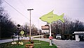
A tackle shop near Coralville Dam.
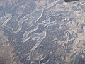
Coralville Lake as seen from the airplane during winter
↑ "Coralville Lake"(PDF). U.S. Army Corps of Engineers, Rock Island District. November 2014. p.2. Archived from the original(PDF) on February 20, 2013. Retrieved February 5, 2024.
This page is based on this Wikipedia article Text is available under the CC BY-SA 4.0 license; additional terms may apply. Images, videos and audio are available under their respective licenses.