Related Research Articles
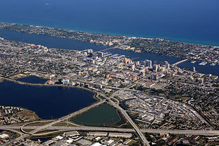
Palm Beach County is a county in the southeastern part of Florida, located in the Miami metropolitan area. It is Florida's third-most populous county after Miami-Dade County and Broward County and the 26th-most populous in the United States, with 1,492,191 residents as of the 2020 census. Its county seat and largest city is West Palm Beach, which had a population of 117,415 as of 2020. Named after one of its oldest settlements, Palm Beach, the county was established in 1909, after being split from Miami-Dade County. The county's modern-day boundaries were established in 1963.

Pembroke Pines is a city in southern Broward County, Florida, United States. The city is located 22 miles (35 km) north of Miami. It is a suburb of and the fourth-most populous city in the Miami metropolitan area. The population of Pembroke Pines was 171,178 at the 2020 census.
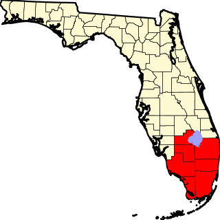
The Miami metropolitan area is a coastal metropolitan area in southeastern Florida. It is the ninth-largest metropolitan statistical area (MSA) in the United States, the fifth-largest metropolitan area in the Southern United States, and the largest metropolitan area in Florida. It is also known as South Florida, SoFlo, SoFla, the Gold Coast, Southeast Florida, the Tri-County Area, or Greater Miami, and officially as the Miami–Fort Lauderdale–West Palm Beach Metropolitan Statistical Area. With a population of 6.18 million, its population exceeds 31 of the nation's 50 states as of 2023. It comprises the three most populated counties in the state, Miami-Dade County, Broward County, and Palm Beach County, which rank as the first, second, and third-most populous counties in the state, respectively. Miami-Dade County, with 2,701,767 people in 2020, is the seventh-most populous county in the United States.
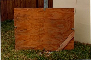
Hurricane coverings, commonly known as shutters, are used in hurricane mitigation to protect houses and other structures from damage caused by storms. Hurricane shutters are used to prevent windows from being broken by flying objects during a storm. Although the negative pressure caused by high-speed wind flowing over a building roof can cause the roof to fail with the building envelope intact, broken windows allow the air pressure to rise inside a building, creating an even greater pressure difference and increasing the likelihood of roof failure.

Cyclone mitigation encompasses the actions and planning taken before a tropical cyclone strikes to mitigate damage and injury from the storm. Knowledge of tropical cyclone impacts on an area help plan for future possibilities. Preparedness may involve preparations made by individuals as well as centralized efforts by governments or other organizations. Tracking storms during the tropical cyclone season helps individuals know current threats. Regional Specialized Meteorological Centers and Tropical Cyclone Warning Centers provide current information and forecasts to help individuals make the best decision possible.

Hurricane Wilma was the most intense tropical cyclone in the Atlantic basin and the second-most intense tropical cyclone in the Western Hemisphere, both based on barometric pressure, after Hurricane Patricia in 2015. Wilma's rapid intensification led to a 24-hour pressure drop of 97 mbar, setting a new basin record. At its peak, Hurricane Wilma's eye contracted to a record minimum diameter of 2.3 mi (3.7 km). In the record-breaking 2005 Atlantic hurricane season, Wilma was the twenty-second storm, thirteenth hurricane, sixth major hurricane, fourth Category 5 hurricane, and the second costliest.
The Homestead Extension of Florida's Turnpike (HEFT), designated as unsigned State Road 821 (SR 821), is the southern extension of Florida's Turnpike, a controlled-access toll road in the U.S. state of Florida maintained by Florida's Turnpike Enterprise (FTE). Spanning approximately 48 miles (77 km) along a north–south axis, it supplements the 265-mile (426 km) mainline to form the complete 309-mile (497 km) turnpike. The extension begins at its southern terminus at U.S. Route 1 (US 1) in Florida City, and transitions into the SR 91 mainline in Miramar at its northern end. Despite their designations as different state roads, the mainline and the extension are continuous in their exit numbering.

Tropical Storm Leslie was a weak, short-lived tropical cyclone that was never well-organized; however, its precursor was costlier than any other tropical cyclone in the 2000 Atlantic hurricane season. The twelfth named storm of the season, Leslie formed on October 4 over eastern Florida as a subtropical cyclone, out of a trough of low pressure. Strengthening over open waters, it attained enough tropical characteristics to be reclassified as Tropical Storm Leslie on October 5. The storm reached peak winds of 45 mph (75 km/h) before wind shear weakened it, and on October 7 transitioned into an extratropical cyclone over the open Atlantic Ocean. Leslie lasted three more days before losing its identity.
The Air Movement and Control Association International, Inc. (AMCA) is an American trade body that sets standards for Heating, Ventilation and Air Conditioning (HVAC) equipment. It rates fan balance and vibration, aerodynamic performance, air density, speed and efficiency.

Herbert Seymour Saffir was an American civil engineer who co-developed the Saffir–Simpson Hurricane Scale for measuring the intensity of hurricanes. As recently as 2005 Saffir was the principal of Saffir Engineering in Coral Gables, Florida. He also published articles on designing buildings for high wind resistance.

The effects of Hurricane Wilma in Florida resulted in the storm becoming one of the costliest tropical cyclones in Florida history. Wilma developed in the Caribbean Sea just southwest of Jamaica on October 15 from a large area of disturbed weather. After reaching tropical storm intensity on October 17 and then hurricane status on October 18, the system underwent explosive intensification, peaking as the strongest tropical cyclone ever recorded in the Atlantic basin. Wilma then slowly weakened while trekking to the northwest and fell to Category 4 intensity by the time it struck the Yucatán Peninsula on October 22. Thereafter, a strong cold front swept the storm northeastward into Florida on October 24, with landfall occurring near Cape Romano as a Category 3 hurricane with winds of 120 mph (190 km/h). Wilma continued rapidly northeastward into the Atlantic Ocean and became extratropical on October 26.
The National Weather Service Miami, Florida is a local weather forecast office of the National Weather Service (NWS) that serves six counties in South Florida – Broward, Collier, Glades, Hendry, Miami-Dade, and Palm Beach – as well as the mainland portion of Monroe County. This office was originally established in 1879 as a Signal Corps station near the Jupiter Inlet Light, before becoming a Weather Bureau Office (WBO) in 1891. The WBO at Jupiter was moved southward to Miami in 1911, due to the city's rapidly growing population. In 1930, a separate Weather Bureau Airport Station (WBAS) was established at the Miami Municipal Airport. The WBAS was later moved to the Miami International Airport in 1942 and remained there until ceasing operations in 1975.

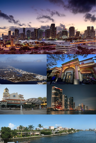
Miami-Dade County is a county located in the southeastern part of the U.S. state of Florida. The county had a population of 2,701,767 as of the 2020 census, making it the most populous county in Florida and the seventh-most populous county in the United States. It is Florida's third largest county in terms of land area with 1,946 square miles (5,040 km2). The county seat is Miami, the core of the nation's ninth-largest and world's 65th-largest metropolitan area with a 2020 population of 6.138 million people, exceeding the population of 31 of the nation's 50 states as of 2022.
Tornadoes, cyclones, and other storms with strong winds damage or destroy many buildings. However, with proper design and construction, the damage to buildings by these forces can be greatly reduced. A variety of methods can help a building survive strong winds and storm surge.

The Miami metropolitan area composed of the three counties of Miami-Dade, Broward, and Palm Beach, also known collectively as South Florida, is home to a wide variety of public and private transportation systems.

Hurricane Andrew at the time was the costliest disaster in Florida, as well as the then-costliest on record in the United States. Hurricane Andrew formed from a tropical wave on August 16, 1992, in the tropical Atlantic Ocean. It moved west-northwest and remained weak for several days due to strong wind shear. However, after curving westward on August 22, the storm rapidly intensified to reach peak winds of 175 mph (282 km/h). Following its passage through The Bahamas, Andrew made landfall near Homestead, Florida as a Category 5 hurricane on August 24. Eventually, Andrew struck southern Louisiana before it dissipated over the eastern United States on August 28.

Hurricane Andrew was a compact, but very powerful and destructive Category 5 Atlantic hurricane that struck The Bahamas, Florida, and Louisiana in August 1992. It is the most destructive hurricane to ever hit Florida in terms of structures damaged or destroyed, and remained the costliest in financial terms until Hurricane Irma surpassed it 25 years later. Andrew was also the strongest landfalling hurricane in the United States in decades and the costliest hurricane to strike anywhere in the country, until it was surpassed by Katrina in 2005. In addition, Andrew is one of only four tropical cyclones to make landfall in the continental United States as a Category 5, alongside the 1935 Labor Day hurricane, 1969's Camille, and 2018's Michael. While the storm also caused major damage in The Bahamas and Louisiana, the greatest impact was felt in South Florida, where the storm made landfall as a Category 5 hurricane, with 1-minute sustained wind speeds as high as 165 mph (266 km/h) and a gust as high as 174 mph (280 km/h). Passing directly through the cities of Cutler Bay and Homestead in Dade County, the hurricane stripped many homes of all but their concrete foundations and caused catastrophic damage. In total, Andrew destroyed more than 63,500 houses, damaged more than 124,000 others, caused $27.3 billion in damage, and left 65 people dead.

Miami-Dade County Public Schools (M-DCPS) is the public school district serving Miami-Dade County in the U.S. state of Florida. Founded in 1885, it is the largest school district in Florida, the largest in the Southeastern United States, and the third-largest in the United States with a student enrollment of 356,589 as of August 30, 2021.

Hurricane Floyd in 1999 threatened Florida as a major hurricane roughly three times as large as Hurricane Andrew. Floyd originated from a tropical wave well east of the Lesser Antilles on September 7. While approaching the Bahamas, the storm strengthened significantly between September 12 and September 13. On the latter day, Floyd peaked as a strong Category 4 hurricane on the Saffir–Simpson scale. However, upon moving closer to the Bahamas, the storm fluctuated in intensity between a Category 3 and a Category 4 hurricane. A subtropical ridge eroded by a mid- to upper-tropospheric trough over the eastern United States caused Floyd to curve northwestward over the Abaco Islands and later to northeast, avoiding a potentially catastrophic landfall in Florida. The storm made its closest approach to Florida early on September 15, passing about 110 mi (180 km) east of Cape Canaveral.

Hurricane Matthew was the strongest tropical cyclone to affect the First Coast of Florida since 1898. A late-season Category 5 hurricane in late 2016, Matthew was the first hurricane to threaten the Floridan coastline as a major hurricane since Wilma in 2005. While the center of the storm did not actually cross the coastline, the western eyewall of the storm paralleled the coast, with the most eastern portions receiving winds up to Category 2 strength. The storm caused at least three direct deaths and eleven indirect, and up to $2.77 billion in damages.
References
- Analysis of Laws Relating to Florida Coastal Zone Management. University of Florida, Center for Governmental Responsibility. 1976.
- State Consumer Action: Summary '74. pp 133 & 134.
- ↑ "Florida Building Commission" . Retrieved August 30, 2023.
- ↑ "Allegion Windstorm solutions" (PDF). Allegion. March 16, 2016. p. 5. Retrieved February 8, 2021.
- ↑ "Florida". ICC. January 8, 2015. Retrieved February 8, 2021.
- 1 2 "Changes to the Wind Speed Maps and Wind Design – 2010 Florida Building Codes" (PDF). Retrieved October 9, 2016.
- ↑ "Palm Beach County News - Sun Sentinel". www.sun-sentinel.com. Retrieved February 10, 2017.
- ↑ Services, Miami-Dade County Online. "Miami-Dade County - Building - Product Control Search". www.miamidade.gov. Retrieved October 9, 2016.
- ↑ "Testing Application Standard (TAS) 201-94" . Retrieved October 9, 2016.
- ↑ "Testing Application Standard (TAS) 202-94" . Retrieved October 9, 2016.
- ↑ "Testing Application Standard (TAS) 203-94" . Retrieved October 9, 2016.