Interstate 96 (I-96) is an east–west Interstate Highway that runs for approximately 192 miles (309 km) entirely within the Lower Peninsula of the US state of Michigan. The western terminus is at an interchange with US Highway 31 (US 31) and Business US 31 on the eastern boundary of Norton Shores southeast of Muskegon, and the eastern terminus is at I-75 near the Ambassador Bridge in Detroit. From Grand Rapids through Lansing to Detroit, the freeway parallels Grand River Avenue, never straying more than a few miles from the decommissioned US 16. The Wayne County section of I-96 is named the Jeffries Freeway from its eastern terminus to the junction with I-275 and M-14. Though maps still refer to the freeway as the Jeffries, the portion within the city of Detroit was renamed by the state legislature as the Rosa Parks Memorial Highway in December 2005 in honor of the late civil rights pioneer. There are four auxiliary Interstates as well as two current and four former business routes associated with I-96.

Route 110, consisting of State Route 110 (SR 110) and Interstate 110 (I-110), is a state and auxiliary Interstate Highway in the Los Angeles metropolitan area of the US state of California. The entire route connects San Pedro and the Port of Los Angeles with Downtown Los Angeles and Pasadena. The southern segment from San Pedro to I-10 in downtown Los Angeles is signed as I-110, while the northern segment to Pasadena is signed as SR 110. The entire length of I-110, as well as SR 110 south of the Four Level Interchange with US Route 101 (US 101), is the Harbor Freeway, and SR 110 north from US 101 to Pasadena is the historic Arroyo Seco Parkway, the first freeway in the western United States.

Interstate 215 (I-215) is a 54.5-mile-long (87.7 km) north–south auxiliary Interstate Highway in the Inland Empire region of Southern California. It has portions designated as the Barstow, Escondido, and Armed Forces Freeways. I-215 is a bypass auxiliary route of I-15, running from Murrieta to northern San Bernardino. While I-215 connects the city centers of both Riverside and San Bernardino, its parent I-15 runs to the west through Corona and Ontario.

M-5, commonly referred to as Grand River Avenue and the northern section as the Haggerty Connector, is a 27.9-mile-long (44.9 km) state trunkline highway in the Metro Detroit area of the US state of Michigan. The highway runs through suburbs in Oakland and Wayne counties in addition to part of Detroit itself. It starts in Commerce Township as a north–south divided highway and freeway called the Haggerty Connector and connects with Interstate 96 (I-96) in Novi. The freeway then turns southeasterly to bypass the suburb of Farmington as an east–west highway. The freeway ends on the southeast side of Farmington, and M-5 follows Grand River Avenue as boulevard into Detroit. The eastern terminus is at the five-way intersection between Grand River Avenue, Cass Avenue, and Middle Street in Downtown Detroit, where it had been extended to in May 2016 from an interchange with I-96 on the northwest side of the city. The trunkline passes between suburban residential subdivisions and along urban commercial areas while serving 17,200–68,800 vehicles on average each day.

Arizona State Route 51 (SR 51), also known as the Piestewa Freeway, is a numbered state highway in Phoenix, Arizona. It connects Interstate 10 and Loop 202 just outside Downtown Phoenix with Loop 101 on the north side of Phoenix, making it one of the area's major freeways. It is a largely north–south route and is known for traversing the Piestewa Peak Recreation Area. The peak was named after Lori Piestewa, the first Native American woman to die in combat in the U.S. military. Prior to this time, the freeway was known as the Squaw Peak Parkway, a name considered offensive by Native Americans. Rapid growth and increased traffic demand on the east side of Metro Phoenix made the Piestewa Freeway necessary.

Interstate 264 (I-264) is an Interstate Highway in the US state of Virginia. It serves as the primary east–west highway through the South Hampton Roads region in southeastern Virginia. The route connects the central business districts of Chesapeake, Portsmouth, Norfolk, and Virginia Beach and serves as the most direct link between those cities and the resort beaches along Virginia's Atlantic coast.

Interstate 195 (I-195) is an auxiliary Interstate Highway in the US state of Virginia. Known as the Beltline Expressway, the highway runs 3.24 miles (5.21 km) from State Route 195 (SR 195), a toll road that continues south into Downtown Richmond, north to I-64 and I-95 on the northern edge of Richmond. I-195 passes through the West End of Richmond and connects I-64 and I-95 with US Route 33 (US 33) and US 250, which follow Broad Street, and with SR 76, a toll road that links Richmond with the Southside of the metropolitan area.

State Route 76 is a controlled-access toll road in the U.S. state of Virginia. Known as the Powhite Parkway, the state highway runs 13.04 miles (20.99 km) from SR 652 near Midlothian north to Interstate 195 (I-195) in Richmond. SR 76 connects SR 288, U.S. Route 60, and SR 150 in Chesterfield County with I-195 and SR 195 west of Downtown Richmond. The highway includes a pair of mainline barrier toll plazas and ramp toll plazas at most interchanges, all of which accept E-ZPass. SR 76 is maintained by the Virginia Department of Transportation (VDOT) in Chesterfield County and the Richmond Metropolitan Authority in the city of Richmond. The Richmond section of the freeway was constructed in the early 1970s; the highway was extended to its current terminus in Chesterfield County in the late 1980s.

State Route 275 is an unsigned state highway connecting West Sacramento, California and Downtown Sacramento. Since 1996, the highway has been legally defined to be the length of the Tower Bridge crossing the Sacramento River. Prior to that year, SR 275 was also known as the West Sacramento Freeway, and was a short spur connecting Interstate 80 Business / U.S. Route 50 in West Sacramento, and the Tower Bridge. SR 275 also extended east into Sacramento along the Capitol Mall from the bridge to 9th Street, just west of the California State Capitol. West Sacramento completed a project to replace the freeway with a pedestrian-friendly street named Tower Bridge Gateway.

The Foothill Freeway is a freeway in the Los Angeles metropolitan area, California, United States, running from the Sylmar district of Los Angeles east to Redlands. The western segment is signed as Interstate 210 (I-210) from its western end at I-5 to SR 57 in Glendora, while the eastern segment is signed as State Route 210 (SR 210) to its eastern terminus at I-10. Under the California Streets and Highways Code, the entire Foothill Freeway is legally referred to as Route 210.

Interstate 275 (I-275), located in Florida, is a 60-mile-long (97 km) auxiliary Interstate Highway serving the Tampa Bay area. Its southern terminus is at I-75 near Palmetto, where I-275 heads west towards the Sunshine Skyway Bridge crossing over Tampa Bay. From that point, I-275 passes through St. Petersburg before crossing Tampa Bay again on the Howard Frankland Bridge, then continues through the city of Tampa, where it connects to an interchange with I-4 in Downtown Tampa. After the interchange, I-275 passes north through the Tampa suburbs to its northern terminus at I-75 in Wesley Chapel.

Interstate 275 (I-275) is an auxiliary Interstate Highway in the US state of Michigan that acts as a western bypass of the Detroit metropolitan area. The Michigan Department of Transportation (MDOT) maintains the highway as part of the larger State Trunkline Highway System. The freeway runs through the western suburbs near Detroit Metropolitan Wayne County Airport, and crosses several rivers and rail lines in the area. The southern terminus is the interchange with I-75 near Newport, northeast of Monroe. MDOT considers the Interstate to run to an interchange with I-96, I-696 and M-5 on the Farmington Hills–Novi city line, running concurrently with I-96 for about five miles (8.0 km). This gives a total length of about 35.03 miles (56.38 km), which is backed up by official signage. According to the Federal Highway Administration (FHWA), the length is 29.97 miles (48.23 km) because that agency considers I-275 to end at the junction with I-96 and M-14 along the boundary between Livonia and Plymouth Township. All other map makers, like the American Automobile Association, Rand McNally and Google Maps follow MDOT's practice.

Interstate 240 (I-240) is a 19.27-mile-long (31.01 km) auxiliary Interstate Highway in the US state of Tennessee that forms a bypass around the southern and eastern neighborhoods of Memphis. Combined, I-240 and its parent, I-40, form a contiguous beltway around most of Memphis. I-240 runs from I-40 in Midtown Memphis to I-40 and Sam Cooper Boulevard in East Memphis. Throughout its length, it provides access to I-55, multiple U.S. and state routes, and the Memphis International Airport. The segment between the western terminus and I-55 is a north–south route, and the segment between I-55 and the eastern terminus runs east to west. Throughout its length, I-240 is designated as the Dr. Martin Luther King Jr. Expressway, the W.B. Fowler Sr. Expressway, and the Avron B. Fogelman Expressway.

Interstate 80 (I-80) is a transcontinental Interstate Highway in the United States, stretching from San Francisco, California, to Teaneck, New Jersey. The segment of I-80 in California runs east from San Francisco across the San Francisco–Oakland Bay Bridge to Oakland, where it turns north and crosses the Carquinez Bridge before turning back northeast through the Sacramento Valley. I-80 then traverses the Sierra Nevada, cresting at Donner Summit, before crossing into the state of Nevada within the Truckee River Canyon. The speed limit is at most 65 mph (105 km/h) along the entire route instead of the state's maximum of 70 mph (110 km/h) as most of the route is in either urban areas or mountainous terrain. I-80 has portions designated as the Eastshore Freeway and Alan S. Hart Freeway.

State Route 42 (SR 42) is a decommissioned state highway in the southern region part of the U.S. state of California, running along Manchester Avenue, Manchester Boulevard and Firestone Boulevard in Los Angeles and the cities south of it. In its final official routing that lasted from 1968 to 2000, SR 42 ran from State Route 1 west of Inglewood east to what was then a direct interchange with Interstate 5 in Norwalk. Though signed as SR 42, it was officially Route 105 until it was replaced by the parallel Interstate 105 on October 14, 1993. The entire route was deleted from the California Freeway and Expressway System in 2000, with the remaining portion of SR 42 being relinquished to local jurisdictions in that year. The direct interchange with I-5 was later demolished in 2013 in favor widening that portion of the Interstate. However, some SR 42 signs may still remain along the route.

State Road 686 is an east–west route in Pinellas County, running from U.S. Route 19 Alternate in Largo east to an intersection with SR 687 and SR 694 in St. Petersburg, Florida. Originally, SR 686 extended further west, ending at Gulf Boulevard in Belleair Beach, next to the shores of the Gulf of Mexico.

Route 15, consisting of the contiguous segments of State Route 15 (SR 15) and Interstate 15 (I-15), is a major north–south state highway and Interstate Highway in the U.S. state of California, connecting San Bernardino, Riverside, and San Diego Counties. The route consists of the southernmost 289.24 miles (465.49 km) of I-15, which extends north through Nevada, Arizona, Utah, Idaho, and Montana to the Canada–US border. It is a major thoroughfare for traffic between San Diego and the Inland Empire, as well as between Southern California, Las Vegas, Nevada, and the Intermountain West.
The metropolitan area of Phoenix in the U.S. state of Arizona contains one of the nation's largest and fastest-growing freeway systems, with over 1,405 lane miles (2,261 km) as of 2005.

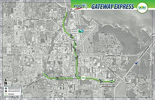
The Gateway Expressway is a controlled-access toll road in Pinellas County, Florida completed in April 2024 at a cost of $598 million. The project consists of two branches: an elevated highway to be designated State Road 690 above 118th Avenue North between Interstate 275 (I-275) and U.S. Highway 19 and a raised highway in the median of SR 686 from 118th Avenue North to the Bayside Bridge. Construction was approved in February 2014, began in November 2017, and completed on April 26, 2024.


