List of U.S. Highways in Florida

Last updated

United States Numbered Highways of the Florida State Highway System
US 1.svg US 98.svg US 441.svg
Standard US Highway shields in Florida
System information
NotesState Roads are generally state-maintained.
Highway names
Interstates Interstate X (I-X)
US Highways U.S. Highway X (US X)
State State Road X (SR X)
System links

The U.S. Highways in Florida are the segments of the United States Numbered Highway System maintained by the Florida Department of Transportation (FDOT). Prior to 1993, Florida used colored shields for its U.S. Highways. There are 18 current U.S. Highways in Florida and 2 former U.S. Highways.

Contents

Mainline highways

NumberLength (mi) [1] Length (km)Southern or western terminusNorthern or eastern terminusFormedRemovedNotes
US 1.svg US 1 545.03877.14Whitehead Street / Fleming Street in Key West US 1  / US 23  / US 301  / SR 4  / SR 15 near Folkston, GA 01926-01-011926current
US 17.svg US 17 317.07510.27 US 41  / SR 35  / SR 45 in Punta Gorda US 17  / SR 25 near Kingsland, GA 01926-01-011926current
US 19.svg US 19 261.968421.597 US 41  / SR 45  / SR 55 in Memphis US 19  / SR 3  / SR 300 near Thomasville, GA 01926-01-011926current
US 23.svg US 23 37.65660.601 US 1  / US 17  / SR 5  / SR 15  / SR 115  / SR 139  / SR 228 in Jacksonville US 1  / US 23  / US 301  / SR 4  / SR 15 near Folkston, GA 01926-01-011926current
US 27.svg US 27 496.352798.801 US 1  / SR 5  / SR 948 in Miami US 27  / SR 1  / SR 111 near Calvary, GA 01926-01-011926current
US 29.svg US 29 43.670.2 US 90  / US 98  / SR 10A  / SR 30  / SR 95 in Pensacola US 29  / SR 15  / SR 113 in Flomaton, AL 01926-01-011926current
US 41.svg US 41 478.92770.75 US 1  / SR 5  / SR 90 in Miami US 41  / SR 7 near Lake Park, GA 01926-01-011926currentSigned as east–west from Naples to Miami
US 90.svg US 90 408.723657.776 US 90  / SR 16 near Seminole, AL SR A1A  / SR 212 in Jacksonville Beach 01926-01-011926current
US 92.svg US 92 181.363291.875 US 19 Alt.  / SR 595  / SR 687 in St. Petersburg SR A1A in Daytona Beach 01926-01-011926current
US 94 (1948).svg US 94 264.16425.12 US 41 in Naples US 1 in Miami 01926-01-01192601949-01-011949Resigned as US 41
US 98.svg US 98 670.9591,079.804 US 98  / SR 42 in Lillian, AL SR A1A  / SR 700 in Palm Beach 01933-01-011933currentSigned as north–south from Perry to Palm Beach
US 129.svg US 129 87.881141.431 US 19  / US 27 Alt.  / US 98  / SR 55 in Chiefland US 129  / SR 11 in Statenville, GA 01941-01-011941current
US 192.svg US 192 74.746120.292 US 27  / SR 25 in Four Corners SR A1A  / SR 500 in Indialantic 01926-01-011926current
US 221.svg US 221 39.97864.338 US 19  / US 27 Alt.  / US 98  / SR 55 in Perry US 221  / SR 76 in Quitman, GA 01930-01-011930current
US 231.svg US 231 66.591107.168 US 98 Bus.  / SR 30  / SR 75 in Panama City US 231  / SR 1 in Madrid, AL 01926-01-011926current
US 301.svg US 301 269.316433.422 US 41  / SR 45  / SR 683 in Sarasota US 1  / US 23  / US 301  / SR 4  / SR 15 near Folkston, GA 01949-01-011949current
US 319.svg US 319 96.791155.770 US 98  / SR 30 in Apalachicola US 319  / SR 35 near Thomasville, GA 01933-01-011933current
US 331.svg US 331 49.35679.431 US 98  / SR 30  / SR 83 in Santa Rosa Beach US 331  / SR 9 near Florala, AL
US 441.svg US 441 433.050696.926 US 41  / SR 7  / SR 90 in Miami US 441  / SR 89 near Fargo, GA 01926-01-011926current
US 541 (1948).svg US 541 5080 US 41  / SR 43  / SR 55 in Palmetto US 41  / SR 685 in Lutz 01931-01-01193101951-01-011951Became US 41 Bus. as well as parts of US 41 and US 301
  •       Former

Special routes

NumberLength (mi)Length (km)Southern or western terminusNorthern or eastern terminusFormedRemovedNotes
Business plate.svg
US 1.svg US 1 Bus.
3.35.3 US 1  / SR 5  / Ponce de Leon Boulevard in St. Augustine US 1 / SR 5  / Dixie Highway in St. Augustine 01959-01-011959current
Alt plate.svg
US 1.svg US 1 Alt.
7.311.7 US 1  / SR 5  / SR 126 in Jacksonville US 1  / US 17  / SR 5  / SR 15  / SR 115 in Jacksonville
US 1 Business (1956).svg
US 1 (FL reversed).svg US 1 Bus.
01960-01-01196001968-01-011968
Alt plate.svg
US 1.svg US 1 Alt.
US 1 Alternate (1956).svg
US 1 (FL reversed).svg US 1 Alt.
US 1  / US 90  / SR 13 near Acosta Bridge US 1  / US 23  / SR 139 in Jacksonville 01958-01-01195801960-01-011960Currently signed as SR 13, and part of SR 211
Truck plate.svg
US 17.svg US 17 Truck
3.35.3 US 17  / US 92  / SR 423  / SR 600 in Winter Park US 17  / US 92  / SR 600  / CR 438A in Maitland
Truck plate.svg
US 17.svg US 17 Truck
Resigned as US 17 / US 92
Alt plate.svg
US 17.svg US 17 Alt.
Alt plate.svg
US 19.svg US 19 Alt.
40.0864.50 US 92  / SR 595  / SR 687 in St. Petersburg US 19  / SR 55  / SR 595 in Holiday 01951-01-011951current
Alt plate.svg
US 19.svg US 19 Alt.
Alt plate.svg
US 27.svg US 27 Alt.
94151 US 27  / US 41  / SR 45  / SR 121  / SR 500 in Williston US 19  / US 27 / US 98  / SR 20  / SR 30  / SR 55 in Perry
US 27 Alternate (1956).svg
US 27 (FL reversed).svg US 27 Alt.
Currently signed as SR 17
Alt plate.svg
US 27.svg US 27 Alt.
Currently signed as SR 17
US 27 Alternate (1956).svg
US 27 (FL reversed).svg US 27 Alt.
US 27  / US 441  / SR 500 in Lady Lake US 27 / US 301  / US 441 / SR 500 in Belleview Now CR 25A in Lake and Marion counties
Business plate.svg
US 41.svg US 41 Bus.
6.510.5 US 41  / SR 45  / SR 82  / SR 867 in Fort Myers US 41 / SR 45 near North Fort Myers
Business plate.svg
US 41.svg US 41 Bus.
2.94.7 US 41  / SR 45  / SR 45A in Venice US 41 / SR 45 / SR 45A in Venice01965-01-011965current
Business plate.svg
US 41.svg US 41 Bus.
5.89.3 US 41  / SR 45  / SR 684 in Bradenton US 41 / SR 45 / SR 55 in Memphis
Business plate.svg
US 41.svg US 41 Bus.
16.726.9 US 41  / SR 45  / SR 676 in Palm River-Clair Mel US 41 / SR 45 / SR 685 in Lutz 01951-01-011951current
Alt plate.svg
US 90.svg US 90 Alt.
12.920.8 US 90 in Beulah US 90 in Ferry Pass
Alt plate.svg
US 90.svg US 90 Alt.
6.710.8 US 90  / SR 10  / SR 212 in Jacksonville US 90 / SR 115  / SR 212 in Jacksonville
Truck plate.svg
US 92.svg US 92 Truck
3.35.3 US 17  / US 92  / SR 423  / SR 600 in Winter Park US 17 / US 92 / SR 600 / CR 438A in Maitland
Business plate.svg
US 92.svg US 92 Bus.
Truck plate.svg
US 92.svg US 92 Truck
Resigned as US 17 / US 92
Business plate.svg
US 98.svg US 98 Bus.
US 98  / SR 292 in Pensacola US 98 in Pensacola
Alt plate.svg
US 98.svg US 98 Alt.
Business plate.svg
US 98.svg US 98 Bus.
Business plate.svg
US 98.svg US 98 Bus.
US 98  / SR 700 near Brooksville US 98 / SR 50  / SR 700 in Brooksville
Business plate.svg
US 98.svg US 98 Bus.
US 98 Truck  / US 301 Truck  / SR 533 in Dade City US 98 Truck / US 301 Truck / SR 533 in Dade City
Truck plate.svg
US 98.svg US 98 Truck
US 98 Bus.  / US 301 Bus.  / SR 35  / SR 39  / SR 700 in Dade City US 98 Bus. / US 301 Bus. / SR 35 / SR 39 / SR 700 in Dade CityResigned as US 98 / US 301
Toll plate.svg
US 98.svg US 98 Toll
By-pass plate.svg
US 98.svg US 98 Byp.
Business plate.svg
US 98.svg US 98 Bus.
Business plate.svg
US 98.svg US 98 Bus.
US 129 Alternate (1956).svg
US 129 (FL reversed).svg US 129 Alt.
US 19  / US 27 Alt.  / US 98  / SR 55 in Old Town US 27  / US 129  / SR 20 in Branford 01959-01-01195901970-01-011970Almost entirely SR 349 today
No image.svgTruck plate.svgNo image.svg
US 221.svg US 221 Truck
US 19  / US 27 Alt.  / US 98  / US 221 in Perry US 221 / CR 359A north of Perry
No image.svgBusiness plate.svgNo image.svg
US 301.svg US 301 Bus.
US 98 Truck  / US 301 Truck  / SR 533 in Dade City US 98 Truck / US 301 Truck / SR 533 in Dade CityCurrently signed as SR 39
No image.svgTruck plate.svgNo image.svg
US 301.svg US 301 Truck
US 98 Bus.  / US 301 Bus.  / SR 35  / SR 39  / SR 700 in Dade City US 98 Bus. / US 301 Bus. / SR 35 / SR 39 / SR 700 in Dade City
US 301 Alternate (1956).svg
US 301 (FL reversed).svg US 301 Alt.
US 301  / US 441  / SR 25  / SR 200 in Ocala US 301 / SR 200 in Citra Now CR 200A
No image.svgAlt plate.svgNo image.svg
US 319.svg US 319 Alt.
No image.svgBusiness plate.svgNo image.svg
US 319.svg US 319 Bus.
No image.svgTruck plate.svgNo image.svg
US 441.svg US 441 Truck
US 41  / US 441  / SR 25 in Lake City US 441 / CR 100A  / CR 250 in Lake CityRuns along US 41, CR 100A, and CR 250
US 441 Business (1956).svg
US 441 (FL reversed).svg US 441 Bus.
US 441  / SR 500 in Tangerine US 441 / SR 19  / SR 44  / SR 500 in Tavares Now signed as CR Old 441 and occasionally CR 500A
US 441 Alternate (1956).svg
US 441 (FL reversed).svg US 441 Alt.
US 27  / US 441  / SR 500 in Lady Lake US 27 / US 301  / US 441 / SR 500 in Belleview Now CR 25A in Lake and Marion counties
US 441 Alternate (1956).svg
US 441 (FL reversed).svg US 441 Alt.
US 301  / US 441  / SR 25  / SR 200 in Ocala US 441 / SR 25 in Derrick Now CR 25A
No image.svgAlt plate.svgNo image.svg
US 541.svg US 541 Alt.
  •       Former

See also

Related Research Articles

<span class="mw-page-title-main">Interstate 4</span> Interstate Highway in Florida, United States

Interstate 4 (I-4) is an Interstate Highway located entirely within the U.S. state of Florida, maintained by the Florida Department of Transportation (FDOT). Spanning 132.298 miles (212.913 km) along a generally southwest–northeast axis, I-4 is entirely concurrent with State Road 400 (SR 400). In the west, I-4 begins at an interchange with I-275 in Tampa. I-4 intersects with several major expressways as it traverses Central Florida, including U.S. Route 41 (US 41) in Tampa; US 301 near Riverview; I-75 near Brandon; US 98 in Lakeland; US 27 in unincorporated Davenport; US 192 in Celebration; Florida's Turnpike in Orlando; and US 17 and US 92 in multiple junctions. In the east, I-4 ends at an interchange with I-95 in Daytona Beach, while SR 400 continues for roughly another 4 mi (6.4 km) and ends at an intersection with US 1 on the city line of Daytona Beach and South Daytona.

<span class="mw-page-title-main">Interstate 595 (Florida)</span> Highway in Florida

Interstate 595 (I-595), also known as the Port Everglades Expressway and as the unsigned State Road 862 (SR 862), is a 12.860-mile (20.696 km) Interstate highway that connects Interstate 75 and Alligator Alley in the west with Florida's Turnpike, Interstate 95, Fort Lauderdale-Hollywood International Airport, US 1, and SR A1A before terminating at Port Everglades in the east. The interstate route was conceived in 1969, and planned as an interstate starting in 1974. Construction began in 1984, with the freeway opening in stages in the late 1980s, with completion in 1991. The reversible tolled express lanes opened in 2014.

<span class="mw-page-title-main">Florida State Highway System</span> Highway system in Florida, United States

The State Highway System of the U.S. state of Florida comprises the roads maintained by the Florida Department of Transportation (FDOT) or a toll authority. The components are referred to officially as state roads, abbreviated as SR.

<span class="mw-page-title-main">Interstate 375 (Florida)</span> Highway in Florida

Interstate 375 (I-375) in St. Petersburg, Florida, also known as North Bay Drive, is a 1.2-mile-long (1.9 km) spur route from I-275 into downtown. It is also designated as the unsigned State Road 592 (SR 592). There is a sibling segment of freeway nearby that is designated I-175.

<span class="mw-page-title-main">Florida State Road 5A</span>

State Road 5A (SR 5A), also known as Nova Road, is a north–south highway that begins and ends at U.S. Highway 1 or US 1, in Port Orange and Ormond Beach, respectively. It is noted that when 5A was built, it was used more as a bypass or beltway, but in recent years with growth reaching far beyond SR 5A, it sees more use as a major thoroughfare that passes through the heart of the region.

<span class="mw-page-title-main">Florida State Road 500</span>

State Road 500 is a state highway running through Florida as a mostly unsigned route under several U.S. Highways. From Chiefland to Williston it is U.S. Highway 27 Alternate. From Williston to Ocala, it is US 27. From Ocala to Holopaw, it is US 441. From Kissimmee to Indialantic it is US 192.

<span class="mw-page-title-main">Florida State Road 836</span> Highway in Florida

The Dolphin East-West Expressway is a 15-mile-long (24 km), six-lane, divided controlled-access highway, with the westernmost 14 miles (23 km) as an all-electronic tollway signed as State Road 836, and the easternmost 1.292 miles (2.079 km) between Interstate 95 (I-95) and SR A1A cosigned as Interstate 395 (I-395). The road currently extends from just north of the intersection of Southwest 137th Avenue and U.S. Highway 41 (US 41) in Tamiami, eastward past the Homestead Extension of Florida's Turnpike and Miami International Airport, before intersecting I-95, becoming I-395 and ending at SR A1A in Miami at the west end of the MacArthur Causeway. The Dolphin Expressway is maintained and operated by the Miami-Dade Expressway Authority (MDX), while the I-395 section is maintained by the Florida Department of Transportation (FDOT). The Dolphin Expressway from the Palmetto Expressway to I-95 opened in 1969, with the I-395 section opening in 1971, the extension to the HEFT opening in 1974 and a second western extension opening in 2007.

<span class="mw-page-title-main">Florida State Road 404</span> Highway in Florida

State Road 404 (SR 404), the Pineda Causeway, is an east–west divided highway currently running from Interstate 95 (I-95) to SR A1A at Patrick Space Force Base, Florida, US. It was opened as a toll road in 1971 and classified as a state road two years later. The tolls were removed in 1990. It was named after Pineda, a former village east of Suntree on U.S. Route 1 (US 1). With interchanges at US 1 (SR 5), South Tropical Trail, and South Patrick Drive (SR 513), the Pineda Causeway is the primary access for Patrick Space Force Base and the southern end of Merritt Island. From US 1 to the eastern terminus, it is part of the Indian River Lagoon Scenic Highway system.

<span class="mw-page-title-main">Florida State Road 969</span>

State Road 969, locally known as Milam Dairy Road and West 72nd Avenue, is a 5.2-mile-long (8.4 km) north–south street west of Miami International Airport in western Miami-Dade County, Florida. The southern terminus is currently an intersection with SR 968 in the city of Miami, and its northern terminus is an intersection with SR 934, just south of Medley.

<span class="mw-page-title-main">Florida State Road 30A</span> Highway in Florida

State Road 30A (SR 30A) is a Florida Department of Transportation designation shared by four alternate routings of SR 30 in the Florida panhandle. Two segments have SR 30A signage; the other two do not as they are segments of U.S. Route 98 (US 98). Three of the four SR 30A segments are next to the shore of the Gulf of Mexico for most of their length.

<span class="mw-page-title-main">Sunset Drive</span>

Sunset Drive, also known as Southwest 72nd Street is a 12.5-mile-long (20.1 km) east–west arterial road traversing the southwestern suburbs of Miami, Florida, from the northwestern portions of the Kendall area to Coral Gables. A central portion of Sunset Drive is maintained by the Florida Department of Transportation as State Road 986, which runs from the Homestead Extension (HEFT) underpass to Southwest 69th Avenue and is signed through South Miami to US 1.

<span class="mw-page-title-main">Florida State Road 25</span> Highway in Florida

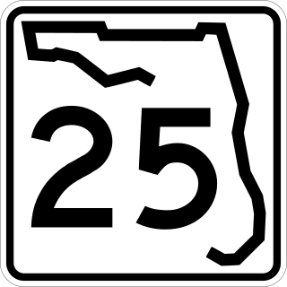
State Road 25 is a state highway in the U.S. state of Florida. It is mainly signed as U.S. Highways:

<span class="mw-page-title-main">Florida State Road 13</span> Highway in Florida

State Road 13 (SR 13) is a 28.25-mile-long (45.46 km) state highway in the U.S. state of Florida, running north from SR 16 near Green Cove Springs, through Switzerland to Jacksonville on the east shore of the St. Johns River.

<span class="mw-page-title-main">Florida State Road 37</span> State highway in Manatee, Hillsborough, and Polk counties in Florida, United States

State Road 37 (SR 37) is a state highway in Manatee and Polk counties in Florida, United States, that also passes through the very extreme southeast corner of Hillsborough. It connects Florida State Road 62 (SR 62) in Duette, Florida with Florida State Road 35 / Florida State Road 600 in Lakeland. It is signed as Church Avenue in Mulberry and South Florida Avenue in Lakeland.

<span class="mw-page-title-main">U.S. Route 23 in Florida</span> Highway in Florida

U.S. Highway 23 (US 23) is a United States Numbered Highway that runs from Jacksonville, Florida to Mackinaw City, Michigan. In the U.S. state of Florida, US 23 is concurrent with US 1 south of Alma, Georgia, except in Downtown Jacksonville. US 23 is also concurrent with US 301 between Homeland, Georgia and Callahan. In the Jacksonville area, US 23 is the unsigned State Road 139 (SR 139), which also continues east from the south end of US 23 along SR 10A to SR 115 near the Mathews Bridge.

<span class="mw-page-title-main">Florida State Road 97</span> Highway in Florida

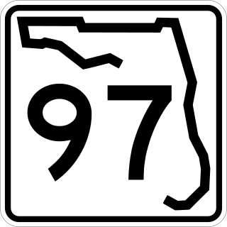
State Road 97 is a south-north two-lane highway entirely in Escambia County, Florida. It runs from County Road 95A, just southeast of U.S. Highway 29 in Molino, to the Alabama state line near Atmore, where it becomes State Route 21. The road runs through the community of Walnut Hill and serves primarily to connect Pensacola to the northwest Escambia County and Atmore areas. In combination with SR 21, the road also provides a connection to Interstate 65.

<span class="mw-page-title-main">Gateway Expressway</span> Tolled highway in Florida

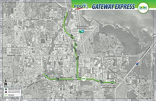
The Gateway Expressway is a toll road under construction in Pinellas County, Florida that is expected to be completed in late 2022 at a cost of $598 million. The project consists of two branches: an elevated highway to be designated State Road 690 above 118th Avenue North between Interstate 275 (I-275) and U.S. Highway 19 and a raised highway in the median of SR 686 from 118th Avenue North to the Bayside Bridge. Construction was approved in February 2014 and began in November 2017.

References

  1. FDOT straight line diagrams, accessed January 2014