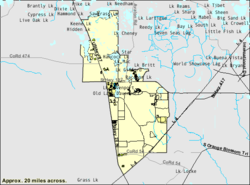
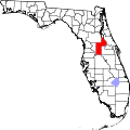
Four Corners, Florida

Last updated

Four Corners, Florida
Lake County Florida Incorporated and Unincorporated areas Citrus Ridge Highlighted.svg
Location in Lake County and the state of Florida
Citrus Ridge.png
U.S. Census Bureau map showing CDP boundaries
Coordinates: 28°19′59″N81°38′50″W / 28.33306°N 81.64722°W / 28.33306; -81.64722
Country United States
State Florida
Counties Lake, Polk, Osceola, Orange
Area
[1]
  Total50.96 sq mi (131.99 km2)
  Land47.54 sq mi (123.12 km2)
  Water3.42 sq mi (8.87 km2)
Elevation
[2]
115 ft (35 m)
Population
 (2020)
  Total56,381
  Density1,186.04/sq mi (457.93/km2)
Time zone UTC-5 (Eastern (EST))
  Summer (DST) UTC-4 (EDT)
ZIP codes
33897, 34714, 34747, 34787
FIPS code 12-24581 [3]
GNIS feature ID2402506 [2]

Four Corners, is an unincorporated suburban area and census-designated place (CDP) in the U.S. state of Florida, located in the region around the intersection of Lake, Orange, Osceola, and Polk counties. Its population was 56,381 at the 2020 census, up from 26,116 at the 2010 census.

Contents

The Lake, Orange, and Osceola County portions of Four Corners are part of the Orlando–Kissimmee–Sanford, Florida Metropolitan Statistical Area, while the Polk County portion is part of the Lakeland Winter Haven Metropolitan Statistical Area.

Splendid China was a theme park in Four Corners. It opened in 1993, closed on December 31, 2003, and sat abandoned for 10 years after that. Splendid China Florida cost $100 million to build. It was a 75-acre (30 ha) miniature park with more than 60 replicas at one-tenth scale.[ citation needed ] Margaritaville Resort opened[ when? ] on the former Splendid China site, with resort homes, condos and timeshares in a Jimmy Buffett-themed setting. In the summer of 2019, the Sunset Walk restaurants and shops opened next to the Margaritaville Resort. Radio Margaritaville broadcasts from the Margaritaville Resort.

Geography

Four Corners is in referenced to the four-way intersection of the Lake, Orange, Osceola, and Polk County borders near the center of the CDP, hence the name "Four Corners". Neighboring communities are Horizon West and Bay Lake to the northeast, Celebration to the east, and Loughman to the southeast. It is 25 miles (40 km) southwest of Orlando and 37 miles (60 km) northeast of Lakeland.

According to the United States Census Bureau, the Four Corners CDP has a total area of 50.8 square miles (131.7 km2), of which 47.4 square miles (122.8 km2) are land and 3.4 square miles (8.9 km2), or 6.74%, are water. [3]

The Census-drawn boundaries for the area include Interstate 4 along part of the southern border and U.S. Route 27 along part of the western border. The Western Beltway (Florida State Road 429) travels through the eastern portion of the CDP. Areas outside the CDP that are sometimes considered part of Four Corners include north along US 27 to Lake Louisa State Park (4 miles north of US 192), south along US 27 to Heart of Florida Hospital (3 miles south of I-4), west to SR 33, and east to Walt Disney World Resort and Celebration.[ citation needed ] Four Corners is the only community in Florida to be located in four counties.[ citation needed ]

The community has the most lightning strikes per area than anywhere else in the United States. [4]

Demographics

Historical population
CensusPop.Note
2000 12,015
2010 26,116117.4%
2020 56,381115.9%
U.S. Decennial Census [5]
Four Corners racial composition
(Hispanics excluded from racial categories)
(NH = Non-Hispanic)
RacePop 2010 [6] Pop 2020 [7] % 2010% 2020
White (NH)15,16727,46558.08%48.71%
Black or African American (NH)1,7694,5126.77%8.00%
Native American or Alaska Native (NH)811180.31%0.21%
Asian (NH)6211,3692.38%2.43%
Pacific Islander or Native Hawaiian (NH)29320.11%0.06%
Some other race (NH)1014890.39%0.87%
Two or more races/Multiracial (NH)4892,6211.87%4.65%
Hispanic or Latino (any race)7,85919,77530.09%35.07%
Total26,11656,381100.00%100.00%

As of the 2020 United States census, there were 56,381 people, 15,955 households, and 10,559 families residing in the CDP. [8]

For the period 2013-2017, the estimated median annual income for a household in the CDP was $53,750, and the median income for a family was $57,173. Male full-time workers had a median income of $36,079 versus $30,070 for females. The per capita income for the CDP was $23,653. About 12.8% of families and 15.9% of the population were below the poverty line, including 27.4% of those under age 18 and 6.7% of those age 65 or over. [9]

As of the 2010 United States census, there were 26,116 people, 9,673 households, and 6,836 families residing in the CDP. [10]

Of the 9,673 households in 2010, 33.6% had children under the age of 18 living with them, 52.0% were headed by married couples living together, 13.3% had a female householder with no husband present, and 29.6% were non-families. 21.0% of all households were made up of individuals, and 4.9% were someone living alone who was 65 years of age or older. The average household size was 2.64, and the average family size was 3.05. [11]

In 2010, 23.7% of the CDP population were under the age of 18, 8.6% were from 18 to 24, 30.1% were from 25 to 44, 25.0% were from 45 to 64, and 12.7% were age 65 or older. The median age was 36.7 years. For every 100 females, there were 94.6 males. For every 100 females age 18 and over, there were 91.8 males. [11]

Government and infrastructure

Osceola County Fire Rescue Station 71 Osceola County Fire Rescue Station 71.jpg
Osceola County Fire Rescue Station 71

Osceola County Fire Rescue operates Station 71 in Four Corners. Polk County Fire Rescue operates Station 42 (on U.S. 27 just south of U.S.192) and 33 (on Ronald Reagan Blvd just east of U.S. 27) in Four Corners. Lake County Fire Rescue operates Station 112 in Four Corners. Orange County Fire Rescue operates Station 32 in Four Corners. [12]

Education

The CDP is served by four different school districts: [13]

Transportation

The Four Corners area is served by U.S. Routes 27 and 192, which intersect one mile west of the quadripoint.

The area is served by two Lynx bus routes, which terminate at Legacy Boulevard on US 192. [18] Link 55 travels east on US 192, and link 427 travels south on US 27.

Related Research Articles

<span class="mw-page-title-main">Celebration, Florida</span> CDP in Florida, United States

Celebration is a master-planned community (MPC) and census-designated place (CDP) in Osceola County, Florida, United States. A suburb of Orlando, Celebration is located near Walt Disney World Resort and was originally developed by The Walt Disney Company. Its population was recorded as 11,178 in the 2020 census.

<span class="mw-page-title-main">Lake County, Florida</span> County in Florida, United States

Lake County is a county in the central portion of the U.S. state of Florida. As of the 2020 census, the population was 383,956. Its county seat is Tavares, and its largest city is Clermont. Lake County is included in the Orlando–Kissimmee–Sanford Metropolitan Statistical Area.

<span class="mw-page-title-main">Osceola County, Florida</span> County in Florida, United States

Osceola County is a county located in the central portion of the U.S. state of Florida. As of the 2020 census, the population was 388,656. Its county seat is Kissimmee. Osceola County is included in the Orlando–Kissimmee–Sanford, Fla. Metropolitan Statistical Area.

<span class="mw-page-title-main">Sumter County, Florida</span> County in Florida, United States

Sumter County is a county located in the central portion of the U.S. state of Florida. As of the 2020 census, the population is 129,752. It has the oldest median age of any US county and the highest percentage of residents aged 65 and older—at 55.6% in 2014-2018. Its county seat is Bushnell, and the largest community is The Villages.

<span class="mw-page-title-main">Lakeside, Florida</span> Census-designated place in Florida

Lakeside is an unincorporated area and census-designated place in Clay County, Florida, United States. It is part of the greater Orange Park area. The population was 31,275 at the 2020 census.

<span class="mw-page-title-main">Mount Plymouth, Florida</span> Census-designated place in Florida

Mount Plymouth is an unincorporated community and census-designated place (CDP) in Lake County, Florida, United States. As of the 2010 census, the CDP population was 4,011, up from 2,814 in 2000. It is part of the Orlando–Kissimmee Metropolitan Statistical Area.

<span class="mw-page-title-main">Country Club, Florida</span> Census-designated place in Florida

Country Club is a census-designated place and a suburban unincorporated community located in northwest Miami-Dade County, Florida, United States. It is located in the Miami metropolitan area of South Florida. The CDP is named after the Country Club of Miami, which was established in 1961 in what was then an unpopulated and undeveloped section of the county. The population was 49,967 at the 2020 census, up from 3,408 in 1990.

<span class="mw-page-title-main">Azalea Park, Florida</span> Census-designated place in Florida, United States

Azalea Park is a census-designated place (CDP) and an unincorporated area in Orange County, Florida, United States. The population was 12,556 at the 2010 census. It is part of the Orlando–Kissimmee–Sanford, Florida Metropolitan Statistical Area.

<span class="mw-page-title-main">Bay Hill, Florida</span> Census-designated place in Florida, United States

Bay Hill is a census-designated place (CDP) in Orange County, Florida, United States. The population was 4,884 at the 2010 census. It is part of the Orlando–Kissimmee Metropolitan Statistical Area. The Bay Hill area is generally located on either side of Apopka-Vineland Road in southwest Orange County, north of Lake Buena Vista and south of Windermere.

<span class="mw-page-title-main">Bay Lake, Florida</span> City in Florida, United States

Bay Lake is a city in Orange County, Florida, United States. The population was 29 at the 2020 census. It is named after a lake that lies east of the Magic Kingdom. All four of the Walt Disney World Resort theme parks, and one of Walt Disney World's two water parks, are in Bay Lake, though all Disney parks in the region have mailing addresses in nearby Lake Buena Vista.

<span class="mw-page-title-main">Dr. Phillips, Florida</span> Census-designated place in Florida, United States

Dr. Phillips is a census-designated place and an unincorporated area in Orange County, Florida, United States. It is a suburb of Orlando and is part of the Orlando–Kissimmee–Sanford, Florida Metropolitan Statistical Area. The population was 12,328 at the 2020 census.

<span class="mw-page-title-main">Meadow Woods, Florida</span> Census-designated place in Florida, United States

Meadow Woods is a census-designated place (CDP) and an unincorporated suburban development area located in southern Orange County, Florida, United States, between Orlando International Airport and Kissimmee. It is part of the Orlando–Kissimmee–Sanford, Florida Metropolitan Statistical Area. As of 2020, the population was 43,790.

<span class="mw-page-title-main">Winter Garden, Florida</span> City in Florida, United States

Winter Garden is a city in western Orange County, Florida, United States. Located 14 miles (23 km) west of Downtown Orlando, it is part of the Orlando metropolitan area. The population was 46,964 as of the 2020 census.

<span class="mw-page-title-main">Kissimmee, Florida</span> City in Florida, United States

Kissimmee is the largest city and county seat of Osceola County, Florida, United States. As of the 2020 census, the population was 79,226. It is a Principal City of the Orlando-Kissimmee-Sanford, Florida, Metropolitan Statistical Area, which had a 2020 population of 2,673,376. The Census Bureau defines an urban area with Kissimmee as the principal city, which is separated from the Orlando urban area. The Kissimmee–St. Cloud, FL urban area had a 2020 population of 418,404, making it the 100th largest in the United States.

<span class="mw-page-title-main">Inwood, Florida</span> Census-designated place in Florida, United States

Inwood is a census-designated place (CDP) in Polk County, Florida, United States. The population was 6,925 at the time of the 2000 United States Census. It is part of the Lakeland–Winter Haven Metropolitan Statistical Area.

<span class="mw-page-title-main">Loughman, Florida</span> Census-designated place in Florida, United States

Loughman (LOFF-mǝn) is a census-designated place (CDP) in the northeast corner of Polk County, Florida, United States, near the Osceola county line. The population was 1,385 at the 2000 census. It is part of the Lakeland–Winter Haven Metropolitan Statistical Area. This area has grown rapidly since 2000 due, in large part, to its proximity to Walt Disney World and the Orlando, Florida area.

Buena Ventura Lakes, more commonly known as BVL, is a census-designated place (CDP) in northern Osceola County, Florida, United States, near Kissimmee. Its population was 26,079 at the 2010 census. It is part of the Orlando–Kissimmee–Sanford, Florida Metropolitan Statistical Area. The community is served by the Osceola Library System.

Poinciana is a settlement and census-designated place (CDP) in Osceola and Polk counties in the U.S. state of Florida. It is part of the Greater Orlando area. As of the 2020 census, the CDP had a population of 69,309.

<span class="mw-page-title-main">Alafaya, Florida</span> Census-designated place in Florida, United States

Alafaya is a census-designated place and unincorporated area in Orange County, Florida, United States. The population was 92,452 at the 2020 US census. It is part of the Orlando–Kissimmee–Sanford, Florida Metropolitan Statistical Area. It is most known for being near the University of Central Florida, Avalon Park and Waterford Lakes.

Horizon West is a census-designated place (CDP) and unincorporated area in Orange County, Florida, United States. It is part of the Orlando–Kissimmee–Sanford, Florida Metropolitan Statistical Area. The population was 58,101 at the 2020 census.

References

    1. "2020 U.S. Gazetteer Files". United States Census Bureau. Retrieved October 31, 2021.
    2. 1 2 U.S. Geological Survey Geographic Names Information System: Four Corners, Florida
    3. 1 2 "U.S. Gazetteer Files: 2019: Places: Florida". U.S. Census Bureau Geography Division. Retrieved November 13, 2019.
    4. Barry, Rebecca; Martichoux, Alix (January 9, 2023). "These US cities are 'lightning capitals,' report says". The Hill. Retrieved December 25, 2023.
    5. "Census of Population and Housing". Census.gov. Retrieved June 4, 2016.
    6. "P2 HISPANIC OR LATINO, AND NOT HISPANIC OR LATINO BY RACE - 2010: DEC Redistricting Data (PL 94-171) - Four Corners CDP, Florida". United States Census Bureau .
    7. "P2 HISPANIC OR LATINO, AND NOT HISPANIC OR LATINO BY RACE - 2020: DEC Redistricting Data (PL 94-171) - Four Corners CDP, Florida". United States Census Bureau .
    8. "S1101 HOUSEHOLDS AND FAMILIES - 2020: Four Corners CDP, Florida". United States Census Bureau .
    9. "Four Corners CDP, Florida: ACS 5-Year Estimates Subject Tables (2017)". data.census.gov. Retrieved November 13, 2019.
    10. "S1101 HOUSEHOLDS AND FAMILIES - 2010: Four Corners CDP, Florida". United States Census Bureau .
    11. 1 2 "Profile of General Population and Housing Characteristics: 2010 Census Summary File 1 (DP-1), Four Corners CDP, Florida". American FactFinder. U.S. Census Bureau. Archived from the original on February 13, 2020. Retrieved November 13, 2019.
    12. "Station 71." Osceola County. Retrieved on April 19, 2017. " 8706 W. Irlo Bronson Memorial Hwy. Kissimmee, FL 34747"
    13. "2010 CENSUS - CENSUS BLOCK MAP (INDEX): Four Corners CDP, FL." U.S. Census Bureau. Retrieved on April 22, 2017. Map pages: 1, 2, 3, 4, 5, 6, 7, 8, 9, 10, A01, B01, C01, D01.
    14. "Keene's Crossing Elementary School Zone." Orange County Public Schools Office of Pupil Assignment. February 20, 2015. Retrieved on April 21, 2017.
    15. "Bridgewater Middle School Zone Archived 2017-04-22 at the Wayback Machine ." Orange County Public Schools Office of Planning & Governmental Relations and Student Enrollment. April 28, 2016. Retrieved on April 22, 2017.
    16. "Windermere High School Attendance Zone map, effective 08/2017" (PDF). OCPS Department of Student Enrollment. Archived from the original (PDF) on March 22, 2017.
    17. "Rezoning Spring 2016 Archived 2017-02-04 at the Wayback Machine ." Orange County Public Schools. Retrieved on April 22, 2017.
    18. "LYNX website". Archived from the original on January 11, 2014. Retrieved January 11, 2014.