Babson Park, Florida

Last updated
Babson Park, Florida
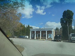
USPS Babson Park, FL - 33827.jpg
The Babson Park Post Office as seen from the entrance on SR 17.
Polk County Florida Incorporated and Unincorporated areas Babson Park Highlighted 1202900.svg
Location in Polk County, Florida
Coordinates: 27°49′49″N81°31′42″W / 27.83028°N 81.52833°W / 27.83028; -81.52833
Country United States
State Florida
County Polk
Area
[1]
  Total1.52 sq mi (3.95 km2)
  Land1.52 sq mi (3.95 km2)
  Water0.00 sq mi (0.00 km2)
Elevation
144 ft (44 m)
Population
 (2020)
  Total1,330
  Density872.70/sq mi (336.98/km2)
Time zone UTC-5 (Eastern (EST))
  Summer (DST) UTC-4 (EDT)
ZIP code
33827
Area code 863
FIPS code 12-02900 [2]
GNIS feature ID0278019 [3]

Babson Park is a census-designated place (CDP) in Polk County, Florida, United States. The population was 1,182 at the 2000 census. It is also the home of Webber International University.

Contents

Babson Park is part of the Lakeland Winter Haven Metropolitan Statistical Area, situated roughly halfway between Tampa and Orlando.

Geography

Babson Park is located at 27°49′49″N81°31′42″W / 27.830416°N 81.528250°W / 27.830416; -81.528250 . [4]

According to the United States Census Bureau, the CDP has a total area of 3.9 km2 (1.5 mi2), all land.

Demographics

Historical population
CensusPop.Note
2020 1,330
U.S. Decennial Census [5]

As of the census [2] of 2000, there were 1,182 people, 367 households, and 277 families residing in the CDP. The population density was 306.3/km2 (791.4/mi2). There were 442 housing units at an average density of 114.5/km2 (295.9/mi2). The racial makeup of the CDP was 77.92% White, 16.92% African American, 1.44% Asian, 2.88% from other races, and 0.85% from two or more races. Hispanic or Latino of any race were 7.11% of the population.

There were 367 households, out of which 41.4% had children under the age of 18 living with them, 56.9% were married couples living together, 12.8% had a female householder with no husband present, and 24.3% were non-families. 17.4% of all households were made up of individuals, and 6.8% had someone living alone who was 65 years of age or older. The average household size was 2.81 and the average family size was 3.22.

In the CDP, the population was spread out, with 26.7% under the age of 18, 18.4% from 18 to 24, 26.1% from 25 to 44, 18.0% from 45 to 64, and 10.8% who were 65 years of age or older. The median age was 30 years. For every 100 females, there were 104.1 males. For every 100 females age 18 and over, there were 100.9 males.

The median income for a household in the CDP was $28,487, and the median income for a family was $34,444. Males had a median income of $30,625 versus $18,875 for females. The per capita income for the CDP was $11,912. About 9.2% of families and 10.3% of the population were below the poverty line, including 8.0% of those under age 18 and 15.9% of those age 65 or over.

Education

Despite its small size, Babson Park is home to Webber International University and just a half-mile from Warner University. Babson Park is also home to Dale R. Fair Babson Park Elementary.

Climate

The climate in this area is characterized by hot, humid summers and generally mild to cool winters. According to the Köppen Climate Classification system, Babson Park has a humid subtropical climate, abbreviated "Cfa" on climate maps. [6]

Related Research Articles

<span class="mw-page-title-main">June Park, Florida</span> Census-designated place in Florida

June Park is a census-designated place (CDP) in Brevard County, Florida. The population was 4,094 at the 2010 United States Census. It is part of the Palm Bay–Melbourne–Titusville Metropolitan Statistical Area.

<span class="mw-page-title-main">Goodland, Florida</span> Census-designated place in Florida

Goodland is a census-designated place (CDP) in Collier County, Florida, United States. The population was 267 at the 2010 census. It is part of the Naples–Marco Island Metropolitan Statistical Area. Located on the southeast portion of Marco Island, it is the closest community to Cape Romano, the southern tip of a nearby island that was the official site of the Florida landfall of Hurricane Wilma.

<span class="mw-page-title-main">Plantation Island, Florida</span> Census-designated place in Florida

Plantation Island is a census-designated place (CDP) in Collier County, Florida, United States. The population was 163 at the 2010 census. It is part of the Naples–Marco Island Metropolitan Statistical Area.

<span class="mw-page-title-main">Winter Beach, Florida</span> Census-designated place in Florida, United States

Winter Beach is a census-designated place (CDP) in Indian River County, Florida, United States. The population was 2,067 at the 2010 census, up from 965 at the 2000 census. It is part of the Sebastian–Vero Beach Metropolitan Statistical Area.

<span class="mw-page-title-main">Page Park, Florida</span> Census-designated place in Florida, United States

Page Park is a census-designated place (CDP) in Lee County, Florida, United States. The population was 747 at the 2020 census. It is part of the Cape Coral-Fort Myers, Florida Metropolitan Statistical Area.

<span class="mw-page-title-main">Woodville, Florida</span> CDP in Florida, United States

Woodville is a census-designated place in Leon County, Florida, United States, just south of Tallahassee, Florida. The population was 2,978 at the 2010 census. It is part of the Tallahassee, Florida Metropolitan Statistical Area. The American Civil War Battle of Natural Bridge, in March 1865, occurred in what is now Woodville, at the Natural Bridge. This is where the St. Marks River drops into a sinkhole, the Natural Bridge Sink and flows underground, reemerging .25 miles (0.40 km) later.

<span class="mw-page-title-main">Gotha, Florida</span> Census-designated place in Florida, United States

Gotha is a census-designated place (CDP) in Orange County, Florida, United States. Gotha is located between Ocoee and Windermere and had a population of 1,915 at the 2010 census, up from 731 as recorded by the 2000 census. It is part of the Orlando–Kissimmee Metropolitan Statistical Area. It is the resting place of the famous painter Bob Ross.

<span class="mw-page-title-main">Southchase, Florida</span> Census-designated place in Florida, United States

Southchase is a census-designated place and an unincorporated area in Orange County, Florida, United States. The population was 15,921 at the 2010 census. It is part of the Orlando–Kissimmee–Sanford, Florida Metropolitan Statistical Area.

<span class="mw-page-title-main">Hillcrest Heights, Florida</span> Town in the state of Florida, United States

Hillcrest Heights is a town in Polk County, Florida, United States. The population was 254 at the 2010 census. As of 2018, the population recorded by the U.S. Census Bureau is 294. It is part of the Lakeland–Winter Haven Metropolitan Statistical Area.

<span class="mw-page-title-main">Ferndale, Maryland</span> Census-designated place in Maryland, United States

Ferndale is a census-designated place (CDP) in Anne Arundel County, Maryland, United States. At the 2010 census, the population was 16,746.

<span class="mw-page-title-main">Lochearn, Maryland</span> Census-designated place in Maryland, United States

Lochearn is an unincorporated community and census-designated place in Baltimore County, Maryland, United States, located immediately to the west of the City of Baltimore. Per the 2020 census, the population was 25,511.

<span class="mw-page-title-main">Perryman, Maryland</span> Census-designated place in Maryland, United States

Perryman is an unincorporated community and census-designated place (CDP) in Harford County, Maryland, United States. The population was 2,342 at the 2010 census.

<span class="mw-page-title-main">Shark River Hills, New Jersey</span> Census-designated place in New Jersey, United States

Shark River Hills is an unincorporated community and census-designated place (CDP) within Neptune Township, in Monmouth County, New Jersey, United States. As of the 2010 United States Census, the CDP's population was 3,697.

<span class="mw-page-title-main">Walton Park, New York</span> CDP in New York, United States

Walton Park is a census-designated place (CDP) in Orange County, New York, United States. As of the 2020 census, the CDP had a total population of 3,907. Walton Park is on the town line separating the towns of Chester and Monroe. Street addresses within Walton Park are usually assigned to Monroe, not Chester.

<span class="mw-page-title-main">Heidelberg, Texas</span> Census-designated place in Texas

Heidelberg is a census-designated place (CDP) in Hidalgo County, Texas. The population was 1,725 at the 2010 United States Census. It is part of the McAllen–Edinburg–Mission Metropolitan Statistical Area.

<span class="mw-page-title-main">Lolita, Texas</span> CDP in Texas

Lolita is a census-designated place (CDP) in Jackson County, Texas, United States. The population was 555 at the 2010 census.

<span class="mw-page-title-main">Knippa, Texas</span> Census-designated place in Texas, United States

Knippa is a census-designated place (CDP) in Uvalde County, Texas, United States. The population was 689 at the 2010 census.

<span class="mw-page-title-main">South Barre, Vermont</span> CDP in Vermont, United States

South Barre is a census-designated place (CDP) in the town of Barre in Washington County, Vermont, United States. The population was 1,242 at the 2000 census.

<span class="mw-page-title-main">Jolivue, Virginia</span> Census-designated place in Virginia, United States

Jolivue is a census-designated place (CDP) in Augusta County, Virginia, United States. The population was 1,129 at the 2010 census. It is part of the Staunton–Waynesboro Micropolitan Statistical Area.

<span class="mw-page-title-main">Boaz, West Virginia</span> CDP in West Virginia, United States

Boaz is a census-designated place (CDP) in Wood County, West Virginia, United States. It is part of the Parkersburg-Marietta-Vienna, WV-OH Metropolitan Statistical Area. As of the 2020 census, the CDP population was 1,321.

References

  1. "2020 U.S. Gazetteer Files". United States Census Bureau. Retrieved October 31, 2021.
  2. 1 2 "U.S. Census website". United States Census Bureau . Retrieved 2008-01-31.
  3. "US Board on Geographic Names". United States Geological Survey. 2007-10-25. Retrieved 2008-01-31.
  4. "US Gazetteer files: 2010, 2000, and 1990". United States Census Bureau. 2011-02-12. Retrieved 2011-04-23.
  5. "Census of Population and Housing". Census.gov. Retrieved June 4, 2016.
  6. Climate Summary for Babson Park, Florida