Apopka | |
---|---|
![]() Apopka City Hall in April 2007 | |
Nickname: Indoor Foliage Capital of the World | |
![]() Location of Apopka in Orange County, Florida. | |
Coordinates: 28°42′06″N81°31′54″W / 28.70167°N 81.53167°W [1] [2] | |
Country | United States |
State | Florida |
County | Orange |
Incorporated (Town of Apopka City) | 1882 [3] |
Incorporated (City of Apopka) | 1919 [4] |
Government | |
• Type | Mayor–Commission |
• Mayor | Bryan Nelson (R) |
• Commissioners | Alexander Smith, Diane Velazquez, Kyle Becker, and Nick Nesta |
• City Clerk | Susan M. Bone |
Area | |
• Total | 35.97 sq mi (93.17 km2) |
• Land | 34.59 sq mi (89.60 km2) |
• Water | 1.38 sq mi (3.58 km2) 4.07% |
Elevation | 82 ft (25 m) |
Population (2020) | |
• Total | 54,873 |
• Density | 1,586.25/sq mi (612.44/km2) |
Demonym | Apopkan |
Time zone | UTC−5 (EST) |
• Summer (DST) | UTC−4 (EDT) |
ZIP codes | 32703, 32704, 32712 |
Area codes | 321, 407, 689 |
FIPS code | 12-01700 [6] |
GNIS feature ID | 2403103 [1] |
Website | www |
Apopka is a city in Orange County, Florida. The city's population was 54,873 at the 2020 census. It is part of the Orlando–Kissimmee–Sanford Metropolitan Statistical Area. Apopka comes from Seminole word Ahapopka for "potato-eating place". [7]
Apopka is referred to as the "Indoor Foliage Capital of the World" [8] due to the many greenhouse nurseries there. [9]
The earliest known inhabitants of the Apopka area were the Acuera people, members of the Timucua confederation. They had disappeared by 1730, probably decimated by diseases transmitted through Florida by Spanish colonists.
The Acuera were succeeded by refugees from Alabama and Georgia, who formed the new Seminole Indian tribe. They called the area Ahapopka. Aha, meaning "Potato," and papka, meaning "eating place". By the 1830s, this settlement numbered about 200, and was the birthplace of the chief Coacoochee (known in English as "Wild Cat").
At the conclusion of the Second Seminole War, the U.S. Congress passed the Armed Occupation Act of 1842, forcing surviving natives at Ahapopka to abandon their village and seek refuge deeper in the wilderness of the Florida peninsula.
The early American settlers built a major trading center on the foundations of the earlier Indian settlement. Their population was large enough by 1857 to support the establishment of a Masonic lodge. In 1859 the lodge erected a permanent meeting place at what is now the intersection of Main Street (U.S. Highway 441) and Alabama Avenue.
The settlers in the vicinity of "The Lodge" were largely isolated during the Civil War, but the area rebounded once peace was re-established, and a population boom followed the construction of railroad lines through the region.
In 1869, the Apopka Post Office opened. [10]
In 1882, the one mile in each direction of "The Lodge" or "Fudge Hall" was officially incorporated under the name "Town of Apopka City". [3] In the 1890s, the town was contracted in size more than once due to difficult times. [11]
In 1905, the Apopka City Council authorized incorporation of the Apopka Water, Light, and Ice Company. Councilman A.M. Starbird was appointed its manager, but it was not until voters approved a $9,000 bond in 1914 that he was able to contract with International Harvester Corporation to construct a power plant, so electricity was not available in the city until February 10, 1915. This independent utility company was one of many that were acquired by the Florida Public Service Corporation in the 1920s. They continued to manage the city's utility needs until the 1940s, when they sold off its ice plants to the Atlantic Company, its electric service to Florida Power Corporation, and its water services to Florida Utilities.
Between 1937 and 1968 a town ordinance forbade Black residents from living north of the railroad tracks. [12]
Five buildings in Apopka have been placed on the U.S. National Register of Historic Places through the Apopka Historical Society housed in the Museum of the Apopkans.
Year Built | Building Name | Address | Image |
---|---|---|---|
1918 | Apopka Seaboard Air Line Railway Depot | 36 E Station St | |
1886 | Waite-Davis House | 5 S Central Ave | ![]() |
1887 | Mitchell-Tibbetts House | 21 E Orange St | |
1920 | Ryan & Company Lumber Yard | 215 E Fifth St | |
1932 | Carroll Building (Apopka, Florida) | 407-409 S Park Ave |
Apopka is known for having one of the longest-serving mayors in the United States. John H. Land, first elected in 1949, served for over 61 years (with a short three-year gap), making him the longest-serving mayor in Florida and longest-serving full-time mayor in the United States through 2014. [13] Apopka is served by the Apopka Police Department within city limits and the Orange County Sheriff's Department for unincorporated Apopka.
On April 8, 2014, Apopka City Commissioner Joe Kilsheimer won the election [14] to succeed John H. Land as mayor. Kilsheimer was sworn in on April 22, 2014. [15] The 2018 primary for mayor resulted in a landslide win for Bryan Nelson with 63.40% (4,103) of the vote to Kilsheimer's 36.6% (2,369). [16] No runoff was required.
This section may need to be rewritten to comply with Wikipedia's quality standards.(September 2024) |
Mayor | First Year | Term of Years | Total Years | Mayor | First Year | End Year | Term of Years | Total Years |
---|---|---|---|---|---|---|---|---|
James Daniel Fudge | 1882 | 3 | John Jewell | 1926 Jan | 1930 Dec | 5 | ||
Jessse J. Combs | 1885 | 1 | Edward J. Ryan | 1931 Jan | 1934 Dec | 3 | ||
Page McKinney | 1886 | 2 | Gillen McClure | 1935 Jan | 1937 Dec | 3 | ||
Dr. Horatio S. Brewer | 1888 | 5 | Mark V. Ryan | 1938 Jan | 1940 Dec | 3 | ||
R. C. Waters | 1893 | 2 | Leslie P. Waite | 1941 Jan | 1946 Dec | 6 | ||
E. A. Jackson | 1895 | 1 | Dr. Charles Henry Damsel | 1947 Jan | 1949 Dec | 3 | ||
Andrew Jackson Lovell | 1896 | 9 | * | John Horting Land | 1950 Jan | 1967 Dec | 18 | * |
Joseph D Mitchill | 1905 | 7 | * | Leonard Hurst | 1968 Jan | 1970 Dec | 3 | |
Adelbert M. Starbird | 1912 | 1 | John Horting Land | 1971 Jan | 2014 Mar | 43.25 | 61.25 | |
Andrew Jackson Lovell | 1913 | 1 | 10 | Joe Kilsheimer | 2014 Apr | 2018 | 4 | |
Walter R. McLeod | 1914 | 1 | Bryan Nelson | 2018 Apr 24 | 2026 | 8 | ||
Frank Davis | 1915 | 1 | ||||||
Walter Newell | 1916 | 2 | * | |||||
Thomas B. Tower | 1918 | 1 | ||||||
Walter P. Newell | 1919 | 1 | 3 | |||||
Joseph D Mitchill | 1920 | 3 | 10 | |||||
Edward Barker Morrey | 1923 | 3 |
Apopka is a fast-growing city and is expanding in all directions. Most notable are the new stores to the north of the city on US 441 in the location of the previous Dunn Citrus grove (the stretch of 441 which runs through the city is named after Fred N. Dunn). Due to the fast-paced growth of the city, a new hospital, AdventHealth Apopka, was opened in 2017. [21]
The John Land Apopka Expressway (Toll 414) opened on May 15, 2009, relieving some of US 441's traffic, taking the route from what is now the US 441 junction with SR 429, and then passing south of the city to rejoin US 441 at its junction with Maitland Boulevard South of the city. [22]
Expansion of the expressway, including an extension of Toll 414, known as Wekiva Parkway, created a junction at US 441 and Plymouth Sorrento Road. Master plans take the Wekiva Parkway extension further north and then east connecting to Interstate 4 at Sanford. The expansion is scheduled to be completed by 2023. [23] It will then be the shortest route from I-4 to the Disney attractions. [24]
The approximate coordinates for the City of Apopka is located at 28°42′06″N81°31′54″W / 28.70167°N 81.53167°W .
Apopka is about 16 miles northwest of Downtown Orlando.
According to the United States Census Bureau, the city has a total area of 32.6 square miles (84.4 km2). 31.2 square miles (80.9 km2) of it is land and 1.4 square miles (3.5 km2) of it (4.15%) is water. [25]
The climate in this area is characterized by hot, humid summers and generally mild winters. According to the Köppen climate classification, the City of Apopka has a humid subtropical climate zone (Cfa).
Climate data for Plymouth 3N, 2002–2015 normals, extremes 2002–present | |||||||||||||
---|---|---|---|---|---|---|---|---|---|---|---|---|---|
Month | Jan | Feb | Mar | Apr | May | Jun | Jul | Aug | Sep | Oct | Nov | Dec | Year |
Record high °F (°C) | 86 (30) | 88 (31) | 92 (33) | 96 (36) | 98 (37) | 100 (38) | 98 (37) | 99 (37) | 97 (36) | 96 (36) | 91 (33) | 87 (31) | 100 (38) |
Mean daily maximum °F (°C) | 70.2 (21.2) | 72.1 (22.3) | 78.5 (25.8) | 83.4 (28.6) | 88.6 (31.4) | 90.9 (32.7) | 92.0 (33.3) | 92.2 (33.4) | 89.8 (32.1) | 84.8 (29.3) | 76.9 (24.9) | 72.0 (22.2) | 82.6 (28.1) |
Mean daily minimum °F (°C) | 41.8 (5.4) | 44.3 (6.8) | 50.0 (10.0) | 54.8 (12.7) | 62.5 (16.9) | 69.6 (20.9) | 71.7 (22.1) | 72.3 (22.4) | 69.5 (20.8) | 60.9 (16.1) | 51.1 (10.6) | 45.4 (7.4) | 57.8 (14.3) |
Record low °F (°C) | 16 (−9) | 19 (−7) | 26 (−3) | 30 (−1) | 45 (7) | 57 (14) | 65 (18) | 63 (17) | 54 (12) | 32 (0) | 28 (−2) | 15 (−9) | 15 (−9) |
Average precipitation inches (mm) | 2.51 (64) | 2.56 (65) | 3.01 (76) | 3.02 (77) | 4.03 (102) | 7.95 (202) | 7.15 (182) | 8.36 (212) | 4.75 (121) | 2.80 (71) | 1.47 (37) | 2.71 (69) | 50.32 (1,278) |
Average rainy days (≥ 0.01 in) | 7.2 | 6.9 | 6.9 | 5.1 | 7.8 | 16.0 | 16.5 | 17.8 | 11.9 | 7.3 | 4.5 | 7.0 | 114.9 |
Source: NOAA [26] |
Census | Pop. | Note | %± |
---|---|---|---|
1890 | 490 | — | |
1900 | 218 | −55.5% | |
1910 | 410 | 88.1% | |
1920 | 798 | 94.6% | |
1930 | 1,134 | 42.1% | |
1940 | 1,312 | 15.7% | |
1950 | 2,254 | 71.8% | |
1960 | 3,578 | 58.7% | |
1970 | 4,045 | 13.1% | |
1980 | 6,019 | 48.8% | |
1990 | 13,512 | 124.5% | |
2000 | 26,642 | 97.2% | |
2010 | 41,542 | 55.9% | |
2020 | 54,873 | 32.1% | |
U.S. Decennial Census [27] |
Race | Pop 2010 [28] | Pop 2020 [29] | % 2010 | % 2020 |
---|---|---|---|---|
White (NH) | 20,553 | 20,860 | 49.48% | 38.02% |
Black or African American (NH) | 8,147 | 13,615 | 19.61% | 24.81% |
Native American or Alaska Native (NH) | 69 | 86 | 0.17% | 0.16% |
Asian (NH) | 1,309 | 1,666 | 3.15% | 3.04% |
Pacific Islander or Native Hawaiian (NH) | 19 | 28 | 0.05% | 0.05% |
Some other race (NH) | 147 | 456 | 0.35% | 0.83% |
Two or more races/Multiracial (NH) | 750 | 2,191 | 1.81% | 3.99% |
Hispanic or Latino (any race) | 10,548 | 15,971 | 25.39% | 29.11% |
Total | 41,542 | 54,873 | ||
As of the 2020 United States census, there were 54,873 people, 17,312 households, and 12,822 families residing in the city. [30]
As of the 2010 United States census, there were 41,542 people, 14,739 households, and 10,648 families residing in the city. [31]
As of the census of 2000, there were 26,642 people, 9,562 households, and 7,171 families residing in the city. The population density was 1,108.1 inhabitants per square mile (427.8/km2). There were 10,091 housing units at an average density of 419.7 per square mile (162.0/km2). The racial makeup of the city was 73.85% White, 15.56% African American, 0.42% Native American, 1.89% Asian, 0.09% Pacific Islander, 5.36% from other races, and 2.83% from two or more races. Hispanic or Latino of any race were 18.08% of the population.
In 2000, there were 9,562 households, out of which 38.2% had children under the age of 18 living with them, 55.8% were married couples living together, 14.4% had a female householder with no husband present, and 25.0% were non-families. 18.6% of all households were made up of individuals, and 5.8% had someone living alone who was 65 years of age or older. The average household size was 2.76 and the average family size was 3.13.
In 2000, in the city the population was spread out, with 28.2% under the age of 18, 8.6% from 18 to 24, 33.6% from 25 to 44, 19.5% from 45 to 64, and 10.1% who were 65 years of age or older. The median age was 33 years. For every 100 females, there were 94.0 males. For every 100 females age 18 and over, there were 90.1 males.
In 2000, the median income for a household in the city was $43,651, and the median income for a family was $49,380. Males had a median income of $32,177 versus $26,553 for females. The per capita income for the city was $19,189. About 7.1% of families and 9.5% of the population were below the poverty line, including 12.6% of those under age 18 and 9.7% of those age 65 or over.
There is only one hospital in Apopka: AdventHealth Apopka. [32]
Apopka is referenced in Zora Neale Hurston's famous novel, Their Eyes Were Watching God .
Apopka is referenced in Eddie C. Brown's autobiographical book, Beating the Odds: Eddie Brown's Investing and Life Strategies.
History of the greater Apopka and Central Florida area is detailed in William Gladden, Jr's book, The Pennings of Perrine Slim: Stories of Northwest Orange County Florida. [54] Included are 100 pictures of the area, most by Dr Phyllis Olmstead. Olmstead Publishing.
History of Apopka and Northwest Orange County, Florida by Jerrell H Shofner, (1982). Rose Printing. Apopka Historical Society.
Tales of the Big Potato by Jack Christmas (2011). New Book Publishing. Reprint Olmstead Publishing. [35]
Apopka: Images of America photos of the Apopka area, (2004). Apopka Historical Society.
Apopka takes place in and is prominently featured in Johannes Grenzfurthner's horror drama Masking Threshold that premiered at Fantastic Fest in 2021.
Apopka is referenced in "" Ernest Saves Christmas"" on Ernest's truck "Apopka Snake Ranch"
Orange County is a county located in the central part of the U.S. state of Florida. As of the 2020 census, the county had a population of 1,429,908, making it the fifth-most populous county in Florida and the 28th-most populous county in the United States. Its county seat is Orlando, which, along with it being the county's largest city, is the core of the Orlando metropolitan area, which had a population of 2.67 million in 2020.
Seminole County is a county located in the central portion of the U.S. state of Florida. As of the 2020 census, the population was 470,856, making it the 13th-most populated county in Florida. Its county seat and largest city is Sanford. Seminole County is part of the Orlando-Kissimmee-Sanford, Florida Metropolitan Statistical Area.
Clermont is a city in Lake County in central Florida, United States, about 22 miles (35 km) west of Orlando and 22 miles (35 km) southeast of Leesburg. The population was 43,021 in 2020. The city is residential in character and its economy is centered in retail trade, lodging, and tourism-oriented restaurants and bars. It is part of the Orlando–Kissimmee–Sanford Metropolitan Statistical Area.
Ocoee is a city in Orange County, Florida, United States. It is part of the Orlando–Kissimmee–Sanford, Florida Metropolitan Statistical Area. According to the 2020 US Census, the city had a population of 47,295.
Pine Hills is a census-designated place (CDP) and unincorporated subdivision in Orange County, Florida, United States, west of Orlando. Per the 2020 U.S. Census, the population was 66,111. It is a part of the Orlando–Kissimmee–Sanford, Florida Metropolitan Statistical Area.
Winter Garden is a city in western Orange County, Florida, United States. Located 14 miles (23 km) west of Downtown Orlando, it is part of the Orlando metropolitan area. The population was 46,964 as of the 2020 census.
Altamonte Springs is a suburban city in Central Florida in Seminole County, Florida, United States, which had a population of 46,231 at the 2020 United States Census. The city is in the northern suburbs of the Orlando–Kissimmee–Sanford Metropolitan Statistical Area, which the United States Census Bureau estimated had a population of 2,673,376 in 2020.
Lake Mary is a suburban city that is located in the Greater Orlando metropolitan area in Seminole County, Florida, United States, and is located in Central Florida. The population was 16,798 at the 2020 census. Home of the 2024 Little League World Series Champions.
Sanford is a city and the county seat of Seminole County, Florida. It is located in Central Florida and its population was 61,051 as of the 2020 census. It is part of the Orlando–Kissimmee–Sanford Metropolitan Statistical Area.
Wekiwa Springs is a census-designated place and an unincorporated area in Seminole County, Florida, United States. The population was 23,169 at the 2000 census. It is part of the Orlando–Kissimmee–Sanford, Florida Metropolitan Statistical Area.
The Central Florida Expressway Authority (CFX) is a highway authority responsible for construction, maintenance and operation of toll roads in five counties of Greater Orlando. It was created in 2014 to replace the Orlando–Orange County Expressway Authority (OOCEA), which only had authority in Orange County, and as of 2016 no roads outside that county have been added to the system. Other toll roads in the area are operated by Florida's Turnpike Enterprise. The Osceola County Expressway Authority, which previously operated additional toll roads in the area, merged into CFX in 2018.
State Road 451 (SR 451) is a 1.9-mile (3.1 km) controlled-access toll road connecting SR 414 and SR 429 north to US 441. The entire route is within Apopka.
State Road 429 (SR 429), also known as the Daniel Webster Western Beltway or Western Expressway south of US 441, and the Wekiva Parkway north of US 441, is a controlled-access toll road built and maintained by the Central Florida Expressway Authority (CFX), the Florida's Turnpike Enterprise, and the Florida Department of Transportation (FDOT). Its mainline extends 51.77 miles (83.32 km) from I-4 (SR 400) in Four Corners north to I-4 in Sanford. Control cities are Apopka and Tampa although the control cities for traffic at the entrances at US 441 and north are Orlando, Tampa, and Daytona Beach. SR 429 was originally planned as a western half of SR 417.
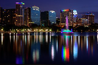
The Orlando metropolitan area is an inland metropolitan area in the central region of the U.S. state of Florida. Its principal cities are Orlando, Kissimmee, and Sanford. The U.S. Office of Management and Budget defines it as consisting of the counties of Lake, Orange, Osceola, and Seminole.
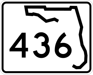
State Road 436, known as Semoran Boulevard for most of its length and Altamonte Drive in Altamonte Springs, is a north-south road in the Orlando area running from US 441 in Apopka to the Beachline Expressway near Orlando International Airport. Constructed in the late 1960s, the road passes through Seminole County, Florida and Orange County, Florida. Because of this, the common name for SR 436 is a portmanteau of the names of the two counties: "Sem" and "oran", hence "Semoran Boulevard." The common pronunciation of "Semoran" resembles that term of Cimarron.
The Central Florida Council serves Boy Scouts in Orange, Osceola, Seminole, Lake, Brevard, Volusia and Flagler Counties in Florida. Its headquarters was previously located in Orlando, Florida and is currently located in Apopka, Florida, just north of Orlando. Its primary Scout camp is Camp La-No-Che in Paisley, Florida, adjacent to the Ocala National Forest.
Apopka High School is in Apopka in northwest Orange County, Florida, United States. The school has been named a Blue Ribbon School of Excellence.
The Wekiva River is a 16.0-mile-long (25.7 km) river in Central Florida, north of Orlando in the United States. It originates in Apopka and joins the St. Johns River, the longest river in the state, in DeBary. The Wekiva River system includes the main stem joined by three main tributaries - Rock Springs Run, Blackwater Creek, and the Little Wekiva River - and about 30 contributing groundwater springs. It is designated as a Florida State Canoe Trail, an Outstanding Florida Water, and an Aquatic Preserve by the Florida Department of Environmental Protection. The Wekiva River system is also one of the two rivers in Florida federally designated as a National Wild and Scenic River for its scenery, recreation, geology, and diverse habitats.
Bryan Nelson is a Florida-based politician, serving as Mayor of Apopka since 2018. A Republican, he was a member of the Florida House of Representatives, representing the 31st District, which includes the cities of Apopka, Eustis, Mount Dora, Tavares, and Umatilla in northern Lake County and northern Orange County, since 2012. He served on the Orange County Commission for District 2 from 2014 until March 2018 when he won election for mayor of Apopka after support for the previous mayor deteriorated.
John Horting Land was Mayor of Apopka, Florida for a total of 61 years, from 1950 to 1968 and again from 1971 to 2014. He was the longest-serving mayor in the history of Florida and one of the longest-serving mayors in the United States. After having served continuously since 1971, Land was defeated in a bid for re-election by Joe Kilsheimer on April 8, 2014.
{{cite book}}
: CS1 maint: location missing publisher (link){{cite book}}
: CS1 maint: location missing publisher (link)Hometown: Apopka, FL
Glenn Hubbard was raised in Apopka, Fla...
Born: 1/31/1977 Apopka, FL
Gendreau has been openly gay since high school in Apopka, Fla.
...the incident began at the Blue Jeans Lounge in Meriweather's hometown of Apopka, Fla.
Plup, From: Apopka, Florida
When investigators finally tracked Larson to Apopka, Florida in 1999, he'd succumbed to throat cancer.