Osceola County is a county located in the central portion of the U.S. state of Florida. As of the 2020 census, the population was 388,656. Its county seat is Kissimmee. Osceola County is included in the Orlando–Kissimmee–Sanford, Fla. Metropolitan Statistical Area.

Kissimmee is the largest city and county seat of Osceola County, Florida, United States. As of the 2020 census, the population was 79,226. It is a Principal City of the Orlando-Kissimmee-Sanford, Florida, Metropolitan Statistical Area, which had a 2020 population of 2,673,376. The Census Bureau defines an urban area with Kissimmee as the principal city, which is separated from the Orlando urban area. The Kissimmee–St. Cloud, FL urban area had a 2020 population of 418,404, making it the 100th largest in the United States.

U.S. Route 192 is an east–west route of the United States Numbered Highway system in central Florida. It runs 75.04 miles (120.77 km) from U.S. Route 27 in Four Corners, Lake County, east past Walt Disney World and through Kissimmee, St. Cloud and Melbourne, to end at State Road A1A in Indialantic, one block from the Atlantic Ocean. It crosses its "parent", U.S. Route 92, in Kissimmee, for only 3,700 feet (1,100 m).
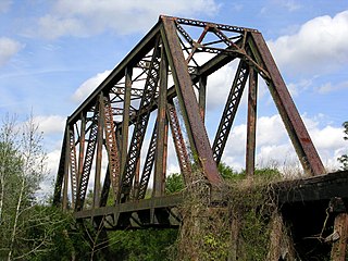
The Union Cypress Company operated a three-story double-band sawmill in Melbourne, Florida, built in 1912. The small company town of Hopkins, named after its owner George W. Hopkins, was built at the site. The company built a private railroad, often known as the Union Cypress Company Railroad, west from a connection with the Florida East Coast Railway in Melbourne across the St. Johns River to Deer Park. From there, where the logging operation was based, branch lines fanned out into the bald cypress swamps.

The Florida Trail is one of eleven National Scenic Trails in the United States, created by the National Trails System Act of 1968. It runs 1,500 miles (2,400 km), from Big Cypress National Preserve to Fort Pickens at Gulf Islands National Seashore, Pensacola Beach. Also known as the Florida National Scenic Trail, the trail provides permanent non-motorized recreation for hiking and other compatible activities within an hour's drive of most Floridians.

Deer Park is an unincorporated community in Osceola County, Florida, United States. It is located off US 192, south of the intersection with County Road 419. The community is part of the Orlando–Kissimmee Metropolitan Statistical Area. It is the location of the Kempfer Cattle ranch, Deseret Ranches of the Church of Jesus Christ of Latter-day Saints, and the Deer Park Forestry Site of the Florida Department of Agriculture and Consumer Services.
Texla is a ghost town in northern Orange County, Texas, United States, in the southeastern part of the state. It is located northwest of Orange, just west of Mauriceville. The site was originally called Bruce, after the postmaster Charles G. Bruce, who served when the office opened in 1905. The first sawmill to operate there was known as the Harrell-Votaw Lumber Company with proximity to the Orange and Northwestern Railway. The following year, the R. W. Wier Lumber Company out of Houston took over operations. The site was renamed Texla, due to its proximity to Louisiana. The owner Wier sold out to the Miller-Link Lumber Company in 1917. The peak population of the town reached an estimated 600 residents. In 1918 the mill was destroyed by fire, but was rebuilt in 1919 with a double-circular mill of the same size. Within a year, the Peavy-Moore Lumber Company of Deweyville took ownership, and operated the site until the nearby timber became exhausted. In 1929, the mill was dismantled and the site was abandoned.
From 1945 until 1977, a sawmill operated under the name Texla Lumber Company in nearby Mauriceville, according to the Texas Forestry Museum.
The School District of Osceola County, Florida is a school district serving all of Osceola County, Florida. The district has 84 schools.

U.S. Route 441 (US 441) in Florida is a north–south United States Highway. It runs 433 miles (697 km) from Miami in South Florida northwest to the Georgia state line, with the overall route continuing to Tennessee in the Rocky Top area.
Narcoossee is an unincorporated community in eastern Osceola County, Florida, United States. It is located on the east side of East Lake Tohopekaliga. The only major road which runs through Narcoossee is County Road 15, commonly referred to as Narcoossee Road, which connects to U.S. Route 192. Every spring starting in the mid 1990s, the community held the annual Battle at Narcoossee Mill in Chisolm Park, which was a Civil War reenactment. The event was discontinued in 2024 due to upcoming development at the park taking place soon.

The Florida Fish and Wildlife Conservation Commission (FWC) is a Florida government agency founded in 1999 and headquartered in Tallahassee. It manages and regulates the state's fish and wildlife resources, and enforces related laws. Officers are managers, researchers, and support personnel, and perform law enforcement in the course of their duties.
Shingle Creek is a small waterway in central Florida that is generally considered to be the northernmost headwaters of the Everglades watershed. It is named after the cypress trees that lined the bank in the late 19th century, which were used to make wood shingles. The stream and surrounding areas are protected wetlands.

Bull Creek is a rural unincorporated community in Osceola County, Florida, United States. It is located approximately 7 miles (11 km) east of Holopaw and 30 miles (48 km) west of Melbourne.
Hopkins, also known as South Melbourne, is a former town in Brevard County, Florida, United States. It is part of the present-day city of Melbourne.

Gulf Hammock is an unincorporated community in Levy County, Florida, United States. It is near the edge of, and named for, the large wetlands area known as Gulf Hammock. It is located where US 19-98 and County Road 326 cross, near the Wekiva River, approximately 6 miles (9.7 km) southeast of Otter Creek.
Pennichaw is a rural unincorporated community located in south Volusia County, Florida, United States. It located on Lake Harney Road, approximately 1.8 miles south of Maytown Road.

Willow is a ghost town in Manatee County, Florida, United States.
Maytown is an unincorporated community in Thurston County, in the U.S. state of Washington. The community is situated off I-5 and is east of Littlerock.
Peason is a small populated community and sawmill ghost town located on Louisiana highway 118 approximately 8.7 miles (14.0 km) east of Hornbeck, and the sawmill ghost town of Sandel, in Sabine Parish, Louisiana.


