
Lake County is a county in the central portion of the U.S. state of Florida. As of the 2020 census, the population was 383,956. Its county seat is Tavares, and its largest city is Clermont. Lake County is included in the Orlando–Kissimmee–Sanford Metropolitan Statistical Area.

Orange County is a county located in the central part of the U.S. state of Florida. As of the 2020 census, the county had a population of 1,429,908, making it the fifth-most populous county in Florida and the 28th-most populous county in the United States. Its county seat is Orlando, which, along with it being the county's largest city, is the core of the Orlando metropolitan area, which had a population of 2.67 million in 2020.

Osceola County is a county located in the central portion of the U.S. state of Florida. As of the 2020 census, the population was 388,656. Its county seat is Kissimmee. Osceola County is included in the Orlando–Kissimmee–Sanford, Fla. Metropolitan Statistical Area.
Inverness is a city and the county seat of Citrus County, Florida, United States. It is near the 10,950-acre (4,430 ha) Flying Eagle Preserve. As of the 2020 census, the population was 7,543, up from 7,210 at the 2010 census. It is part of the Homosassa Springs, Florida Metropolitan Statistical Area.
Ocoee is a city in Orange County, Florida, United States. It is part of the Orlando–Kissimmee–Sanford, Florida Metropolitan Statistical Area. According to the 2020 US Census, the city had a population of 47,295.

Winter Garden is a city in western Orange County, Florida, United States. Located 14 miles (23 km) west of Downtown Orlando, it is part of the Orlando metropolitan area. The population was 46,964 as of the 2020 census.

Winter Park is a city in Orange County, Florida, United States. The population was 29,795 according to the 2020 census. It is part of the Orlando–Kissimmee–Sanford, Florida Metropolitan Statistical Area.

Kissimmee is the largest city and county seat of Osceola County, Florida, United States. As of the 2020 census, the population was 79,226. It is a Principal City of the Orlando-Kissimmee-Sanford, Florida, Metropolitan Statistical Area, which had a 2020 population of 2,673,376. The Census Bureau defines an urban area with Kissimmee as the principal city, which is separated from the Orlando urban area. The Kissimmee–St. Cloud, FL urban area had a 2020 population of 418,404, making it the 100th largest in the United States.

St. Cloud or Saint Cloud is a city in northern Osceola County, Florida, United States. It is on the southern shore of East Lake Tohopekaliga in Central Florida, about 26 miles (41.8 km) southeast of Orlando. The population was 35,183 in the 2010 census, and 58,964 in the 2020 census. The city is part of the Orlando–Kissimmee–Sanford metropolitan area.
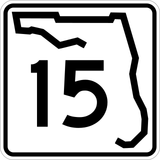
State Road 15 is part of the Florida State Road System. This route is part of a multi two-state route 15 that begins at Florida and ends at Georgia at the North Carolina state line.

U.S. Route 192 is an east–west route of the United States Numbered Highway system in central Florida. It runs 75.04 miles (120.77 km) from U.S. Route 27 in Four Corners, Lake County, east past Walt Disney World and through Kissimmee, St. Cloud and Melbourne, to end at State Road A1A in Indialantic, one block from the Atlantic Ocean. It crosses its "parent", U.S. Route 92, in Kissimmee, for only 3,700 feet (1,100 m).
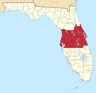
Central Florida is a region of the U.S. state of Florida. Different sources give different definitions for the region, but as its name implies it is usually said to comprise the central part of the state, including the Tampa Bay area and the Greater Orlando area, though in recent times the Tampa Bay area has often been described as its own region, with "central Florida" becoming more synonymous with the Orlando area.
Holopaw is an unincorporated community in Osceola County, Florida, United States. It is located at the eastern end of the multiplex of highways US 192 and US 441. It has a population of fewer than 5,000 people and is part of the Orlando-Kissimmee Metropolitan Statistical Area.

The Osceola Library System is a public library system serving Osceola County in Central Florida. The main branch is the Hart Memorial Central Library in historic downtown Kissimmee. The system has large branch locations in St. Cloud, Buenaventura Lakes, Poinciana, and West Osceola, as well as a small branch in Kenansville.

The Episcopal Diocese of Central Florida is a diocese in Florida in Province IV of the Episcopal Church. It is bounded on the north by the Episcopal Diocese of Florida, on the east by the Atlantic Ocean, on the south by the dioceses of Southeast Florida and Southwest Florida and on the west by the Gulf of Mexico. The two largest cities in the diocese are Orlando, with over 220,000 people, and Port St. Lucie, with over 150,000 people. The Kennedy Space Center and Walt Disney World are located within the diocese. Orlando, where St. Luke's Cathedral is located, is the see city of the diocese.

Lake Tohopekaliga, Tohopeka ; Tohopekaliga, also referred to as Lake Toho, West Lake, or simply Toho, is the largest lake in Osceola County, Florida, United States. It is the primary inflow of Shingle Creek, which rises in Orlando. It covers 22,700 acres (91.86 km2), and spans 42 miles (68 km) in circumference. It is linked to East Lake Tohopekaliga by Canal 31. The canal is 3 miles (5 km) long and runs through western St. Cloud. South Port canal is located at the southern tip of the lake and links it to Cypress Lake. It is 4 miles (6 km) long. Lake Toho is bordered on the northern shore by Kissimmee, on the eastern shore by Kissimmee Park, and South Port on the southern shore. Lake Tohopekaliga is known for its bass fishing and birdwatching. Lakefront Park is located at the North end of the lake and borders Lakeshore Blvd. Lakefront Park has a scenic walking path with benches where visitors may view the area's wide array of waterfowl, alligators, turtles and others. Lakefront park also has a miniature lighthouse, a children's playground area, and is bordered on its west end by Big Toho Marina.

East Lake Tohopekaliga is a lake in Osceola County, Florida, United States. It is the primary inflow of Boggy Creek, which rises in the Orlando International Airport at 70 feet (21 m) above sea level. Three places surround the lake, they are St. Cloud on the south shore, Narcoossee and Runnymede on the east shore.
The School District of Osceola County, Florida is a school district serving all of Osceola County, Florida. The district has 84 schools.
Shingle Creek is a small waterway in central Florida that is generally considered to be the northernmost headwaters of the Everglades watershed. It is named after the cypress trees that lined the bank in the late 19th century, which were used to make wood shingles. The stream and surrounding areas are protected wetlands.
William Jackson Brack was the first mayor of Orlando, Florida from 1875 to 1877. He served in the Florida House of Representatives from Brevard County from 1885 to 1887.
