Holiday, Florida

Last updated

Holiday, Florida
CDP
Pasco County Florida Incorporated and Unincorporated areas Holiday Highlighted.svg
Location in Pasco County and the state of Florida
Coordinates: 28°11′2″N82°44′34″W / 28.18389°N 82.74278°W / 28.18389; -82.74278
Country United States
State Florida
County Pasco
Area
[1]
  Total5.70 sq mi (14.76 km2)
  Land5.35 sq mi (13.85 km2)
  Water0.35 sq mi (0.90 km2)
Elevation
16 ft (5 m)
Population
 (2020)
  Total24,939
  Density4,662.37/sq mi (1,800.12/km2)
Time zone UTC-5 (Eastern (EST))
  Summer (DST) UTC-4 (EDT)
ZIP codes
34690-34691
Area code 727
FIPS code 12-31075 [2]
GNIS feature ID0284144 [3]

Holiday is a census-designated place (CDP) in Pasco County, Florida, United States. It is a suburb of the Tampa-St. Petersburg-Clearwater, Florida Metropolitan Statistical Area. The population was 24,939 as of the 2020 census.

Contents

In the early 1960s, William W. Boyd, president of First Federal Savings and Loan Association of Tarpon Springs, noted the name Holiday Drive on a map near the site of the proposed branch to be built in southwestern Pasco County and asked his board of directors to give the name to the new branch. Later Boyd began drumming up support to name the community Holiday.

Geography

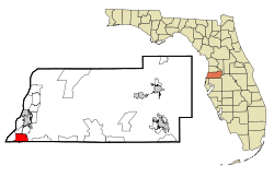
Holiday is located in west central Florida northwest of Tampa Bay on the Gulf of Mexico, at 28°11′2″N82°44′34″W / 28.18389°N 82.74278°W / 28.18389; -82.74278 (28.183890, −82.742886). [4]

Demographics

Historical population
CensusPop.Note
1980 18,392
1990 19,3605.3%
2000 21,90413.1%
2010 22,4032.3%
2020 24,93911.3%
source: [5]

As of the census [2] of 2010, there were 22,403 people and 9,505 households residing in the CDP. The racial makeup of the CDP was 82.7% White, 4.1% African American, 0.5% Native American, 1.4% Asian, and Hispanic or Latino of any race were 10.0% of the population. The population density per square mile was 4,168.8.

There were 9,505 households. The average persons living in a household was 2.31. The home ownership rate was 73.8%. The median value of owner-occupied units was $97,600. There were 12,484 housing units.

In the CDP, the population was spread out, with 20.0% of children under 18 (5.8% under 5) and 21.2% who were 65 years of age or older. The female population was 51.4%. High school graduates or higher of ages 25+ was 82.4%. Bachelor's degree or higher of ages 25+ was 10.1%. There were 2,887 veterans.

The per capita income was $19,947 and the median household income was $36,888.
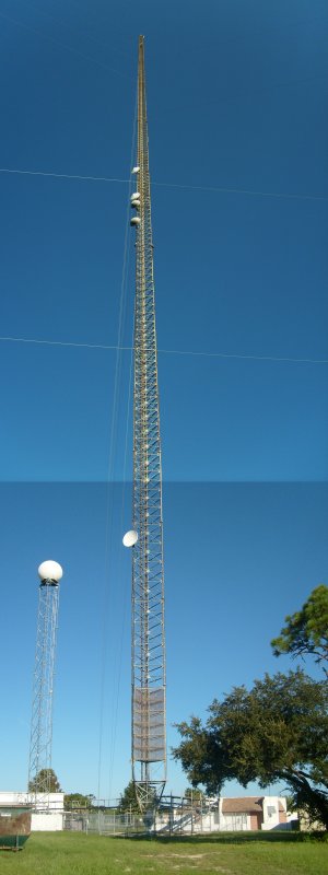
Infrastructure

Borders and neighborhoods

Holiday is bordered on the south by the City of Tarpon Springs/Pinellas County Line, the Gulf of Mexico on the west (with access from the Anclote River Park, Gulf Park, and Key Vista Park in Holiday), the city of New Port Richey to the north, and Trinity to the east.

Holiday is divided into many neighborhoods, which include:

Schools

Holiday is part of the Pasco County School System.

There are three elementary schools in Holiday:

There is one middle school:

There is one high school:

Private Schools:

Related Research Articles

<span class="mw-page-title-main">Pasco County, Florida</span> County in Florida, United States

Pasco County is located on the west central coast of the U.S. state of Florida. According to the 2020 census, the population was 561,691. Its county seat is Dade City, and its largest city is Zephyrhills. The county is named after Samuel Pasco.

<span class="mw-page-title-main">Homosassa, Florida</span> Census-designated place in Florida, United States

Homosassa is a census-designated place (CDP) in Citrus County, Florida, United States. The population was 2,578 at the 2010 census.

<span class="mw-page-title-main">Lecanto, Florida</span> Census-designated place in Florida, US

Lecanto is an unincorporated community and census-designated place (CDP) in Citrus County, Florida, United States. As of the 2010 census it had a population of 5,882, up from 5,161 in 2000. It is home to several county government facilities such as the Citrus County Sheriff's Office and the Citrus Campus of the College of Central Florida.

<span class="mw-page-title-main">Spring Hill, Florida</span> Census-designated place in Hernando County Florida, United States

Spring Hill is a census-designated place (CDP) in Hernando County, Florida, United States. The population was 113,568 at the 2020 census, up from 98,621 at the 2010 census. Spring Hill belongs to Florida's Nature Coast region and is in the Tampa-St. Petersburg-Clearwater metro area. It is east of Hernando Beach, southwest of Brooksville, and north of Tampa.

<span class="mw-page-title-main">Egypt Lake-Leto, Florida</span> Census-designated place in Florida, United States

Egypt Lake-Leto is a census-designated place (CDP) in an unincorporated part of Hillsborough County, Florida, United States. The CDP is located just north of Tampa International Airport. It is part of the Tampa Bay area. As of the 2020 US census, the population had 36,644 residents.

<span class="mw-page-title-main">Keystone, Florida</span> Census-designated place in Florida, United States

Keystone is an unincorporated census-designated place in Hillsborough County, Florida, United States. The Keystone area was first settled in the middle 1800s by the W.M. Mobley Family who migrated from Savannah, Georgia. The region has evolved from citrus and farming into a rural retreat of many lake homes and ranches. The population was 24,039 at the 2010 census, up from 14,627 at the 2000 census. The ZIP Codes encompassing the CDP area are 33556 and 33558.

<span class="mw-page-title-main">Lutz, Florida</span> Unincorporated Community in Florida, United States

Lutz is an unincorporated community in Hillsborough County and Pasco County, Florida, United States, 15 miles (24 km) north of Tampa. While there is a census-designated area of Lutz, the community itself extends beyond those boundaries into other census-designated areas.

<span class="mw-page-title-main">Thonotosassa, Florida</span> Census-designated place in Florida, United States

Thonotosassa is a census-designated place (CDP) in Hillsborough County, Florida, United States. The population was 15,238 at the 2020 census, up from 13,014 at the 2010 census.

<span class="mw-page-title-main">Kendale Lakes, Florida</span> Census-designated place in Florida

Kendale Lakes is a census-designated place (CDP) and a suburb of Miami in Miami-Dade County, Florida, United States. It is located in the Miami metropolitan area of South Florida. The population was 55,646 at the 2020 census.

<span class="mw-page-title-main">Hunter's Creek, Florida</span> Census-designated place in Florida, United States

Hunter's Creek is a master planned, unincorporated community and census-designated place in Orange County, Florida, United States. It is part of the Orlando–Kissimmee–Sanford, Florida Metropolitan Statistical Area. The population was 14,321 at the 2010 census. It has grown up around a large planned community named Hunter's Creek, though the CDP name given by the United States Census Bureau lacks the apostrophe.

<span class="mw-page-title-main">Elfers, Florida</span> CDP in Florida, United States

Elfers is a census-designated place (CDP) in Pasco County, Florida, United States. The population was 13,161 at the 2000 census.

<span class="mw-page-title-main">Lacoochee, Florida</span> CDP in Florida, United States

Lacoochee is a census-designated place (CDP) in Pasco County, Florida, United States. The population was 1,345 at the 2000 census.

<span class="mw-page-title-main">Land o' Lakes, Florida</span> Census-designated place in Florida, United States

Land O' Lakes is a census-designated place (CDP) in Pasco County, Florida, United States. It is part of the Tampa-St. Petersburg-Clearwater, Florida MSA. As of the 2020 US census, the CDP had a population of 35,929.

<span class="mw-page-title-main">New Port Richey, Florida</span> City in Florida

New Port Richey is a city in Pasco County, Florida, United States. It is a suburban city included in the Tampa-St. Petersburg-Clearwater, Florida Metropolitan Statistical Area. The population was counted at 16,728 in the 2020 census.

<span class="mw-page-title-main">Odessa, Florida</span> CDP in Florida, United States

Odessa is a census-designated place (CDP) in Pasco County, Florida, United States. The population was 3,173 at the 2000 census and more than doubled to 7,267 in 2010. Northwest of Tampa, Odessa had been an area of open spaces, ranching, and horse properties. More recently it has seen many suburban property developments as Tampa's population expands.

<span class="mw-page-title-main">Trinity, Florida</span> CDP in Florida, United States

Trinity is a census-designated place (CDP) in Pasco County, Florida, United States. The population was 10,907 in 2010, according to the most recent census. The Trinity Community is named after Trinity College of Florida, a Bible college founded in 1932, when it relocated to the first occupied site in the communities developed by James Gills in the late 1980s. The main plaza is found near the high school, known as Mitchell Ranch Plaza. Trinity is located at the junction where Pasco, Hillsborough and Pinellas Counties meet. The community of Longleaf is located in Trinity and it is believed that the “Welcome Plank” originated in Longleaf.

<span class="mw-page-title-main">Wesley Chapel, Florida</span> CDP in Florida, United States

Wesley Chapel is a census-designated place in Pasco County, Florida, United States. Wesley Chapel is a suburb in the Tampa Bay Area.

<span class="mw-page-title-main">East Lake, Pinellas County, Florida</span> Census-designated place in Florida, United States

East Lake is a census-designated place (CDP) in Pinellas County, Florida, United States. The population was 30,962 at the 2010 census. It was one of the last areas in the densely populated county to develop. It is often confused with East Lake in neighboring Hillsborough County.

<span class="mw-page-title-main">Palm Harbor, Florida</span> Census-designated place in Florida, United States

Palm Harbor is a census-designated place (CDP) and unincorporated community in Pinellas County, Florida, United States. As of the 2020 census, the CDP had a population of 61,366.

<span class="mw-page-title-main">Aripeka, Florida</span> Census-designated place & Unincorporated Community in Florida, United States

Aripeka is an unincorporated community and census-designated place (CDP) in the U.S. state of Florida, along coast of the Gulf of Mexico at the border dividing Pasco and Hernando counties. The ZIP Code for the community is 34679, but it was originally assigned as 33502. As of the 2020 census, the population was 320.

References

  1. "2020 U.S. Gazetteer Files". United States Census Bureau. Retrieved October 31, 2021.
  2. 1 2 "U.S. Census website". United States Census Bureau . Retrieved January 31, 2008.
  3. "US Board on Geographic Names". United States Geological Survey. October 25, 2007. Retrieved January 31, 2008.
  4. "US Gazetteer files: 2010, 2000, and 1990". United States Census Bureau. February 12, 2011. Retrieved April 23, 2011.
  5. "CENSUS OF POPULATION AND HOUSING (1790-2010)". U.S. Census Bureau . Retrieved July 18, 2010.
  6. "Geocaching - the Official Global GPS Cache Hunt Site".