The Erie Canal is a canal in New York, United States that is part of the east–west, cross-state route of the New York State Canal System. Originally, it ran 363 miles (584 km) from where Albany meets the Hudson River to where Buffalo meets Lake Erie. It was built to create a navigable water route from New York City and the Atlantic Ocean to the Great Lakes. When completed in 1825, it was the second longest canal in the world and greatly affected the development and economy of New York, New York City, and the United States.

Boca Raton is the southernmost city in Palm Beach County, Florida, United States, first incorporated on August 2, 1924 as "Bocaratone," and then incorporated as "Boca Raton" in 1925. The 2015 population estimated by the U.S. Census Bureau was 93,235. However, approximately 200,000 people with a Boca Raton postal address reside outside its municipal boundaries. Such areas include newer developments like West Boca Raton. As a business center, the city also experiences significant daytime population increases. It is one of the wealthiest communities in South Florida. Boca Raton is 43 miles (69 km) north of Miami and is a principal city of the Miami metropolitan area, which had a population of 6,012,331 people as of 2015.
Volusia County is located in the east-central part of the U.S. state of Florida, stretching between the St. Johns River and the Atlantic Ocean. As of the 2010 census, the county was home to 494,593 people, an increase of 11.6% from 2000. It was founded on December 29, 1854 from part of Orange County and was named for the community of Volusia, located in northwestern Volusia County. Its first county seat was Enterprise. Since 1887, its county seat has been DeLand.

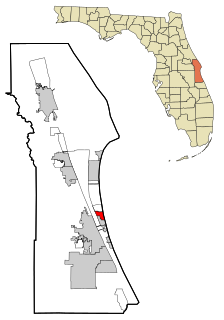
Panama City is a city and the county seat of Bay County, Florida, United States. Located along U.S. Route 98, it is the largest city between Tallahassee and Pensacola. It is the more populated of two principal cities of the Panama City-Lynn Haven, Florida Metropolitan Statistical Area. As of the 2010 census, the population was 36,484. The city was catastrophically damaged when Hurricane Michael made landfall as a Category 5 hurricane on October 10, 2018.
Satellite Beach is a coastal city situated in Brevard County, Florida. The population was 10,109 at the 2010 United States Census, and it is located with the Atlantic Ocean to the east and the Indian River to the west.
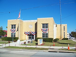
Port St. Joe is a city located at the intersection of U.S. Highway 98 and State Road 71 in Gulf County, Florida, United States. As of the 2010 census the population was 3,445. This was a decline from 3,644 as of the 2000 census. Port St. Joe is the county seat of Gulf County.

Hudson is a census-designated place (CDP) located at the westernmost end of Pasco County, Florida, United States and is included in the Tampa-St. Petersburg-Clearwater, Florida Metropolitan Statistical Area. As of the 2010 census, Hudson's population was 12,158. Since Hudson is an integrated city, it doesn't have an official mayor, although the West Pasco Chamber of Commerce has recognized Bryan Farrow as the ceremonial Mayor of Hudson since 2012.

The Gulf Intracoastal Waterway is the portion of the Intracoastal Waterway located along the Gulf Coast of the United States. It is a navigable inland waterway running approximately 1,050 mi (1,690 km) from Carrabelle, Florida, to Brownsville, Texas.

Oneida Lake is the largest lake entirely within New York State, with a surface area of 79.8 square miles (207 km2). The lake is located northeast of Syracuse and near the Great Lakes. It feeds the Oneida River, a tributary of the Oswego River, which flows into Lake Ontario. From the earliest times until the opening of the Erie Canal in 1825, the lake was part of an important waterway connecting the Atlantic seaboard of North America to the continental interior.

The Caloosahatchee River is a river on the southwest Gulf Coast of Florida in the United States, approximately 67 miles (108 km) long. It drains rural areas on the northern edge of the Everglades, east of Fort Myers. An important link in the Okeechobee Waterway, a manmade inland waterway system of southern Florida, the river forms a tidal estuary along most of its course and has become the subject of efforts to restore and preserve the Everglades.

The Miami metropolitan area, also known as the Greater Miami Area or South Florida, is the 73rd largest metropolitan area in the world and the seventh-largest metropolitan area in the United States. Located in southern Florida with 6,198,782 inhabitants as of 2018, the Miami metropolitan area is the most populous in Florida and second largest in the southeastern United States. It extends about 120 miles from north to south.

Port Mayaca is a sparsely populated place located in western Martin County, Florida, United States, on the eastern side of Lake Okeechobee.
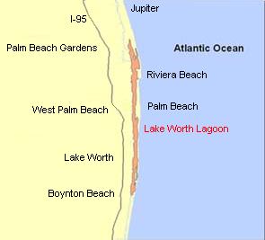
The Lake Worth Lagoon is a lagoon located in Palm Beach County, Florida. It runs parallel to the coast, and is separated from the Atlantic Ocean by barrier beaches, including Palm Beach Island. The lagoon is connected to the Atlantic Ocean by two permanent, man-made inlets.

The Rickenbacker Causeway is a causeway which connects Miami, Florida, United States to the barrier islands of Virginia Key and Key Biscayne across Biscayne Bay.

The Port of New York and New Jersey is the port district of the New York-Newark metropolitan area, encompassing the region within approximately a 25-mile (40 km) radius of the Statue of Liberty National Monument. It includes the system of navigable waterways in the New York–New Jersey Harbor Estuary, which runs along 650 miles (1,050 km) of shoreline in the vicinity of New York City and northeastern New Jersey, as well as the region's airports and supporting rail and roadway distribution networks. Considered one of the largest natural harbors in the world, the port is by tonnage the third largest in the United States and the busiest on the East Coast.
Cross Creek is an unincorporated community in Alachua County, Florida, United States. It is located on Cross Creek, a short stream connecting Orange and Lochloosa lakes.
The Barnegat Peninsula, also known as the Island Beach Peninsula or Barnegat Bay Island and colloquially as "the barrier island", is a 20-mile (32 km) long, narrow barrier peninsula located on the Jersey Shore in Ocean County, New Jersey, United States, that divides the Barnegat Bay from the Atlantic Ocean. It is a vacation destination and summer colony area and is heavily dependent on tourism, real estate and fishing. Notable communities on the peninsula include Point Pleasant Beach, Bay Head, Mantoloking, Lavallette, Ortley Beach, Seaside Heights, Seaside Park and the South Seaside Park section of Berkeley Township. The southern 10 miles (16 km) of the barrier island are preserved in their natural state as Island Beach State Park, New Jersey's longest stretch of undeveloped coastline.
Clearwater Beach includes a resort area and a residential area on the Gulf of Mexico in Pinellas County on the west central coast of Florida. Located just west over the Intracoastal Waterway by way of the Clearwater Memorial Causeway from the city of Clearwater, Florida, of which it is part, Clearwater Beach is at a geographic latitude of 27.57 N and longitude 82.48 W.
The Lakes to Locks Passage is a scenic byway in northeastern New York in the United States and in southern Quebec in Canada. The byway unifies the interconnected waterway of the upper Hudson River, Champlain Canal, Lake George, and Lake Champlain; this waterway is the core of North America’s first "super-highway" between upstate New York and the Canadian province of Quebec. The initiatives of the Lakes to Locks Passage aim to unify the byway corridor as a single destination. The US portion of the passage is a New York State Scenic Byway, a National Scenic Byway, and an All-American Road.

Greenbriar is an unincorporated community and census-designated place (CDP) in Pinellas County, Florida, United States. The population was 2,502 at the 2010 census.