Zephyrhills North, Florida

Last updated

Zephyrhills North, Florida
CDP
Pasco County Florida Incorporated and Unincorporated areas Zephyrhills North Highlighted.svg
Location in Pasco County and the state of Florida
Coordinates: 28°15′0″N82°9′56″W / 28.25000°N 82.16556°W / 28.25000; -82.16556
Country United States
State Florida
County Pasco
Area
[1]
  Total0.99 sq mi (2.57 km2)
  Land0.99 sq mi (2.57 km2)
  Water0.00 sq mi (0.00 km2)
Population
 (2020)
  Total2,663
  Density2,684.48/sq mi (1,036.06/km2)
Time zone UTC-5 (Eastern (EST))
  Summer (DST) UTC-4 (EDT)
FIPS code 12-79231 [2]

Zephyrhills North is a census-designated place (CDP) in Pasco County, Florida, United States. The population was 2,544 at the 2000 census.

Contents

Geography

Zephyrhills North is located at 28°15′0″N82°9′56″W / 28.25000°N 82.16556°W / 28.25000; -82.16556 (28.250083, -82.165528). [3]

According to the United States Census Bureau, the CDP has a total area of 1.1 square miles (2.8 km2), all land.

Demographics

Historical population
CensusPop.Note
1980 1,710
1990 2,32035.7%
2000 2,5449.7%
2020 2,663
source: [4]

As of the census [2] of 2000, there were 2,544 people, 1,298 households, and 842 families residing in the CDP. The population density was 2,360.0 inhabitants per square mile (911.2/km2). There were 1,889 housing units at an average density of 1,752.4 per square mile (676.6/km2). The racial makeup of the CDP was 94.34% White, 1.14% African American, 0.67% Native American, 1.38% Asian, 0.04% Pacific Islander, 1.06% from other races, and 1.38% from two or more races. Hispanic or Latino of any race were 3.30% of the population.

There were 1,298 households, out of which 13.1% had children under the age of 18 living with them, 54.7% were married couples living together, 8.8% had a female householder with no husband present, and 35.1% were non-families. 31.0% of all households were made up of individuals, and 22.0% had someone living alone who was 65 years of age or older. The average household size was 1.96 and the average family size was 2.37.

In the CDP, the population was spread out, with 12.9% under the age of 18, 4.8% from 18 to 24, 14.6% from 25 to 44, 20.3% from 45 to 64, and 47.4% who were 65 years of age or older. The median age was 64 years. For every 100 females, there were 81.5 males. For every 100 females age 18 and over, there were 79.1 males.

The median income for a household in the CDP was $29,462, and the median income for a family was $32,897. Males had a median income of $28,214 versus $20,529 for females. The per capita income for the CDP was $16,344. About 6.6% of families and 10.7% of the population were below the poverty line, including 24.2% of those under age 18 and 5.3% of those age 65 or over.

Related Research Articles

<span class="mw-page-title-main">Sells, Arizona</span> CDP in Pima County, Arizona

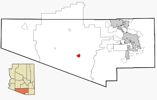
Sells is an unincorporated community and census-designated place (CDP) in Pima County, Arizona, United States. The population was 2,799 at the 2000 census. It is the capital of the Tohono O'odham Nation and the home of several of their tribal businesses, such as Tohono O'Odham Ki:Ki Association. Originally named Indian Oasis, by cattle-ranchers/businessmen brothers, Joseph and Louis Ménager in 1912. The Ménager brothers also built and ran the Indian Oasis Mercantile Store. The settlement took its present English name in 1918 to honor Indian Commissioner Cato Sells. The O'odham name means "Tortoise Got Wedged".

<span class="mw-page-title-main">Washington Park, Florida</span> CDP in Florida, United States

Washington Park is a census-designated place (CDP) in Broward County, Florida, United States. Its population was 1,948 at the 2020 census.

<span class="mw-page-title-main">North Brooksville, Florida</span> Census-designated place in Florida, United States

North Brooksville is a census-designated place (CDP) in Hernando County, Florida, United States. The population was 3,544 at the 2010 census. It is a suburb included in the Tampa-St. Petersburg-Clearwater, Florida Metropolitan Statistical Area.

<span class="mw-page-title-main">East Lake-Orient Park, Florida</span> Census-designated place in Florida, United States

East Lake-Orient Park is an unincorporated census-designated place in Hillsborough County, Florida, United States. The population was 22,753 at the 2010 census, up from 5,703 at the 2000 census following an expansion of its borders. The area is the home of the Florida State Fairgrounds, which hosts the Florida State Fair in mid-February of each year. It was previously home to East Lake Square Mall. The ZIP code for East Lake-Orient Park is 33610 and 33619.

<span class="mw-page-title-main">Thonotosassa, Florida</span> Census-designated place in Florida, United States

Thonotosassa is a census-designated place (CDP) in Hillsborough County, Florida, United States. The population was 15,238 at the 2020 census, up from 13,014 at the 2010 census.

<span class="mw-page-title-main">West Bradenton, Florida</span> Census-designated place in Florida, United States

West Bradenton is an unincorporated area and census-designated place (CDP) in Manatee County, Florida, United States. The population was 4,247 at the 2020 census. It is part of the Bradenton–Sarasota–Venice Metropolitan Statistical Area.

High Point was a census-designated place (CDP) in Palm Beach County, Florida, United States. The population was 2,191 at the 2000 census. The CDP was removed from the 2010 census. Although it is still unincorporated, it is within Delray Beach's "future annexation area."

<span class="mw-page-title-main">Crystal Springs, Florida</span> CDP in Florida, United States

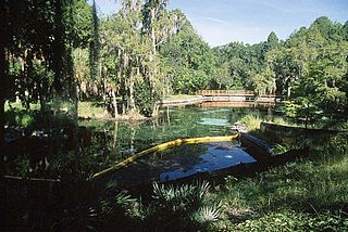
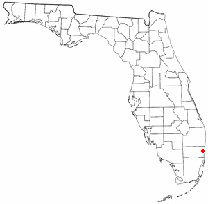
Crystal Springs is a hydrological spring and a census-designated place (CDP) in Pasco County, Florida, United States. The population was 1,175 at the 2000 census.

<span class="mw-page-title-main">Shady Hills, Florida</span> CDP in Florida, United States

Shady Hills is a census-designated place (CDP) in Pasco County, Florida, United States. The population was 7,798 at the 2000 census. It is in the Tampa-St. Petersburg-Clearwater, Florida Metropolitan Statistical Area. It is home to an active pigeon racing group.

<span class="mw-page-title-main">Zephyrhills South, Florida</span> CDP in Florida, United States

Zephyrhills South is a census-designated place (CDP) in Pasco County, Florida, United States. The population was 4,435 at the 2000 census.

<span class="mw-page-title-main">Zephyrhills West, Florida</span> CDP in Florida, United States

Zephyrhills West is a census-designated place (CDP) in Pasco County, Florida, United States. The population was 5,242 at the 2000 census.

<span class="mw-page-title-main">Kurtistown, Hawaii</span> Census-designated place in Hawaii, U.S.

Kurtistown is a census-designated place (CDP) in Hawaiʻi County, Hawaiʻi, United States, in the District of Puna. The population was 1,298 at the 2010 census, up from 1,157 at the 2000 census.

<span class="mw-page-title-main">Waipiʻo Acres, Hawaii</span> Census-designated place in Hawaii, United States

Waipiʻo Acres is a census-designated place (CDP) in Honolulu County, Hawaiʻi, United States. The population was 5,531 at the 2020 census.

Jamestown West is a census-designated place (CDP) located near Jamestown in Chautauqua County, New York, United States. Also known as West Ellicott because of its location in the Town of Ellicott, the area population was 2,408 as of the 2010 census.

<span class="mw-page-title-main">Hays, North Carolina</span> CDP in North Carolina, United States

Hays is a census-designated place (CDP) in Wilkes County, North Carolina, United States. The population was 1,595 at the 2020 census. North Wilkes High School, one of Wilkes County's four public high schools, is located in Hays.

<span class="mw-page-title-main">Lime Ridge, Pennsylvania</span> Census-designated place in Pennsylvania, United States

Lime Ridge is a census-designated place (CDP) in Columbia County, Pennsylvania, United States. It is part of Northeastern Pennsylvania. The population was 890 at the 2010 census. It is part of the Bloomsburg-Berwick micropolitan area.

Wedgefield is a census-designated place (CDP) in Sumter County, South Carolina, United States. The population was 1,544 at the 2000 census.

Howland is a census-designated place (CDP) in Penobscot County, Maine, United States. The population was 1,096 at the 2010 census.

<span class="mw-page-title-main">Pine Plains (CDP), New York</span> Census-designated place in New York, United States

Pine Plains is a hamlet and census-designated place (CDP) in Dutchess County, New York, United States. The population was 1,142 at the 2020 census. It is part of the Poughkeepsie–Newburgh–Middletown, NY Metropolitan Statistical Area as well as the larger New York–Newark–Bridgeport, NY-NJ-CT-PA Combined Statistical Area.

<span class="mw-page-title-main">Milo (CDP), Maine</span> CDP in Maine, United States

Milo is a census-designated place (CDP) in the town of Milo in Piscataquis County, Maine, United States. The population was 1,898 at the 2000 census.

References

  1. "2020 U.S. Gazetteer Files". United States Census Bureau. Retrieved December 2, 2021.
  2. 1 2 "U.S. Census website". United States Census Bureau . Retrieved January 31, 2008.
  3. "US Gazetteer files: 2010, 2000, and 1990". United States Census Bureau. February 12, 2011. Retrieved April 23, 2011.
  4. "CENSUS OF POPULATION AND HOUSING (1790-2000)". U.S. Census Bureau . Retrieved July 18, 2010.