
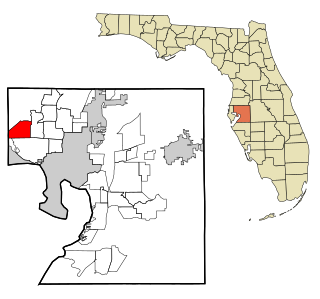
Charlotte Harbor is a census-designated place (CDP) in Charlotte County, Florida, United States. The name Charlotte Harbor also refers to Charlotte Harbor (estuary) and Charlotte Harbor Preserve State Park, a 42,000-acre (17,000 ha) preserve with 70 miles (110 km) of shoreline along Charlotte Harbor in Charlotte County.
Westchase is a census-designated place (CDP) in Hillsborough County, Florida, United States. The population was 21,747 at the 2010 census, up from 11,116 at the 2000 census. The census area encompasses most of the 33626 ZIP code area.

Palm Harbor is a census-designated place and unincorporated community in Pinellas County, Florida, United States. As of the 2016 American Community Survey, the CDP had a population of 60,236.

Monhegan is an island in the Gulf of Maine located in Lincoln County, Maine, United States. A plantation, a minor civil division in the state of Maine falling between unincorporated area and a town, it is located about 12 nautical miles (22 km) off the mainland. The population was 64 at the 2020 census. The plantation comprises its namesake island and the uninhabited neighboring island of Manana. The island is accessible by scheduled boat service from Boothbay Harbor, New Harbor and Port Clyde. Visitors' cars are not allowed on the island. It was designated a National Natural Landmark for its coastal and island flora in 1966.

Stone Harbor is a borough in Cape May County, New Jersey, United States, that is part of the Ocean City Metropolitan Statistical Area. It occupies the southern portion of Seven Mile Island together with its northern neighbor Avalon. It is a resort community that attracts visitors looking to enjoy its beaches, sailing facilities and commercial center. The community attracts a large number of vacationers from the Mid-Atlantic region and Quebec. The borough has a summer population in excess of 20,000, though as of the 2010 United States Census, the borough had a year-round population of 866, reflecting a decline of 262 (−23.2%) from the 1,128 counted in the 2000 Census, which had in turn increased by 103 (+10.0%) from the 1,025 counted in the 1990 Census. In general, summer visitors are wealthier than full-time residents.

Gulf St Vincent, sometimes referred to as St Vincent Gulf, St Vincent's Gulf or Gulf of St Vincent, is the eastern of two large inlets of water on the southern coast of Australia, in the state of South Australia, the other being the larger Spencer Gulf, from which it is separated by Yorke Peninsula. On its eastern side the gulf is bordered by the Adelaide Plains and the Fleurieu Peninsula.

Princeton-by-the-Sea is an unincorporated community on the coast of San Mateo County, California. The ZIP code is 94019 and the community is inside area code 650.

Charlotte Harbor Estuary, the second largest bay in Florida, is located on the Gulf of Mexico coast of west Florida with two thirds lying in Charlotte County, Florida and one in Lee County. The harbor's mouth is located behind Gasparilla Island, one of the many coastal barrier islands on the southwest coast of Florida, with access from the Gulf of Mexico through the Boca Grande Pass between Gasparilla Island on the north and Lacosta Island on the south. Charlotte Harbor covers about 270 sq mi (700 km2)
Van Lear is an unincorporated community and coal town in Johnson County, Kentucky, United States.

Aripeka is an unincorporated community and census-designated place (CDP) in the U.S. state of Florida, along coast of the Gulf of Mexico at the border dividing Pasco and Hernando counties. The ZIP Code for the community is 34679, but it was originally assigned as 33502. As of the 2020 census, the population was 320.

Havana Harbor is the port of Havana, the capital of Cuba, and it is the main port in Cuba. Other port cities in Cuba include Cienfuegos, Matanzas, Manzanillo, and Santiago de Cuba.

Barnard Point is a headland which marks the south-east side of the entrance to False Bay on the south side of Livingston Island in the South Shetland Islands, Antarctica. It is situated on Rozhen Peninsula, 1.5 km (1 mi) north-north-west of Botev Point and 6.6 km (4 mi) south-east of Miers Bluff.
Fitchville is an unincorporated community in Fitchville Township, Huron County, Ohio, United States. It is part of the Norwalk Micropolitan Statistical Area. Fitchville is located at the intersection of U.S. Route 250, State Route 13, and State Route 162. The community has no post office of its own and is assigned the New London zip code of 44851. The Mansion Hotel was a prominent Fitchville landmark for one hundred and thirty years from 1839 to 1968. It was reputed to have hosted Abraham Lincoln, and served as an overnight resting place for many escaping slaves travelling on the "underground railroad".
Fuhrmans Mill is an unincorporated community in York County, Pennsylvania, United States.

Marina Piccola is located on the southern side of the island of Capri. It is near the Faraglioni sea stacks to the southeast. The Via Krupp is a historic switchback paved footpath which connect the Charterhouse of San Giacomo and the Gardens of Augustus area with Marina Piccola. The Marina Piccola, used by Augustus and Tiberius, preceded the Marina Grande.
Nettleton is an unincorporated community in Caldwell County, in the U.S. state of Missouri.
Steinmetz is an unincorporated community in Howard County, in the U.S. state of Missouri.
Ludwig is an unincorporated community in Jefferson County, in the U.S. state of Missouri. The community was named for an individual identified as "Mr. Ludwig," who produced lime in the area.
Van Cleve is an unincorporated community in Maries County, in the U.S. state of Missouri.The original Van Cleve was located on Road 222 and was platted as a town-later the post office and town’s name moved 1/4 mile past Carnes Branch off of hwy 133
Lippstadt Community is an unincorporated community in Warren County, in the U.S. state of Missouri.
