
Pinellas County is located on the west central coast of the state of Florida. As of the 2010 census, the population was 916,542. The county is part of the Tampa–St. Petersburg–Clearwater, Florida Metropolitan Statistical Area. Clearwater is the county seat, and St. Petersburg is the largest city and the largest city in Florida that is not a county seat.
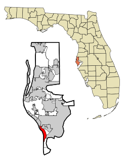
St. Pete Beach is a coastal city in Pinellas County, Florida, United States. Known as a tourist destination, St. Pete Beach was formed from the towns of Pass-a-Grille, Belle Vista, St. Petersburg Beach and unincorporated Pinellas County. At the time of its incorporation in 1957, its name was St. Petersburg Beach. On March 9, 1994, locals voted to officially change the name to the shorter version of St. Pete Beach, to distinguish it from the city of St. Petersburg a few miles to the east. The population was 9,346 at the 2010 census.

Tierra Verde is a census-designated place (CDP) in Pinellas County, Florida, United States. The population was 3,721 at the 2010 census. The community is located on an island near the entrance of Tampa Bay, and is connected by the bridges of the Pinellas Bayway to both St. Petersburg and St. Pete Beach. At the southern end of Tierra Verde is Fort De Soto, a county park.

The State Highway System of the U.S. state of Florida comprises the roads maintained by the Florida Department of Transportation (FDOT) or a toll authority. The components are referred to officially as state roads, abbreviated SR.
State Road A1A (SR A1A) is a north–south Florida State Road that runs along the Atlantic Ocean, from Key West at the southern tip of Florida, to Fernandina Beach, just south of Georgia on Amelia Island. It is the main road through most oceanfront towns. Part of SR A1A is designated the A1A Scenic and Historic Coastal Byway, a National Scenic Byway. A portion of SR A1A that passes through Volusia County is designated the Ormond Scenic Loop and Trail, a Florida Scenic Highway. It is also called the Indian River Lagoon Scenic Highway from State Road 510 at Wabasso Beach to U.S. Route 1 in Cocoa. SR A1A is famous worldwide as a center of beach culture in the United States, a scenic coastal route through most Atlantic coastal cities and beach towns, including the unique tropical coral islands of the Florida Keys. SR A1A also serves as a major thoroughfare through Miami Beach and other south Florida coastal cities.

The Pinellas Bayway System is a series of bridges on two state roads in Pinellas County, Florida. It is a toll road complex maintained and operated by the Florida Department of Transportation. It also is compatible with the SunPass ETC system currently in use on all other FDOT-owned toll roads. The Pinellas Bayway consists of:

Treasure Island Causeway is a series of three bridges crossing Boca Ciega Bay between Treasure Island and St. Petersburg in Pinellas County, Florida. The bridge, which carries County Road 150 (CR 150), is owned and maintained by the City of Treasure Island, which used to charge all motorists $1.00 toll, until June, 2006, when the first span of the bridge was reopened with no toll booth. Residents of two St. Petersburg waterfront communities used to pay a $10 annual road tax to the City of Treasure Island to help support road and median maintenance. That tax was eliminated in the spring of 2007. Treasure Island's ownership of the causeway in St. Petersburg was part of a land agreement entered into when these two cities were born: St. Petersburg's founding fathers purchased the Municipal Beach on the shores of the neighboring Gulf of Mexico community, Treasure Island, outside its own city limits to ensure that residents would have direct access to the Gulf of Mexico for generations to come. The western terminus is an intersection with Gulf of Mexico Boulevard in Treasure Island.
Locally known as Gulf Boulevard and Blind Pass Road, State Road 699 is a 15-mile-long road running the length of the Pinellas County barrier islands in the Gulf of Mexico and serving the popular beaches near St. Petersburg, Clearwater, and Largo. The southern terminus of SR 699 is at the extreme western end of Pinellas Bayway in St. Pete Beach; the northern terminus is the extreme western end of SR 688 in Indian Rocks Beach. State Road 699 is the closest Gulf Coast analog to SR A1A on the Atlantic coast of Florida: indeed, the southernmost two miles (3 km) of SR 699 are part of a loop that Florida Department of Transportation designated as A19A.
State Road 688 is an east–west route in Pinellas County running from Indian Rocks Beach to northeastern St. Petersburg, Florida, where it merges onto Interstate 275 (I-275).
State Road 693 is a 11.6-mile-long (18.7 km) north–south street serving southern Pinellas County, Florida. Locally known as 66th Street, Pasadena Avenue, and A19A, the southern terminus is an intersection with Blind Pass Road and Gulf Way in St. Pete Beach, near the southern end of the Corey Causeway; the northern terminus is an intersection with U.S. Route 19 within the Largo city limits.
State Road 686 is an east–west route in Pinellas County, running from U.S. Route 19 Alternate in Largo east to an intersection with SR 687 and SR 694 in St. Petersburg, Florida. Originally, SR 686 extended further west, ending at Gulf Boulevard in Belleair Beach, next to the shores of the Gulf of Mexico.
State Road 694 (SR 694) is an east–west route in Pinellas County, running from SR 693 in Pinellas Park to U.S. Route 92 in St. Petersburg.
U.S. Highway 1 (US 1) in Florida runs 545 miles (877 km) along the state's east coast– from Key West to its crossing of the St. Marys River into Georgia north of Boulogne –and south of Folkston. US 1 was designated through Florida when the United States Numbered Highway System was established in 1926. The road is maintained by the Florida Department of Transportation (FDOT).

U.S. Route 19 Alternate is a 37.1-mile (59.7 km) former section of U.S. Route 19 from St. Petersburg, Florida to Holiday.
State Road 666 (SR 666) is a short state road in Pinellas County. Locally known as Tom Stuart Causeway, Welch Causeway, or Madeira Beach Causeway, the route crosses Boca Ciega Bay from Seminole to Madeira Beach. The bridge crossing Boca Ciega Bay is a bascule bridge with 11 spans, built in 1962. The route ends with an interchange with U.S. Route 19 Alternate in Bay Pines. The southwestern terminus of the route is at State Road 699 in Madeira Beach, in front of the Ocean Sands hotel.

U.S. Route 19 runs 264 miles (425 km) along Florida's west coast from an interchange with U.S. Route 41 in Memphis, Florida, south of Tampa, and continues to the Georgia border north of Monticello, Florida.
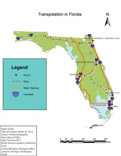
Transportation in Florida includes a variety of options, including Interstate Highways, U.S. Highways, and Florida State Roads; Amtrak and commuter rail services; airports, public transportation, and sea ports, in a number of the state's counties and regions.

The Corey Causeway is a series of three twin-span bridges that cross the Boca Ciega Bay, part of the Gulf Intracoastal Waterway. The causeway carries SR 693. The two east bridges are fixed bridges, and the west bridge is a double-leaf bascule bridge. It connects the barrier islands of St. Pete Beach and the mainland of South Pasadena, Florida. The westbound span of the Corey Causeway was built in 1966, and the eastbound span was built in 1975, which replaced the original causeway built in the 1930s.
