Floridian highlands freshwater marsh

Last updated

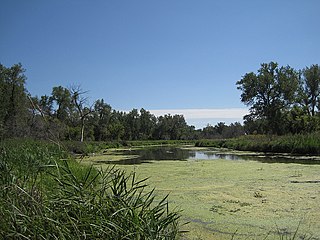
The Floridian highlands freshwater marsh is a wetland community found on the Florida peninsula. These are upland marshes occurring in shallow peat-filled valleys, the basins of dried lakes, and the borders of existing lakes. The vegetation mosaic includes a range of mostly herbaceous plant communities, varying based on water depth. Deep water supports various submerged and floating plants. Approximately meter-deep supports emergent herbaceous perennials, typically in dense, monospecific stands; species include bulrush ( Typha latifolia ), pickerelweed ( Pontederia cordata ), American lotus ( Nelumbo lutea ). Shallow areas only submerged during wet season support more graminoid vegetation, including maidencane ( Panicum hemitomon ) and southern cutgrass ( Leersia hexandra ). Subsurface subsidence and changing drainage patterns make these habitats shift and change over time. Soils can be mucky, loamy, or sandy, but they are generally above permeable subsoils that create standing water much of the year. These marshes may also be called meadows or prairies. [1]

Wetland A land area that is permanently or seasonally saturated with water

A wetland is a distinct ecosystem that is inundated by water, either permanently or seasonally, where oxygen-free processes prevail. The primary factor that distinguishes wetlands from other land forms or water bodies is the characteristic vegetation of aquatic plants, adapted to the unique hydric soil. Wetlands play a number of functions, including water purification, water storage, processing of carbon and other nutrients, stabilization of shorelines, and support of plants and animals. Wetlands are also considered the most biologically diverse of all ecosystems, serving as home to a wide range of plant and animal life. Whether any individual wetland performs these functions, and the degree to which it performs them, depends on characteristics of that wetland and the lands and waters near it. Methods for rapidly assessing these functions, wetland ecological health, and general wetland condition have been developed in many regions and have contributed to wetland conservation partly by raising public awareness of the functions and the ecosystem services some wetlands provide.

Florida State of the United States of America

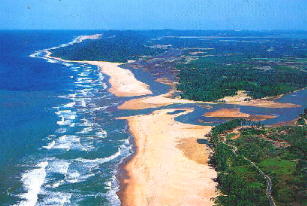
Florida is the southernmost contiguous state in the United States. The state is bordered to the west by the Gulf of Mexico, to the northwest by Alabama, to the north by Georgia, to the east by the Atlantic Ocean, and to the south by the Straits of Florida. Florida is the 22nd-most extensive, the 3rd-most populous, and the 8th-most densely populated of the U.S. states. Jacksonville is the most populous municipality in the state and the largest city by area in the contiguous United States. The Miami metropolitan area is Florida's most populous urban area. Tallahassee is the state's capital.

Marsh A wetland that is dominated by herbaceous rather than woody plant species

A marsh is a wetland that is dominated by herbaceous rather than woody plant species. Marshes can often be found at the edges of lakes and streams, where they form a transition between the aquatic and terrestrial ecosystems. They are often dominated by grasses, rushes or reeds. If woody plants are present they tend to be low-growing shrubs. This form of vegetation is what differentiates marshes from other types of wetland such as swamps, which are dominated by trees, and mires, which are wetlands that have accumulated deposits of acidic peat.

Examples include Paynes Prairie and the marshes along the Kissimmee and St. Johns River. [1]

Kissimmee River River in Florida, United States

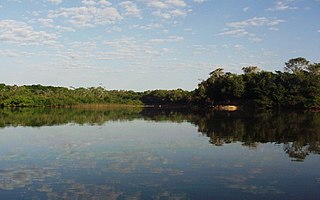
The Kissimmee River is a river in south-central Florida, United States.

St. Johns River The longest river in Florida, United States

The St. Johns River is the longest river in the U.S. state of Florida and its most significant one for commercial and recreational use. At 310 miles (500 km) long, it flows north and winds through or borders twelve counties. The drop in elevation from headwaters to mouth is less than 30 feet (9 m); like most Florida waterways, the St. Johns has a very low flow rate 0.3 mph (0.13 m/s) and is often described as "lazy". Numerous lakes are formed by the river or flow into it, but as a river its widest point is nearly 3 miles (5 km) across. The narrowest point is in the headwaters, an unnavigable marsh in Indian River County. The St. Johns drainage basin of 8,840 square miles (22,900 km2) includes some of Florida's major wetlands. It is separated into three major basins and two associated watersheds for Lake George and the Ocklawaha River, all managed by the St. Johns River Water Management District.

American lotus American Lotus (Nelumbo lutea) 01.jpg
American lotus

Related Research Articles

Aquatic plant plant that has adapted to living in an aquatic environment

Aquatic plants are plants that have adapted to living in aquatic environments. They are also referred to as hydrophytes or macrophytes. A macrophyte is an aquatic plant that grows in or near water and is either emergent, submergent, or floating, and includes helophytes. In lakes and rivers macrophytes provide cover for fish and substrate for aquatic invertebrates, produce oxygen, and act as food for some fish and wildlife.

Littoral zone Part of a sea, lake or river that is close to the shore

The littoral zone or nearshore is the part of a sea, lake, or river that is close to the shore. In coastal environments, the littoral zone extends from the high water mark, which is rarely inundated, to shoreline areas that are permanently submerged. The littoral zone always includes this intertidal zone, and the terms are often used interchangeably. However, the meaning of littoral zone can extend well beyond the intertidal zone.

A Ramsar site is a wetland site designated to be of international importance under the Ramsar Convention.

Myakka River State Park a Florida State Park

Myakka River State Park is a Florida State Park, that is located nine miles (14 km) east of Interstate 75 in Sarasota County and a portion of southeastern Manatee County. The state park consists of 37,000 acres (150 km2), making it one of the state's largest parks. It is also one of the oldest parks in the state. It was delineated in the 1930s by the Civilian Conservation Corps. A small portion of the park was the gift of the family of Bertha Palmer to the state. The park is named after the Myakka River.

Aquatic ecosystem An ecosystem in a body of water

An aquatic ecosystem is an ecosystem in a body of water. Communities of organisms that are dependent on each other and on their environment live in aquatic ecosystems. The two main types of aquatic ecosystems are marine ecosystems and freshwater ecosystems.

Hydrosere A type of Plant Succession

A hydrosere is a plant succession which occurs in an area of fresh water such as in oxbow lakes and kettle lakes. In time, an area of open freshwater will naturally dry out, ultimately becoming woodland. During this change, a range of different landtypes such as swamp and marsh will succeed each other.

Lake Jackson (Leon County, Florida) lake of the United States of America

Lake Jackson is a shallow, prairie lake on the north side of Leon County, Florida, United States, near Tallahassee, with two major depressions or sinkholes known as Porter Sink and Lime Sink.

Florida scrub Ecological region in Florida, US

Florida sand pine scrub is an endangered subtropical forest ecoregion found throughout Florida in the United States. It is found on coastal and inland sand ridges and is characterized by an evergreen xeromorphic plant community dominated by shrubs and dwarf oaks. Because the low-nutrient sandy soils do not retain moisture, the ecosystem is effectively an arid one. Wildfires infrequently occur in the Florida scrub. Most of the annual rainfall falls in summer. It is endangered by residential, commercial and agricultural development, with the largest remaining block in and around the Ocala National Forest. Lake Wales Ridge National Wildlife Refuge also holds a high proportion of remaining scrub habitat, while the Archbold Biological Station near Lake Placid contains about 20 km2 (7.7 sq mi) of scrub habitat and sponsors biological research on it.

Geography and ecology of the Everglades

The geography and ecology of the Everglades involve the complex elements affecting the natural environment throughout the southern region of the U.S. state of Florida. Before drainage, the Everglades were an interwoven mesh of marshes and prairies covering 4,000 square miles (10,000 km2). The Everglades is simultaneously a vast watershed that has historically extended from Lake Okeechobee 100 miles (160 km) south to Florida Bay, and many interconnected ecosystems within a geographic boundary. It is such a unique meeting of water, land, and climate that the use of either singular or plural to refer to the Everglades is appropriate. When Marjory Stoneman Douglas wrote her definitive description of the region in 1947, she used the metaphor "River of Grass" to explain the blending of water and plant life.

Pond A relatively small body of standing water

A pond is an area filled with water, either natural or artificial, that is smaller than a lake. It may arise naturally in floodplains as part of a river system, or be a somewhat isolated depression. It may contain shallow water with marsh and aquatic plants and animals.

Freshwater marsh type of marsh

A freshwater marsh is a marsh that contains fresh water. Freshwater marshes are usually found near the mouths of rivers and are present in areas with low drainage. It is the counterpart to the salt marsh, an upper coastal intertidal zone of bio-habitat which is regularly flushed with sea water.

Habitats of the Indiana Dunes

The Indiana Dunes comprise ten different habitats. Each provides for a unique combination of plants and animals. The range of the Indiana Dunes varies depending your source. The Indiana Lake Michigan Coastal Program uses the river drainage systems along the shoreline. This expands the area from the areas of lakeshore southward to the edges of the Valparaiso Moraine. This entire region has been dune landscapes since over 114,000 years before present (YBP). Traditionally, the Indiana Dunes area thought of as a narrow area along the shores of Lake Michigan, including the areas of Marquette Park in Gary, Indiana (1920), Indiana Dunes State Park (1926) and Indiana Dunes National Park,. The identified ten habitats can be found in these parks, where they have been preserved, but are also visible throughout the three counties of Northwest Indiana.

Reedy Lake lake in Victoria, Australia

Reedy Lake, historically also known as Lake Reedy, is a shallow 5.5-square-kilometre (2.1 sq mi) intermittent freshwater lake or swamp on the lower reaches of the Barwon River, on the Bellarine Peninsula southeast of Geelong in the Australian state of Victoria.

Toolibin Lake lake in Australia

Toolibin Lake is a seasonal fresh to brackish water perched lake or wooded swamp, in south-western Australia. The lake is contained with a 493-hectare (1,218-acre) nature reserve and it is located about 200 kilometres (124 mi) south-east of Perth, in the Shire of Narrogin, and 40 kilometres (25 mi) east of the town of Narrogin, in the Wheatbelt region of Western Australia. The lake is listed by the Australian Government as a threatened ecological community under the Environment Protection and Biodiversity Conservation Act 1999.

Salt pannes and pools Water retaining depressions located within salt and brackish marshes

Salt pannes and pools are water retaining depressions located within salt and brackish marshes. Pools tend to retain water during the summer months between high tides, whereas pannes generally do not. Salt pannes generally start when a mat of organic debris is deposited upon existing vegetation, killing it. This creates a slight depression in the surrounding vegetation which retains water for varying periods of time. Upon successive cycles of inundation and evaporation the panne develops an increased salinity greater than that of the larger body of water. This increased salinity dictates the type of flora and fauna able to grow within the panne. Salt pools are also secondary formations, though the exact mechanism(s) of formation are not well understood; some have predicted they will increase in size and abundance in the future due to rising sea levels.

Cantão

Cantão is a tropical forest ecosystem located in the central Araguaia river basin, the southeastern edge of the Amazon biome, in the Brazilian state of Tocantins. It is one of the biologically richest areas of the eastern Amazon, with over 700 species of birds, nearly 300 species of fish, and large populations of endangered species such as the giant otter and the black cayman. About 90% of the Cantão ecosystem is protected within Cantão State Park.

Slough (hydrology) type of wetland

A slough is a wetland, usually a swamp or shallow lake, often a backwater to a larger body of water. Water tends to be stagnant or may flow slowly on a seasonal basis.

Southeastern conifer forests ecoregion in the United States

The Southeastern conifer forests are a temperate coniferous forest ecoregion of the southeastern United States. It is the largest conifer forest ecoregion east of the Mississippi River.

References

  1. 1 2 "Floridian Highlands Freshwater Marsh". NatureServe Explorer. Retrieved 17 January 2013.