Shelby County is a county located in the U.S. state of Kentucky. As of the 2020 census, the population was 48,065. Its county seat is Shelbyville. The county was established in 1792 and named for Isaac Shelby, the first Governor of Kentucky. Shelby County is part of the Louisville/Jefferson County, KY–IN Metropolitan Statistical Area. Shelby County's motto is "Good Land, Good Living, Good People".

Bullitt County is a county located in the north central portion of the U.S. state of Kentucky. As of the 2020 census, the population was 82,217. Its county seat is Shepherdsville. The county was founded in 1796. Located just south of the city of Louisville, Bullitt County is included in the Louisville/Jefferson County, KY-IN Metropolitan Statistical Area, commonly known as Kentuckiana. The western fifth of the county is part of the United States Army post of Fort Knox and is reserved for military training.

Hurstbourne is a home rule-class city in Jefferson County, Kentucky, United States. The population was 4,216 at the 2010 census, up from 3,884 at the time of the 2000 U.S. census. It is part of the Louisville Metro Government.

St. Matthews is a city in Jefferson County, Kentucky, United States. It forms part of the Louisville Metro government but is separately incorporated as a home rule-class city. The population was 17,472 at the 2010 census, up from 15,852 at the 2000 census. It is the 23rd-largest city in the state. St. Matthews is one of the state's major shopping areas, home to the fifth-largest mall in Kentucky along with many smaller shopping centers along Shelbyville Road.

The Kentucky River is a tributary of the Ohio River in Kentucky, United States. The 260-mile (420 km) river and its tributaries drain much of eastern and central Kentucky, passing through the Eastern Coalfield, the Cumberland Mountains, and the Bluegrass region. Its watershed encompasses about 7,000 square miles (18,000 km2), and it supplies drinking water to about one-sixth of the population of the state.

The Jefferson Memorial Forest is a forest located in southwest Louisville, Kentucky, in the Knobs region of Kentucky. At 6,676 acres (27.02 km2), it is one of the largest municipal urban forests in the United States.

The Louisville metropolitan area is the 43rd largest metropolitan statistical area (MSA) in the United States. It had a population of 1,395,855 in 2020 according to the latest official census, and its principal city is Louisville, Kentucky.

This is a list of official neighborhoods in Louisville, Kentucky. Like many older American cities, Louisville has well-defined neighborhoods, many with well over a century of history as a neighborhood.
City of Parks is a municipal project to create a continuous paved pedestrian and biking trail around the city of Louisville, Kentucky while also adding a large amount of park land. The project was announced on February 22, 2005. Current plans call for making approximately 4,000 acres (1,600 ha) of the Floyds Fork floodplain in eastern Jefferson County into park space, expanding area in the Jefferson Memorial Forest, and adding riverfront land and wharfs along the Riverwalk Trail and Levee Trail. There are also plans to connect the 100-mile (160 km) Louisville trail to a planned seven mile (11 km) trail connecting the Southern Indiana cities of New Albany, Clarksville and Jeffersonville.

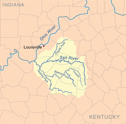
The Salt River is a 150-mile-long (240 km) river in the U.S. state of Kentucky that drains 2,920 square miles (7,600 km2). It begins near Parksville, Kentucky, rising from the north slope of Persimmon Knob south of KY 300 between Alum Springs and Wilsonville, and ends at the Ohio River near West Point. Taylorsville Lake is formed from the Salt River, and Guist Creek Lake is also in its drainage basin.
Beargrass Creek is the name given to several forks of a creek in Jefferson County, Kentucky. The Beargrass Creek watershed is one of the largest in the county, draining over 60 square miles (160 km2). It is fairly small, with an average discharge of 103 cubic feet per second at River Road in Louisville.
The Long Run massacre occurred on 13 September 1781 at the intersection of Floyd's Fork creek with Long Run Creek, along the Falls Trace, a trail in what is now eastern Jefferson County, Kentucky.

Shelby Township is one of ten townships in Jefferson County, Indiana, United States. As of the 2020 census, its population was 1,151 and it contained 458 housing units.

James John Floyd was an early settler of St. Matthews, Kentucky, and helped lay out Louisville. In Kentucky, he served as a Colonel of the Kentucky Militia in which he participated in raids with George Rogers Clark and later became one of the first judges of Kentucky.

Hammersley Fork is a tributary of Kettle Creek in Potter County and Clinton County, Pennsylvania, in the United States. It is approximately 10.0 miles (16.1 km) long and flows through Warton Township in Potter County and Leidy Township in Clinton County. The watershed of the stream has an area of 32.7 square miles (85 km2). The main rock formation in the watershed is the Pottsville Formation. A number of bridges cross the stream.