Dolphin Island is an island situated in the Dampier Archipelago in the Pilbara region of Western Australia. Visitors are able to camp within 100 metres (328 ft) of the high water mark on all of the beaches on the island except for the south eastern side.
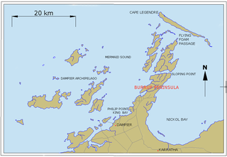
The Dampier Archipelago is a group of 42 islands near the town of Dampier in the Pilbara, Western Australia.
Dampier is a major industrial port in the Pilbara region in the northwest of Western Australia. It is located near the city of Karratha and Port Walcott.
The passage is named after the 33-ton coastal schooner Flying Foam,[2] which disappeared without trace in March 1872.[3] Its name is, however, most prominently associated with the 1868 massacre of indigenous Australians in the area.
The Flying Foam Massacre was a series of confrontations between white settlers and Aboriginal people around Flying Foam Passage on Murujuga, Western Australia. The confrontations occurred between February and May 1868, and were triggered by the killing of two police officers and a local workman. The confrontations resulted in the deaths of unknown number of Jaburara people with estimates ranging between 15 and 150 dead.
Indigenous Australians are the Aboriginal and Torres Strait Islander peoples of Australia, descended from groups that existed in Australia and surrounding islands before British colonisation. The time of arrival of the first Indigenous peoples on the continent and nearby islands is a matter of debate among researchers. The earliest conclusively human remains found in Australia are those of Mungo Man LM3 and Mungo Lady, which have been dated to around 50,000 years BP. Recent archaeological evidence from the analysis of charcoal and artefacts revealing human use suggests a date as early as 65,000 BP. Luminescence dating has suggested habitation in Arnhem Land as far back as 60,000 years BP. Evidence of fires in South-West Australia suggest 'human presence in Australia 120,000 years ago', although more research is required. Genetic research has inferred a date of habitation as early as 80,000 years BP. Other estimates have ranged up to 100,000 years and 125,000 years BP.
The passage is a significant site of vessels lost.[4]
↑ Dickson, Rod (1994) Ships registered in Western Australia from 1856: their details, their owners and their fate Fremantle, W.A: Western Australian Maritime Museum Report (Western Australian Maritime Museum. Dept. of Maritime Archaeology) ; no. 80. v. 1 1856-1884
↑ Murray, Ian, with Marion Hercock (2008) Where on the coast is that? Carlisle, W.A.: Hesperian Press. ISBN978-0-85905-452-2. page 107
A geographic coordinate system is a coordinate system that enables every location on Earth to be specified by a set of numbers, letters or symbols. The coordinates are often chosen such that one of the numbers represents a vertical position and two or three of the numbers represent a horizontal position; alternatively, a geographic position may be expressed in a combined three-dimensional Cartesian vector. A common choice of coordinates is latitude, longitude and elevation. To specify a location on a plane requires a map projection.
Related Research Articles
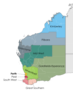
The Peel region is one of the nine regions of Western Australia. It is located on the west coast of Western Australia, about 75 km (47 mi) south of the state capital, Perth. It consists of the City of Mandurah, and the Shires of Boddington, Murray, Serpentine-Jarrahdale and Waroona.
Koolyanobbing is located 54 km NNE of the town of Southern Cross, Western Australia. Iron ore is mined here by a subsidiary of Cliffs Natural Resources of Cleveland, Ohio. Ore is railed to port at Esperance for export. The current operations commenced in 1993. The current owner and operator of the lease is Mineral Resources Limited; MRL took over from Cliffs Natural Resources in July 2018.
Crawley is a suburb of Perth, Western Australia, located within the City of Subiaco and City of Perth. The earlier name of the locality was Crawley Park. It was named by an early landowner Henry Charles Sutherland, whose mother's maiden name was Crawley.
The Western Australian Museum is the state museum for Western Australia. It has six main sites: in Perth within the Perth Cultural Centre, two in Fremantle, and one each in Albany, Geraldton, and Kalgoorlie-Boulder. The Western Australian Museum is a statutory authority within the Culture and the Arts Portfolio, established under the Museum Act 1969.
The Heineken Classic was a men's professional golf tournament played in Australia from 1990 to 2005 as part of the PGA Tour of Australasia. From 1990 to 1992 it was called the Vines Classic.
York Road was the main road connecting Guildford and York, in Western Australia, during the 19th and 20th centuries.
Wanneroo is a suburb of Perth, Western Australia, located within the City of Wanneroo.
Murujuga, usually known as the Burrup Peninsula, is an island in the Dampier Archipelago, in the Pilbara region of Western Australia, containing the town of Dampier. Originally named Dampier Island after the English navigator William Dampier, it lies 3 km off the Pilbara coast. In 1963 the island became an artificial peninsula when it was connected to the mainland by a causeway for a road and railway. In 1979 Dampier Peninsula was renamed Burrup Peninsula after Mt Burrup, the highest peak on the island, which had been named after Henry Burrup, a Union Bank clerk murdered in 1885 at Roebourne.
Pilbara newspapers is a selection of newspapers published in the Pilbara region of Western Australia.
Isseka is a small town in the Mid West region of Western Australia.
The Esperance Branch Railway is a railway from Kalgoorlie to the port of Esperance in Western Australia.
John Bramston Russell Oldham (1907–1999) at Subiaco, Western Australia) was a landscape architect in Western Australia. Oldham, a pioneer of landscape architecture in Australia, and his journalist wife Ray were founding members of the National Trust (WA) and were prominent in the fight to save some of WA’s heritage buildings during the 1960s and 1970s.
Nanutarra is a locality in Western Australia adjacent to where the Ashburton river is crossed by the North West Coastal Highway. It is also close to the turn-off for State Route 136 to Paraburdoo and Tom Price. It is 40 kilometres (25 mi) south of the Onslow turn-off in the Cane River conservation park where it is on either side of the highway.
Our Rural Magazine was a monthly magazine produced between 1926 and 1946 by the WA Correspondence School of the Education Department of Western Australia for school children who were located in isolated circumstances. In the inter-war period, many isolated rural localities did not have primary schools, and the students were required to have their education by correspondence.
The Kimberley Echo is a Kununurra, Western Australia based community newspaper.
InterSector is a Western Australian government publication that followed the earlier Public Service notices . The formal title is InterSector : official newsletter of the Western Australian Public Sector.
The Esplanade Reserve in Perth, Western Australia was a heritage listed public space between Perth Water and the Perth central business district. It formed part of and was, on occasions, also incorrectly referred to as the Perth foreshore, or the Perth waterfront. The public space was resumed by the Western Australian state government in April 2012 as part of the Elizabeth Quay redevelopment of the Perth waterfront area.
Sherwood Court is a short sloping road between St Georges Terrace in Perth, Western Australia and The Esplanade (Perth) with Allendale Square on the upper corner, and Lawson Apartments on the lower.
Duncan Graham is an Australian trained journalist and blogger.
This page is based on this Wikipedia article Text is available under the CC BY-SA 4.0 license; additional terms may apply. Images, videos and audio are available under their respective licenses.