
The Berwyn range is an isolated and sparsely populated area of moorland in the northeast of Wales, roughly bounded by Llangollen in the northeast, Corwen in the northwest, Bala in the southwest, and Oswestry in the southeast.

The Rhinogydd are a range of mountains located east of Harlech in North Wales. The name Rhinogydd derives from the names of two of the more famous peaks, Rhinog Fawr and Rhinog Fach, although the greatest elevation in the range is reached by Y Llethr, 756 m.

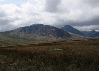
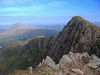
Pen Llithrig y Wrach is a mountain peak in Snowdonia, North Wales. It is one of the four Marilyns that make up the Carneddau range. To the east is Creigiau Gleision, another Marilyn, while to the west are Pen yr Helgi Du and Carnedd Llewelyn. Craig Eigiau and Llyn Eigiau can be seen to the north, while Gallt yr Ogof, Glyder Fach and Tryfan can be viewed to the south.

Fan Brycheiniog is the highest peak at a height of 802.5 metres (2,633 ft) in the Black Mountain region of the Brecon Beacons National Park in southern Wales. There is a trig point at the peak and on the edge of the escarpment, and nearby, a stone shelter with an inner seat. It lies just inside the historic county of Brecknockshire which gives the mountain its Welsh name. A subsidiary top, less than a kilometre from the summit along the ridge to the northwest, is the highest point of the neighbouring county of Carmarthenshire. Fan Brycheiniog is also within the Fforest Fawr Geopark designated in 2005 in recognition of the area's geological heritage. The views of the moorland and open country to the north are spectacular when the weather is clear, and reveals the isolation of the range, especially when compared with the more popular Pen y Fan range to the east.
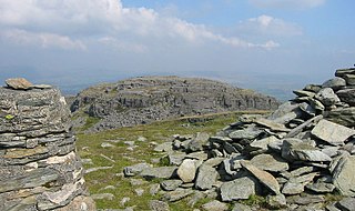
Foel Penolau is a mountain close to Moel Ysgyfarnogod in Snowdonia, North Wales and is the northernmost summit of the Rhinogydd, and overlooks Llyn Trawsfynydd. From the summit it is possible to see the towns of Porthmadog and Blaenau Ffestiniog. As a result of a revised survey of its topographical prominence, Foel Penolau gained Hewitt and Simms status in December 2018 when its prominence was measured to be above 30 m (98 ft).

Corn Du is a summit of the twin topped Pen y Fan and the second highest peak in South Wales at 871.5 m (2,864 ft), situated in the Brecon Beacons National Park. The summit itself is marked by a well structured Bronze Age cairn with a central burial cist like that on nearby Pen y Fan. The two summits are visible from great distances owing to their height above the surrounding moorland, and are famous landmarks. The views from the peaks are also panoramic and very extensive, the Black Mountain and Fforest Fawr being especially obvious to the west. Mynydd Epynt is visible to the north behind the county town of Brecon, and other parts of the escarpment to the east.

Erw y Ddafad-ddu is a subsidiary summit of Aran Fawddwy in southern Snowdonia, North Wales, Wales, United Kingdom. It is the third highest peak in the Aran mountain range.

Aran Benllyn is a subsidiary summit of Aran Fawddwy in southern Snowdonia, North Wales, Wales, United Kingdom. It is the second highest peak in the Aran mountain range.
Y Foel Goch is a mountain in Snowdonia, north-west Wales, and is a sister peak along with Gallt yr Ogof to Glyder Fach. Between Glyder Fach and its summit lies Llyn Caseg-fraith, a popular lake for photographing Tryfan and its reflection.
Gallt yr Ogof is a mountain in Snowdonia, North Wales. It is a subsidiary top of Glyder Fawr, and is the most easterly point in the Glyderau mountain range, not including the hill Cefn y Capel. Gallt yr Ogof is 763 metres high.

Arenig Fach is a mountain in southern Snowdonia, north Wales. It is a peak in the Arenig range and lies to the north of its parent peak Arenig Fawr.

Moel Llyfnant is a mountain in the southern portion of the Snowdonia National Park in Gwynedd, Wales. It is a peak in the Arenig mountain range. It lies to the west of Arenig Fawr. It has one notable top, the twin peaked Gallt y Daren, being at the end of its west ridge.
Gallt y Daren is a peak in the southern half of the Snowdonia National Park in Gwynedd, North Wales, and forms part of the Arenig mountain range. It is a top of Moel Llyfnant, and is twin peaked. It lies to the west of Moel Llyfnant.

Trum y Gwragedd is a top of Foel y Geifr in the Hirnantau. These hills rise from the south east shores of Bala Lake.

Cyrniau Nod is a mountain summit in north east Wales. It is a former Marilyn, the Marilyn summit now being the nearby Foel Cedig. Its summit has the Snowdonia National Park boundary running through it. A number of rivers and streams rise from near the mountain including Afon Tanat, Afon Cedig and Nant Ystrad-y-Groes.

Esgeiriau Gwynion is a mountain in north Wales. It is the smallest of the three Marilyns that form the Aran range, the others being Aran Fawddwy and Glasgwm.

Waun Garnedd-y-filiast is a top of Carnedd y Filiast on the border of the Snowdonia National park near Cerrigydrudion in North Wales. It is part of the Arenig mountain range. It is also a peak in an area of moorland known as the Migneint.
Y Lliwedd East Peak is the twin top of Y Lliwedd in the Snowdonia National Park, North Wales. It is only 5 metres shorter than the main summit of Y Lliwedd.

Moel y Cerrig Duon is a subsidiary summit of Esgeiriau Gwynion in Gwynedd in north Wales.

