Related Research Articles
Sapulu is a village at the east side of Savai'i island in Samoa. The village is part of the electoral constituency Fa'asaleleaga 1 which is within the larger political district (Itumalo) of Fa'asaleleaga.
Tino i Iva, is a village at the east end of Savai'i island in Samoa. The village is part of the electoral constituency Fa'asaleleaga 2 which is within the larger political district (Itumalo) of Fa'asaleleaga.
Vaiafai is a village at the east end of Savai'i island in Samoa. The village is part of the electoral constituency Fa'asaleleaga 2 which is within the larger political district (Itumalo) of Fa'asaleleaga.
Salelavalu Tai is a village at the east end of Savai'i island in Samoa. The village is part of the electoral constituency Fa'asaleleaga 2 which is within the larger political district (Itumalo) of Fa'asaleleaga.
Salelavalu Uta is a village at the east end of Savai'i island in Samoa. The village is part of the electoral constituency Fa'asaleleaga 2 which is within the larger political district (Itumalo) of Fa'asaleleaga.
Vaimaga is a village on the east coast of Savai'i island in Samoa. The village is part of the electoral constituency Fa'asaleleaga 3 which is within the larger political district (Itumalo) of Fa'asaleleaga.
Sa'asa'ai is a village on the east coast of Savai'i island in Samoa. The village is part of the electoral constituency of Fa'asaleleaga 4 which is within the larger political district (Itumalo) of Fa'asaleleaga. The population is 526.
Saipipi is a village on the east coast of Savai'i island in Samoa. The village is part of the electoral constituency Fa'asaleleaga 4 which is within the larger political district (Itumalo) of Fa'asaleleaga.
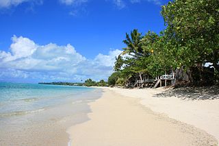
Lano is a village on the north east coast of Savai'i island in Samoa. The village is part of the electoral constituency Fa'asaleleaga 5 which is within the larger political district (Itumalo) of Fa'asaleleaga. The population is 695.
Pu'apu'a is a village on the north east coast of Savai'i island in Samoa. The village is part of the electoral constituency Fa'asaleleaga 5 which is within the larger political district (Itumalo) of Fa'asaleleaga. The population is 510.

Fatausi is a village on the island of Savai'i in Samoa. It is situated on the east coast of the island in the district of Fa'asaleleaga and the electoral district of Fa'asaleleaga 3. The population is 205.
Malae is a village on the island of Savai'i in Samoa. It is situated on the east coast of the island in the district of Fa'asaleleaga and the electoral district of Fa'asaleleaga 4. The population is 216.
Salimu is a village on the island of Savai'i in Samoa. It is situated on the east coast of the island in the district of Fa'asaleleaga and the electoral district of Fa'asaleleaga 4. The population is 260.
Siufaga is a village on the island of Savai'i in Samoa. It is situated on the east coast of the island in the district of Fa'asaleleaga and the electoral district of Fa'asaleleaga 4. The population is 695.
Eveeve is a village on the island of Savai'i in Samoa. It is situated on the east coast of the island in the district of Fa'asaleleaga and the electoral district of Fa'asaleleaga 3. The population is 132.
Tapuelele is a village on the island of Savai'i in Samoa. It is situated on the east coast of the island in the district of Fa'asaleleaga and the electoral district of Fa'asaleleaga 3. The population is 302.
Vaisaulu is a village on the island of Savai'i in Samoa. It is situated on the east coast of the island in the district of Fa'asaleleaga and the electoral district of Fa'asaleleaga 2. The population is 147.
Foua is a village on the island of Savai'i in Samoa. It is situated on the east coast of the island in the district of Fa'asaleleaga and the electoral district of Fa'asaleleaga 1. The population is 317.
Saletagaloa is a village on the island of Savai'i in Samoa. It is situated on the east coast of the island in the district of Fa'asaleleaga and the electoral district of Fa'asaleleaga 1. The population is 260.
Satalafai is a village on the island of Savai'i in Samoa. It is situated on the east coast of the island in the district of Fa'asaleleaga and the electoral district of Fa'asaleleaga 1. The population is 430.
References
- ↑ "Electoral Constituencies Act 2019" (PDF). Parliament of Samoa. 31 January 2019. Archived from the original (PDF) on 4 October 2021. Retrieved 11 September 2021.
- ↑ "Census 2016 Preliminary count" (PDF). Samoa Bureau of Statistics. Retrieved 11 September 2021.
13°40′S172°11′W / 13.667°S 172.183°W
Traditional center: Safotulafai Township: Salelologa | ||
| Villages |  | |
| Airport & Ferry Terminal |
| |
| Education & Schools | ||
| Conservation & Environment | ||
| Electoral constituencies: Faipule Districts |
| |
| | This article about a geographical location in Samoa is a stub. You can help Wikipedia by expanding it. |