Salelologa

Last updated
Salelologa
Township & Ferry Terminal
Samoa ferry Fotu o Samoa II.jpg
Fotu o Samoa II ferry at Salelologa wharf.
American Samoa location map.svg
Red pog.svg
Salelologa
Pacific Ocean laea relief location map.jpg
Red pog.svg
Salelologa
Coordinates: 13°44′16″S172°13′14″W / 13.73778°S 172.22056°W / -13.73778; -172.22056 Coordinates: 13°44′16″S172°13′14″W / 13.73778°S 172.22056°W / -13.73778; -172.22056
Country Flag of Samoa.svg  Samoa
District Fa'asaleleaga
Time zone +13
Salelologa

Salelologa is a village district at the east end of Savai'i island in Samoa. It is the main entry point into the island with the only ferry terminal on Savai'i. It also serves as the main township for shopping and public amenities with a market selling fresh produce and arts and crafts.

Contents

Salelologa is made up of smaller sub-villages pito nu'u and falls within the electoral district of Fa'asaleleaga. [1]

Township

The township consists of one main shopping street. Fresh fish, locally grown produce and arts and crafts are sold at the Salelologa Market (makeki) which was recently moved to a new site by the wharf in 2009. The market is open six days a week, Monday to Saturday. Most shops and markets in Samoa close on Sundays with a few small outlets opening in the late afternoon. There are also several small supermarkets, a wholesaler, petrol stations, bakeries such as Retzlaff's bakery, budget hotels and accommodation, [2] as well as public amenities such as internet access, banks and Western Union money transfer outlets.

Transport

The main island highway which reaches most parts of Savai'i is tar-sealed and well maintained. Salelologa is the only township on Savai'i and is the main destination for arrivals and departures for local public transport and visitors to the island.

Ferry terminal

The wharf and ferry terminal as seen from an approaching ferry. Salelologa wharf and ferry terminal, Savai'i, Samoa - August 2016.jpg
The wharf and ferry terminal as seen from an approaching ferry.

Salelologa wharf is the main port of entry into the island and is the only ferry terminal on Savai'i. The inter-island passenger and vehicle ferries operate in the Apolima Strait between Salelologa and Mulifanua wharf at the north west corner of Upolu. The ferries are managed by the government and operate seven days a week during the day. Ferry arrivals and departures are usually every two hours. A one-way trip takes about 90 minutes with views of Apolima and Manono islands to the south during the crossing.

Maota Airport

Maota Airport is an airstrip 10 minutes south of Salelologa. Most flights operate between Faleolo International Airport on Upolu; however, the service can be sporadic.

Local transport

There are buses, taxis and rental car companies at the ferry terminal and in the township. The bus route is via the main highway which generally follows the coastline of the island where most villages and settlements are situated. The buses are usually scheduled around the ferry arrivals and departures with short stops at the market and shops before heading out of town. There are no 'bus stop' signs on Savai'i and catching a bus involves standing by the side of the road or signalling with a wave at the driver. Local buses are the cheapest form of transport on the island, although they can fill very quickly at the ferry terminal. There are plenty of taxis at the wharf and around the township during the day. Rental cars are available on Savai'i, although prior bookings are essential.

Public library

Savai'i Public Library, the only public library on the island, is situated in Salelologa by the old market. It is sometimes referred to as Salelologa Library. [3] It is the only branch of Samoa's central Nelson Memorial Public Library in the capital Apia on Upolu island.

Climate

Climate data for Salelologa
MonthJanFebMarAprMayJunJulAugSepOctNovDecYear
Average high °C (°F)30.1
(86.2)
28.9
(84.0)
29.9
(85.8)
30.4
(86.7)
29.0
(84.2)
29.1
(84.4)
28.8
(83.8)
29.1
(84.4)
29.0
(84.2)
28.7
(83.7)
30.2
(86.4)
30.1
(86.2)
29.4
(85.0)
Average low °C (°F)24.3
(75.7)
23.9
(75.0)
23.1
(73.6)
24.3
(75.7)
23.0
(73.4)
23.4
(74.1)
22.9
(73.2)
24.4
(75.9)
23.0
(73.4)
24.1
(75.4)
23.5
(74.3)
23.1
(73.6)
23.6
(74.4)
Average precipitation mm (inches)410
(16.13)
330
(13.01)
392
(15.45)
232
(9.12)
174
(6.86)
193
(7.59)
140
(5.53)
150
(5.92)
186
(7.32)
264
(10.41)
280
(11.04)
379
(14.91)
3,130
(123.29)
Average precipitation days (≥ 0.1in)22.918.618.414.112.67.99.79.911.114.916.118.0174.2
Source: [4]

Related Research Articles

<span class="mw-page-title-main">Transport in Samoa</span> Overview of transport in Samoa

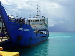
Transport in Samoa includes one international airport situated on the north west coast of Upolu island, paved highways reaching most parts of the two main islands, one main port in the capital Apia and two ports servicing mainly inter island ferries for vehicles and passengers between the two main islands, Upolu and Savai'i.

<span class="mw-page-title-main">Samoan Islands</span> Archipelago in the South Pacific Ocean

The Samoan Islands are an archipelago covering 3,030 km2 (1,170 sq mi) in the central South Pacific, forming part of Polynesia and of the wider region of Oceania. Administratively, the archipelago comprises all of the Independent State of Samoa and most of American Samoa. The land masses of the two Samoan jurisdictions are separated by 64 km (40 mi) of ocean at their closest points.

<span class="mw-page-title-main">Savaiʻi</span> Island in the Samoan Islands chain

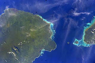
Savaiʻi is the largest and highest island both in Samoa and in the Samoan Islands chain. The island is also the sixth largest in Polynesia, behind the three main islands of New Zealand and the Hawaiian Islands of Hawaii and Maui.

Mulifanua Village District in Aiga-i-le-Tai, Samoa

Mulifanua is a village on the north-western tip of the island of Upolu, in Samoa. In the modern era, it is the capital of Aiga-i-le-Tai district. Mulifanua wharf is the main ferry terminal for inter-island vehicle and passenger travel across the Apolima Strait between Upolu and the island of Savai'i.

<span class="mw-page-title-main">Apolima</span> Island in Samoa

Apolima is the smallest of the four inhabited islands of Samoa. It lies in the Apolima Strait, between the country's two largest islands: Upolu to the east, and Savai'i to the west.

Manono Island

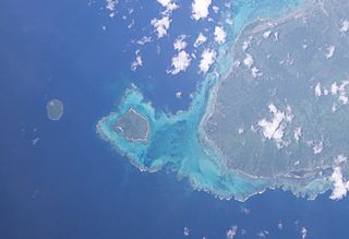
Manono is an island of Samoa, situated in the Apolima Strait between the main islands of Savai'i and Upolu, 3.4 km west-northwest off Lefatu Cape, the westernmost point of Upolu.

Aiga-i-le-Tai District in Samoa

Aiga-i-le-Tai is a district of Samoa which includes the small islands of Manono, Apolima and tiny uninhabited Nu'ulopa lying in the Apolima Strait between the country's two main islands of Upolu and Savai'i.

Faʻasaleleaga District in Samoa

Faʻasaleleaga is a district of Samoa situated on the eastern side of Savaiʻi island. It has a population of 13,566.

Apolima Strait

The Apolima Strait is about 13 km wide and separates the two largest islands of Samoa: Savai'i to the northwest, and Upolu to the southeast.

Apai is one of four small villages on Manono Island in Samoa. The village population is 124.

Faleu is one of four small historic villages on Manono Island in Samoa. The village population is 250.

Salua is one of four small villages on Manono Island in Samoa. The village population is 136.

Satapuala is a village situated on the north west coast Upolu island in Samoa. The village is part of A'ana Alofi 4 Electoral Constituency which forms part of the larger political district A'ana. It has a population of 1963.

Maota Airport is the main domestic airport on the island of Savai'i in Samoa. It is situated near Salelologa at the east end of Savai'i. The airport is located 10 minutes south of Salelologa township and ferry terminal. The airport has been in operation since the early 1990s. It was tar-sealed in 1994, and declared a customs port of entry in 1997. In the past, the airport has served flights from Faleolo International Airport on the main island Upolu and Asau Airport at the northwest end of Savai'i, but domestic flights were discontinued before 2000. The airport was refurbished in late 2020, and Samoa Airways resumed domestic flights in September that year.

Patamea is a village on the island of Savai'i in Samoa. While most villages on Savai'i are situated near the sea, Patamea is situated inland, away from the coast. The village is in the Gaga'emauga political district near the central north coast of the island. The population is 649.

Tuasivi is a village on the north east coast of Savai'i island in Samoa. The village is in the electoral district of Fa'asaleleaga and has a population of 193.

Apolima Tai

Apolima Tai is a small village settlement on the tiny volcanic island of Apolima in Samoa. The village is situated on the north side of the islet which is in the political district of Aiga-i-le-Tai.

Lepuia'i is one of four small villages on Manono Island in Samoa. The village population is 183.

Savai'i Public Library is the only public library on the island of Savai'i, the largest and westernmost island in Samoa.

References

  1. "Samoa Territorial Constituencies Act 1963". Pacific Islands Legal Information Institute. Archived from the original on 5 June 2011. Retrieved 19 December 2009.
  2. "WEBSITE.WS - Your Internet Address For Life™".
  3. "History of Libraries in Samoa". Library Association of Samoa. Retrieved 27 May 2010.
  4. ""Climate Salelologa"". World Weather and Climate Information. Retrieved August 29, 2018.