Samoa, officially the Independent State of Samoa and known until 1997 as Western Samoa, is an island country in Polynesia, consisting of two main islands ; two smaller, inhabited islands ; and several smaller, uninhabited islands, including the Aleipata Islands. Samoa is located 64 km west of American Samoa, 889 km northeast of Tonga, 1,152 km northeast of Fiji, 483 km east of Wallis and Futuna, 1,151 km southeast of Tuvalu, 519 km south of Tokelau, 4,190 km southwest of Hawaii, and 610 km northwest of Niue. The capital and largest city is Apia. The Lapita people discovered and settled the Samoan Islands around 3,500 years ago. They developed a Samoan language and Samoan cultural identity.

The Samoan Islands are an archipelago covering 3,030 km2 (1,170 sq mi) in the central South Pacific, forming part of Polynesia and of the wider region of Oceania. Administratively, the archipelago comprises all of the Independent State of Samoa and most of American Samoa. The land masses of the two Samoan jurisdictions are separated by 64 km of ocean at their closest points.

Savaiʻi is the largest and highest island both in Samoa and in the Samoan Islands chain. The island is also the sixth largest in Polynesia, behind the three main islands of New Zealand and the Hawaiian Islands of Hawaii and Maui. While it is larger than the second main island, Upolu, it is significantly less populated.

Mulifanua is a village on the north-western tip of the island of Upolu, in Samoa. In the modern era, it is the capital of Aiga-i-le-Tai district. Mulifanua wharf is the main ferry terminal for inter-island vehicle and passenger travel across the Apolima Strait between Upolu and the island of Savai'i.

Salelologa is a village district at the east end of Savai'i island in Samoa. It is the main entry point into the island with the only ferry terminal on Savai'i. It also serves as the main township for shopping and public amenities with a market selling fresh produce and arts and crafts.
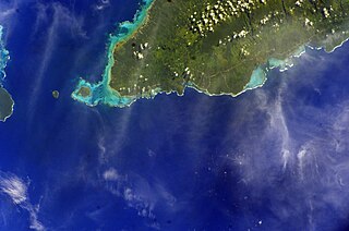
Manono is an island of Samoa, situated in the Apolima Strait between the main islands of Savai'i and Upolu, 3.4 km west-northwest off Lefatu Cape, the westernmost point of Upolu. By population, as well as by area, it is Samoa’s third largest island.
Samoa is divided into eleven itūmālō, which were established well before the arrival of Europeans. Each district has its own constitutional foundation (faavae), rooted in the traditional order of title precedence as outlined in its faalupega.
Aʻana is a district of Samoa. It is on the western third of Upolu island, with a small exclave surrounded by Aiga-i-le-Tai. It has an area of 193 km2 and a population of 23,265. The main centre is Leulumoega.
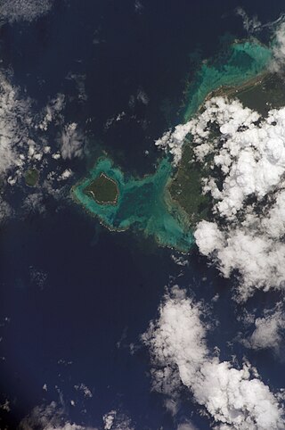
Aiga-i-le-Tai is a district of Samoa which includes the small islands of Manono, Apolima and tiny uninhabited Nu'ulopa lying in the Apolima Strait between the country's two main islands of Upolu and Savai'i.

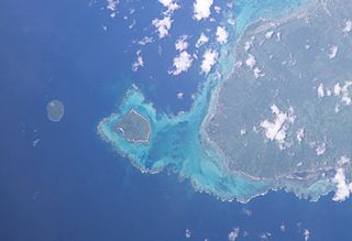
The Apolima Strait is about 13 km wide and separates the two largest islands of Samoa: Savai'i to the northwest, and Upolu to the southeast.
Salamumu is a village on the south west coast of Upolu island in Samoa. The village has two settlements, Salamumu Uta and Salamumu Tai.
Apai is one of four small villages on Manono Island in Samoa, in central South Pacific Ocean. The village population is 124.
Faleu is one of four small historic villages on Manono Island in Samoa in central South Pacific Ocean. The village population is 250.
Salua is one of four small villages on Manono Island in Samoa, in central South Pacific Ocean. The village population is 136.
Satapuala is a village situated on the north west coast Upolu island in Samoa. The village is part of A'ana Alofi 4 Electoral Constituency which forms part of the larger political district A'ana. It has a population of 1963.
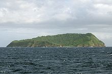
Nuʻulopa is a small, uninhabited island in the Apolima Strait between the islands of Upolu and Savaiʻi in Samoa, in central South Pacific Ocean. The island is part of the Aiga-i-le-Tai district.

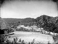
Archaeology of Samoa began with the first systematic survey of archaeological remains on Savai'i island by Jack Golson in 1957. Since then, surveys and studies in the rest of Samoa have uncovered major findings of settlements, stone and earth mounds including star mounds, Lapita pottery remains and pre-historic artifacts.

Apolima Tai is a village on the small volcanic island of Apolima in Samoa, on the north side in the political district of Aiga-i-le-Tai. Its population is 96. Apolima island is one of three in the Apolima Strait between Samoan's two main islands, Upolu and Savai'i. The others are Manono, which has four villages, and uninhabited Nu'ulopa.
Lepuia'i is one of four small villages on Manono Island in Samoa in central South Pacific Ocean. The village population is 183.