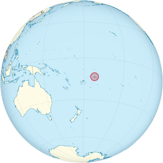
Samoa, officially the Independent State of Samoa and until 1997 known as Western Samoa, is a Polynesian island country consisting of two main islands ; two smaller, inhabited islands ; and several smaller, uninhabited islands, including the Aleipata Islands. Samoa is located 64 km (40 mi) west of American Samoa, 889 km (552 mi) northeast of Tonga, 1,152 km (716 mi) northeast of Fiji, 483 km (300 mi) east of Wallis and Futuna, 1,151 km (715 mi) southeast of Tuvalu, 519 km (322 mi) south of Tokelau, 4,190 km (2,600 mi) southwest of Hawaii, and 610 km (380 mi) northwest of Niue. The capital and largest city is Apia. The Lapita people discovered and settled the Samoan Islands around 3,500 years ago. They developed a Samoan language and Samoan cultural identity.

Upolu is an island in Samoa, formed by a massive basaltic shield volcano which rises from the seafloor of the western Pacific Ocean. The island is 75 kilometres long and 1,125 square kilometres in area, making it the second largest of the Samoan Islands by area. With approximately 145,000 inhabitants, it is by far the most populous of the Samoan Islands. Upolu is situated to the southeast of Savai'i, the "big island". Apia, the capital, is in the middle of the north coast, and Faleolo International Airport at the western end of the island. The island has not had any historically recorded eruptions, although there is evidence of three lava flows, dating back only to between a few hundred and a few thousand years ago.

The Samoan Islands are an archipelago covering 3,030 km2 (1,170 sq mi) in the central South Pacific, forming part of Polynesia and of the wider region of Oceania. Administratively, the archipelago comprises all of the Independent State of Samoa and most of American Samoa. The land masses of the two Samoan jurisdictions are separated by 64 km (40 mi) of ocean at their closest points.

Savaiʻi is the largest and highest island both in Samoa and in the Samoan Islands chain. The island is also the sixth largest in Polynesia, behind the three main islands of New Zealand and the Hawaiian Islands of Hawaii and Maui. While it is larger than the second main island, Upolu, it is significantly less populated.

Salelologa is a village district at the east end of Savai'i island in Samoa. It is the main entry point into the island with the only ferry terminal on Savai'i. It also serves as the main township for shopping and public amenities with a market selling fresh produce and arts and crafts.

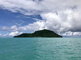
Apolima is the smallest of the four inhabited islands of Samoa, in central South Pacific Ocean. It lies in the Apolima Strait, between the country's two largest islands: Upolu to the east, and Savai'i to the west.
Manono is an island of Samoa, situated in the Apolima Strait between the main islands of Savai'i and Upolu, 3.4 km west-northwest off Lefatu Cape, the westernmost point of Upolu. By population just like by area it’s Samoa’s third largest island.
Aʻana is a district of Samoa. It is on the western third of Upolu island, with a small exclave surrounded by Aiga-i-le-Tai. It has an area of 193 km² and a population of 23,265. The main centre is Leulumoega.
Aiga-i-le-Tai is a district of Samoa which includes the small islands of Manono, Apolima and tiny uninhabited Nu'ulopa lying in the Apolima Strait between the country's two main islands of Upolu and Savai'i.

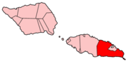
Ātua is an ancient political district of Samoa, consisting of most of the eastern section of Upolu and the island Tutuila. Within Samoa’s traditional polity, Ātua is ruled by the Tui Ātua together with the group of six senior orators of Lufilufi and 13 senior matai from throughout Ātua, comprising the Fale Ātua. The fono (meeting) of Atua's rulers takes place in Lufilufi on the great malae of Lalogafu'afu'a.

Gagaʻemauga is a district on the island of Savaiʻi in Samoa. The district is situated on the central north side of Savaiʻi. The name 'Gagaʻemauga' literally means "near side of the mountain", meaning the eastern side of the mountain chain running through the centre of Savaiʻi Island.

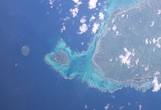
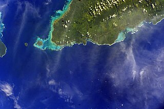
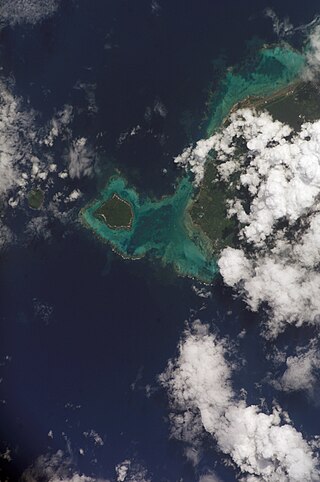
Nuʻutele is an island that consists of a volcanic tuff ring. It lies 1.3 km off the eastern end of Upolu island, Samoa, in central South Pacific Ocean. It is the largest of the four Aleipata Islands, with an area of 1.15 km2 (0.44 sq mi).

The Apolima Strait is about 13 km wide and separates the two largest islands of Samoa: Savai'i to the northwest, and Upolu to the southeast.

The Aleipata Islands are a group of four uninhabited islands off the eastern end of Upolu Island, Samoa, in central South Pacific Ocean. The islands are eroded volcanic tuff rings, and consist of a small northern pair on Upolu's barrier reef, and a larger southern pair outside it. Collectively the islands have an area of about 1.7 km2 (0.66 sq mi). Administratively, the islands are part of the Atua district. The islands are important for Samoa's biodiversity and are protected by the Aleipata Marine Protected Area.
Maota Airport is the main domestic airport on the island of Savai'i in Samoa. It is situated near Salelologa at the east end of Savai'i. The airport is located 10 minutes south of Salelologa township and ferry terminal. The airport has been in operation since the early 1990s. It was tar-sealed in 1994, and declared a customs port of entry in 1997. In the past, the airport has served flights from Faleolo International Airport on the main island Upolu and Asau Airport at the northwest end of Savai'i, but domestic flights were discontinued before 2000. The airport was refurbished in late 2020, and Samoa Airways resumed domestic flights in September that year.
Nuʻulopa is a small, uninhabited island in the Apolima Strait between the islands of Upolu and Savaiʻi in Samoa, in central South Pacific Ocean. The island is part of the Aiga-i-le-Tai district.

Archaeology of Samoa began with the first systematic survey of archaeological remains on Savai'i island by Jack Golson in 1957. Since then, surveys and studies in the rest of Samoa have uncovered major findings of settlements, stone and earth mounds including star mounds, Lapita pottery remains and pre-historic artifacts.
Nuʻusafeʻe Island is a small, uninhabited island in Samoa. The island is located off the southeast coast of Upolu Island, near the Upolu village of Poutasi.
Naval Base Upolu was a naval base built by the United States Navy in 1942 to support the World War II effort. The base was located on Upolu Island, Samoa in the Western Pacific Ocean, part of the Samoan Islands's Naval Base Samoa. After the surprise attack on Naval Station Pearl Harbor on December 7, 1941, the US Navy was in need of setting up more advance bases in the Pacific Ocean. At Naval Base Upolu the Navy built a sea port, an airbase and a seaplane base.